Featured: Lost Secrets - an adventure during Neolithic times

Lost Secrets - an adventure during Neolithic times

Random Image


Bygate Hill

Sign the Petition to Protect Broxy Kennels Hillfort - Click Here

Sign the Petition to Protect Broxy Kennels Hillfort - Click Here

Who's Online

There are currently, 319 guests and 4 members online.

You are a guest. To join in, please register for free by clicking here

Sponsors

<< Our Photo Pages >> Grimspound - Ancient Village or Settlement in England in Devon

Submitted by h_fenton on Tuesday, 31 January 2023  Page Views: 27866

Multi-periodSite Name: Grimspound
Country: England County: Devon Type: Ancient Village or Settlement
 Nearest Village: Postbridge
Map Ref: SX70078090  Landranger Map Number: 191
Latitude: 50.613300N  Longitude: 3.837802W
Condition:
5Perfect
4Almost Perfect
3Reasonable but with some damage
2Ruined but still recognisable as an ancient site
1Pretty much destroyed, possibly visible as crop marks
0No data.
-1Completely destroyed
4 Ambience:
5Superb
4Good
3Ordinary
2Not Good
1Awful
0No data.
4 Access:
5Can be driven to, probably with disabled access
4Short walk on a footpath
3Requiring a bit more of a walk
2A long walk
1In the middle of nowhere, a nightmare to find
0No data.
4 Accuracy:
5co-ordinates taken by GPS or official recorded co-ordinates
4co-ordinates scaled from a detailed map
3co-ordinates scaled from a bad map
2co-ordinates of the nearest village
1co-ordinates of the nearest town
0no data
5

Internal Links:
External Links:

I have visited· I would like to visit

SumDoood whese001 would like to visit

TheCaptain visited on 6th Dec 2022 - their rating: Cond: 4 Amb: 4 Access: 3 I've not been to Grimspound for many a year now, in fact too long. It really is wonderful, with a multiplicity of circular hut buildings within a huge encircling wall. A lovely place to sit and eat my lunch in one of the huts, with the Challacombe stone rows visible on the hillside the other side of the valley and the Warren House Inn way beyond them. Triffic.

lauraaurora visited on 3rd May 2021 - their rating: Cond: 3 Amb: 5 Access: 3

lucasn visited on 24th Jun 2019 - their rating: Cond: 4 Amb: 4 Access: 4

SandyG visited on 3rd Mar 2016 - their rating: Cond: 4 Amb: 5 Access: 4

lichen visited on 31st Aug 2015 - their rating: Cond: 4 Amb: 5 Access: 4

jeffrep visited on 20th May 2011 - their rating: Cond: 4 Amb: 4 Access: 4

graemefield visited on 27th Aug 1999 - their rating: Cond: 3 Amb: 5 Access: 3

graemefield visited on 26th Nov 1998 - their rating: Cond: 4 Amb: 5 Access: 2

Ergler TimPrevett h_fenton TheWhiteRider AngieLake hamish NickyD heidavey have visited here

Average ratings for this site from all visit loggers: Condition: 3.75 Ambience: 4.63 Access: 3.38
Grimspound
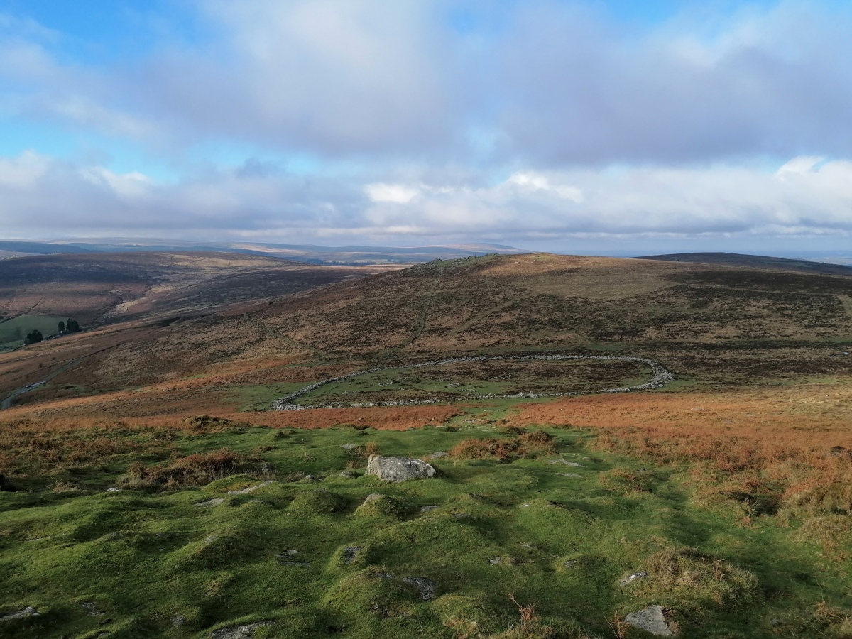
Grimspound submitted by TheCaptain : Looking down on Grimspound from near the top of Hameldown Tor, looking north towards Hookney Tor. For some reason, most of the Grimspound views seen are looking south from Hookney Tor. (Vote or comment on this photo)
The best known and most easily accessible ancient settlement on Dartmoor. Grimspound is a late Bronze Age settlement, in an excellent state of preservation. The name was first recorded by the Reverend Richard Polwhele in 1797 - it was probably derived from the Anglo Saxon god of war, Grim (more commonly known as Woden, or Odin).

Grimspound is located on a saddle between Hameldown and Hookney Tor, at 450 metres above sea level. 24 stone hut circles have been officially recorded here, although there are probably remains of more within the enclosure which has an area of over 16,000 square metres (four acres). Many of these hut circles feature L-shaped entrance passages.

The site is enclosed by a stone wall, interrupted by a large, paved entrance facing south, uphill towards Hameldown. The wall would have been substantial - in some places its ruins are more than 15 feet (3 m) in thickness. However, the site is of limited value from a defensive point of view, so the assumption is that this was used to keep livestock in, and predators out.

This article is licensed under the GNU Free Documentation License. It uses material from the Wikipedia article "Grimspound".

Update October 2019: This enclosed settlement is featured on the Prehistoric Dartmoor Walks (PDW) website - see their entries for the Grimspound Enclosed Settlement and the Grimspound Enclosed Settlement (more information).

The settlement is also recorded as Pastscape Monument No. 445637 and as MDV8778 (Grimspound enclosed settlement, Manaton) on the Devon & Dartmoor HER.

The site is also scheduled as Historic England List ID 1014667 (Grimspound, a partially enclosed prehistoric settlement with field system and two post-medieval caches between Hookney Tor and Hameldown Tor).
You may be viewing yesterday's version of this page. To see the most up to date information please register for a free account.

Grimspound
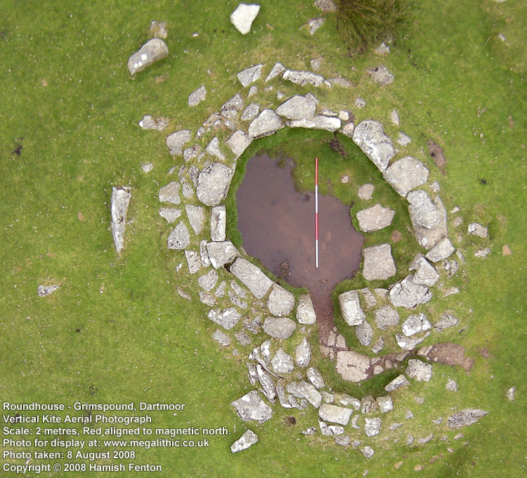
Grimspound submitted by h_fenton : Grimspound, Dartmoor. Low Level Vertical Kite Aerial photograph of a roundhouse. The scale is aligned red to magnetic north. The scale is 2 metres long Photo taken: 8 August 2008 (3 comments - Vote or comment on this photo)

Grimspound
Grimspound submitted by graemefield : Grimspound August 1999 (Vote or comment on this photo)

Grimspound
Grimspound submitted by postman : Dez rez (Vote or comment on this photo)

Grimspound
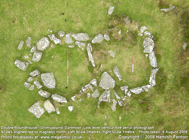
Grimspound submitted by h_fenton : Grimspound, Double roundhouse, Low level vertical kite aerial photograph. the left scale is 2 metres long, the right 1 metre, both scales are aligned red to magnetic north. Photo taken: 8 August 2008 (Vote or comment on this photo)

Grimspound
Grimspound submitted by wayland : Grimspound on Dartmoor SX 701 809 (2 comments - Vote or comment on this photo)

Grimspound
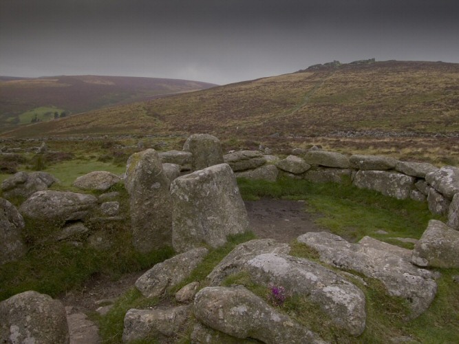
Grimspound submitted by jeffrep : A Grimspound Ancient Settlement Roundhouse (with Jamb Stones Upright at Entrance), Dartmoor National Park, Devon, England.

Grimspound
Grimspound submitted by h_fenton : Grimspound. Original entrance on the south eastern side. Low level vertical kite aerial photograph. The scale is 1 metre long. Photo taken: 8 August 2008 (1 comment)

Grimspound
Grimspound submitted by cazzyjane : A round house at Grimspound. Looking across to the Warren House Inn in the distance. (3 comments)

Grimspound
Grimspound submitted by h_fenton : Grimspound, from the northwest (Hookney Tor). Low level oblique kite aerial photograph. There are a few people on the right side of the photo to help show scale. Photo taken: 8 August 2008

Grimspound
Grimspound submitted by SandyG : Gordon Fisher and Janet Daynes (ACE Archaeology Club) in roundhouse 3. (3 comments)

Grimspound
Grimspound submitted by postman : From on high Hookney Tor

Grimspound
Grimspound submitted by postman : Grimspound's west end

Grimspound
Grimspound submitted by Bladup : A Hut Circle in Grimspound.

Grimspound
Grimspound submitted by Bladup : Though the entrance of Grimspound and over the site towards Hookney Tor.

Grimspound
Grimspound submitted by TimPrevett : 14/05/09

Grimspound
Grimspound submitted by TheWhiteRider : Inside the best preserved hut circle looking towards the doorway.

Grimspound
Grimspound submitted by Dal_gCais : hut circle (1 comment)

Grimspound
Grimspound submitted by Dal_gCais : southern (uphill) entrance (1 comment)

Grimspound
Grimspound submitted by TheCaptain : Grimspound as seen from the Challacombe Down triple stone row. (3 comments)

Grimspound
Grimspound submitted by graemefield : Picture taken shortly after the 1894 restoration. Caption reads: "Partially restored. Camera pointing SW. Apr 28th, 1894." ©Burnard (The Dartmoor Trust) ©DartmoorArchive.Org https://dartmoorarchive.org/record/3478

Grimspound
Grimspound submitted by Bladup : A Hut at Grimspound.

Grimspound
Grimspound submitted by Bladup : The big Ancient walls at Grimspound lit up by sunrays, Seen from Hookney Tor.

Grimspound
Grimspound submitted by postman : Mid afternoon late August.

Grimspound
Grimspound submitted by postman : A room with a view

These are just the first 25 photos of Grimspound. If you log in with a free user account you will be able to see our entire collection.

Do not use the above information on other web sites or publications without permission of the contributor.
Click here to see more info for this site

Nearby sites

Click here to view sites on an interactive OS map

Key: Red: member's photo, Blue: 3rd party photo, Yellow: other image, Green: no photo - please go there and take one, Grey: site destroyed

Download sites to:
KML (Google Earth)
GPX (GPS waypoints)
CSV (Garmin/Navman)
CSV (Excel)

To unlock full downloads you need to sign up as a Contributory Member. Otherwise downloads are limited to 50 sites.

Richard's Ancient Sites and Curiosity Pages by Richard Pederick


Turn off the page maps and other distractions

Nearby sites listing. In the following links * = Image available
 408m SE 143° Hamel Down Platform Cairn (North)* Cairn (SX70318057)
 437m NE 51° Grimslake Cist* Cairn (SX7041881165)
 443m NNW 336° Hookney Tor Cairn* Cairn (SX6990281310)
 863m SSE 155° Hamel Down Cross* Ancient Cross (SX70428011)
 1.1km W 259° Challacombe Down Standing Stone* Standing Stone (Menhir) (SX69028072)
 1.1km W 264° Challacombe rows* Multiple Stone Rows / Avenue (SX68988082)
 1.1km W 265° Challacombe Down Cairn Circle* Cairn (SX68968083)
 1.1km SSE 152° Broad Barrow (Hamel Down)* Round Barrow(s) (SX70577990)
 1.3km NNW 329° Shapley Common Ancient Village or Settlement (SX69428206)
 1.4km ESE 115° Berry Pound Ancient Village or Settlement (SX713803)
 1.5km SSE 159° Single Barrow (Hamel Down)* Round Barrow(s) (SX70577953)
 1.5km SSE 158° Hamel Down* Barrow Cemetery (SX706795)
 1.6km WNW 297° Birch Tor Cairn* Cairn (SX6868681654)
 1.6km ESE 118° Hamel Down row* Stone Row / Alignment (SX71488010)
 1.8km SSE 160° Two Barrows (Hamel Down)* Round Barrow(s) (SX70657921)
 1.9km SSE 160° Blackaton Down north (Hamel Down)* Cairn (SX70687909)
 2.0km SSE 159° Blackaton Down south (Hamel Down)* Cairn (SX70737904)
 2.0km NW 308° Bush Down Settlement* Ancient Village or Settlement (SX6849282173)
 2.1km SSE 158° Hamel Down Beacon cairn* Cairn (SX70837891)
 2.2km WNW 288° Bennet's Cross* Ancient Cross (SX68008162)
 2.2km N 351° Challacombe Cross Settlement* Ancient Village or Settlement (SX69788313)
 2.4km N 2° Leeper Cross* Ancient Cross (SX7022083325)
 2.6km WSW 248° Soussons Down Stone Row Multiple Stone Rows / Avenue (SX6767079980)
 2.7km WSW 241° Soussons Down Cairns* Barrow Cemetery (SX6770079671)
 2.7km SSE 158° Hamel Down Cairn and Cist* Cairn (SX7100878345)
View more nearby sites and additional images

<< Foxborough Standing Stone (5)

El Pozuelo Roundhouses >>

Please add your thoughts on this site

Prehistoric Settlements

Prehistoric Settlements

Archived Web links for Grimspound

Richard's Ancient Sites and Curiosity Pages by Richard Pederick

Sponsors

Auto-Translation (Google)

Translate from English into:

"Grimspound" | Login/Create an Account | 9 News and Comments
  
Go back to top of page    Comments are owned by the poster. We aren't responsible for their content.
Re: Grimspound surprise by Anonymous on Saturday, 04 February 2023
One of the most interesting sites I have visited last September while touring in Dartmoor.
The place in between the two hills looks like a powerful well preserved ancient settlement and I can say I could feel magic among those old rocks. I took many pictures and felt like being there while an ancient ceremony was taking place, it was like travelling back in time. Awesome experience.
The parking along the road is very small, there where 4 cars and one of theme was robbed by some thieves who broke a window while the owners were visiting... they had left a bag and other things visible in the car...very sad for them. I would suggest to be very careful while leaving cars in isolated parking like that one...
[ Reply to This ]

Re: Grimspound surprise by indianajowan on Wednesday, 07 July 2021
(User Info | Send a Message)
Interestingly I did my dissertation on this site.
Several particular points came up when I was evaluating its defensibility, such as much of the thought around it being indefensible comes solely from the results of the excavations of 1893 and 1894 (over a hundred years ago, and also preceding several years of constant change in archaeological theory and methodology, as well as interpretation) and modern viewpoints about its positioning.

In addition, there were several discrepancies between Shillabeer's map of 1829 and the DEC map of 1893/4, including several missing features and structures that could tell a different story!
[ Reply to This ]

Grimspound, Dartmoor by lucasn on Thursday, 08 August 2019
(User Info | Send a Message)
[ Reply to This ]

Re: Grimspound by Anonymous on Wednesday, 22 November 2017
Interesting site, but why was it there? Agriculturally there is not much around, yet the clue is over the valley, the old tin mining scars. This was the Bronze age, tin is needed to make bronze, so I think Grimspound was a tin mining settlement, possible walled to protect the valuable metal.
[ Reply to This ]
    Re: Grimspound by TheCaptain on Wednesday, 22 November 2017
    (User Info | Send a Message)
    The climate and local ground conditions have changed substantially since Grimspound was created, so agricultural conditions will be completely different now to what they were then.
    [ Reply to This ]
    Re: Grimspound by Anonymous on Wednesday, 19 June 2019
    I agree, it is the only sensible reason why a walled village would exist there. Tin was very important, and rare, at that time. It would have had great value.

    It sits on what is called ''''miners path'''' which links other tin mines nearby, so it is a focal point for tin mining.
    [ Reply to This ]

Grimspound by ernar on Wednesday, 12 October 2005
(User Info | Send a Message)
Grimspound is a late Bronze Age settlement, in an excellent state of preservation, situated on Dartmoor, Devon, in the United Kingdom. The name was first recorded by the Reverend Richard Polwhele in 1797 - it was probably derived from the Anglo Saxon god of war, Grim (more commonly known as Woden, or Odin).

Grimspound is located on a saddle between Hameldown and Hookney Tor, at 450 metres above sea level. 24 stone hut circles have been officially recorded here, although there are probably remains of more within the enclosure which has an area of over 16,000 square metres (four acres). Many of these hut circles feature L-shaped entrance passages.

The site is enclosed by a stone wall, interrupted by a large, paved entrance facing south, uphill towards Hameldown. The wall would have been substantial - in some places its ruins are more than 15 feet (3 m) in thickness. However, the site is of limited value from a defensive point of view, so the assumption is that this was used to keep livestock in, and predators out.

This article is licensed under the GNU Free Documentation License. It uses material from the Wikipedia article "Grimspound".
[ Reply to This ]

Re: Grimspound by pippagill on Saturday, 27 August 2005
(User Info | Send a Message)
Having just visited Grimspound today, and being very impressed with the very identifiable layout of this bronze age village, I found myself looking for more information on the web. I would direct people to the attached website where I read quite a bit about how it would have looked some 3,000 years ago - interesting reading.

myweb.tiscali.co.uk/andyspatch/grimspound.htm
[ Reply to This ]

Re: Grimspound surprise by benson on Wednesday, 17 August 2005
(User Info | Send a Message)
I literally stumbled across this structure yesterday whilst taking a walk up the nearby tor. I first viewed it from the top of the hill and was quite taken aback, not least because I hadn't expected to see it! Added to the surprise was that there wasn't another soul about, despite it being a beautiful sunny day during the school holidays. As I descended towards the huge stone structure, which I estimated at 100m in diameter, I began to formulate ideas as to its purpose. I assumed the causeway linking the tor and the enclosure was a relatively recent addition to protect the hillside but I couldn't help wonder if there was an ancient link. I was thinking some sort of worship place at this point. The walls of the structure were extremely impressive, being constructed of quite massive stones most requiring many men to lift them yet there were hundreds producing the enclosure. Within, I was again surprised to find that the numerous piles of stones actually made up smaller enclosures, perhaps 3m wide. Most seemed far too small to be actual dwellings, yet one in particular had a most definate serpentine entrance to it. To the south lay a definate entrance to the entire site which, like the previously mentioned 'dwelling' seem rather too perfect - a modern addition/reconstruction, I assumed. In order to get a good picture of the entire site, I walked a little further up the opposite hill, only to find other almost hidden structures in the turf. These made definate and very straight lines, apparently unconnected with the main site. My final impression was a site, probably bronze age almost certainly a dwelling or fortification of some nature but with possible religious undertones.
Overall, I found my 'discovery' a breath of fresh air in the age of overcommersialised and over-informed sites. It was fabulous being able to formulate my own conclusions from what I could see in the brief time I had (the flying ants were terrible) Of couse, since checking up my find on the net, I found a wealth of information on it, but had I had this prior to yesterday, my experience would have been less intense.
I would recommend anyone to visit this site, but maybe try it without reading up about it first. Difficult if you're on this website, I expect!!
[ Reply to This ]

Your Name: Anonymous [ Register Now ]
Subject:


Add your comment or contribution to this page. Spam or offensive posts are deleted immediately, don't even bother

<<< What is five plus one as a number? (Please type the answer to this question in the little box on the left)
You can also embed videos and other things. For Youtube please copy and paste the 'embed code'.
For Google Street View please include Street View in the text.
Create a web link like this: <a href="https://www.megalithic.co.uk">This is a link</a>  

Allowed HTML is:
<p> <b> <i> <a> <img> <em> <br> <strong> <blockquote> <tt> <li> <ol> <ul> <object> <param> <embed> <iframe>

We would like to know more about this location. Please feel free to add a brief description and any relevant information in your own language.
Wir möchten mehr über diese Stätte erfahren. Bitte zögern Sie nicht, eine kurze Beschreibung und relevante Informationen in Deutsch hinzuzufügen.
Nous aimerions en savoir encore un peu sur les lieux. S'il vous plaît n'hesitez pas à ajouter une courte description et tous les renseignements pertinents dans votre propre langue.
Quisieramos informarnos un poco más de las lugares. No dude en añadir una breve descripción y otros datos relevantes en su propio idioma.