


<< Our Photo Pages >> Burridge Ancient Settlement - Ancient Village or Settlement in England in Devon
Submitted by RingPaw on Saturday, 07 January 2006 Page Views: 10906
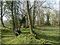
Multi-periodSite Name: Burridge Ancient SettlementCountry: England County: Devon Type: Ancient Village or Settlement
Nearest Town: South Molton Nearest Village: Cheldon, Chawleigh
Map Ref: SS742126
Latitude: 50.899134N Longitude: 3.790301W
Condition:
| 5 | Perfect |
| 4 | Almost Perfect |
| 3 | Reasonable but with some damage |
| 2 | Ruined but still recognisable as an ancient site |
| 1 | Pretty much destroyed, possibly visible as crop marks |
| 0 | No data. |
| -1 | Completely destroyed |
| 5 | Superb |
| 4 | Good |
| 3 | Ordinary |
| 2 | Not Good |
| 1 | Awful |
| 0 | No data. |
| 5 | Can be driven to, probably with disabled access |
| 4 | Short walk on a footpath |
| 3 | Requiring a bit more of a walk |
| 2 | A long walk |
| 1 | In the middle of nowhere, a nightmare to find |
| 0 | No data. |
| 5 | co-ordinates taken by GPS or official recorded co-ordinates |
| 4 | co-ordinates scaled from a detailed map |
| 3 | co-ordinates scaled from a bad map |
| 2 | co-ordinates of the nearest village |
| 1 | co-ordinates of the nearest town |
| 0 | no data |
Internal Links:
External Links:
")
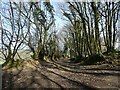
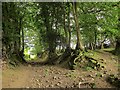
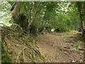
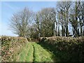
It is easily accessed by a footpath from the unclassified road between the B 3042 and the hamlet of Cheldon. It is signposted from this road (a walk up a trackway of 150 metres or so). This track continues on the other side of the road and appears to have been an important local artery in past times (marked as a lane on the Old Map). All in all a quietly impressive site well secluded from modern life.
You may be viewing yesterday's version of this page. To see the most up to date information please register for a free account.
")
")
")
Do not use the above information on other web sites or publications without permission of the contributor.
Nearby Images from Geograph Britain and Ireland:
©2021(licence)
©2014(licence)
©2015(licence)
©2021(licence)
©2021(licence)
The above images may not be of the site on this page, they are loaded from Geograph.
Please Submit an Image of this site or go out and take one for us!
Click here to see more info for this site
Nearby sites
Key: Red: member's photo, Blue: 3rd party photo, Yellow: other image, Green: no photo - please go there and take one, Grey: site destroyed
Download sites to:
KML (Google Earth)
GPX (GPS waypoints)
CSV (Garmin/Navman)
CSV (Excel)
To unlock full downloads you need to sign up as a Contributory Member. Otherwise downloads are limited to 50 sites.
Turn off the page maps and other distractions
Nearby sites listing. In the following links * = Image available
4.6km NE 44° Long Stone (East Worlington)* Standing Stone (Menhir) (SS77511587)
5.3km NNE 21° Meshaw Moor (West)* Round Barrow(s) (SS762175)
6.8km ESE 117° Berry Castle (Black Dog)* Hillfort (SS802093)
8.0km NNW 348° St. Rumon's well* Holy Well or Sacred Spring (SS727205)
8.7km SSW 202° Bow Timber Circle Timber Circle (SS707046)
10.3km ENE 63° Berry Castle (Devon)* Hillfort (SS835171)
10.4km SSE 163° Copplestone Cross* Ancient Cross (SS7706802606)
11.4km ENE 75° Witheridge Moor Barrows* Barrow Cemetery (SS853152)
11.5km SSW 196° Bow Henge* Henge (SS70750160)
12.0km S 184° Puddock's Well* Holy Well or Sacred Spring (SS731006)
12.2km ENE 61° Holy Trinity Well (Rackenford)* Holy Well or Sacred Spring (SS85001825)
12.3km NE 41° Beaples Hill* Standing Stone (Menhir) (SS8248621693)
12.6km SSW 205° North Tawton B Cursus Cursus (SS685013)
13.1km NE 44° Knowstone Inner Moor Round Barrow(s) (SS8346021869)
13.5km NNW 347° South Molton Museum* Museum (SS7142125848)
13.8km N 5° Garliford Hillfort (SS757263)
14.3km SW 219° North Tawton A Cursus Cursus (SS649017)
15.3km S 172° Lethen Castle Hillfort (SX761974)
15.3km SE 142° St Boniface's Well (Crediton)* Holy Well or Sacred Spring (SS834003)
15.4km SE 142° Libbett's Well* Holy Well or Sacred Spring (SS835003)
16.3km SSE 148° Uton Holy Well* Holy Well or Sacred Spring (SX825986)
16.5km NW 307° Brightley Barton Camp Hillfort (SS6124822911)
16.5km NW 320° St. Urith's well* Holy Well or Sacred Spring (SS638255)
16.6km SE 132° Shobrooke Holy Well* Holy Well or Sacred Spring (SS8632301236)
16.7km SE 132° Shobrooke Church Preaching Cross Ancient Cross (SS863011)
View more nearby sites and additional images


 We would like to know more about this location. Please feel free to add a brief description and any relevant information in your own language.
 Wir möchten mehr über diese Stätte erfahren. Bitte zögern Sie nicht, eine kurze Beschreibung und relevante Informationen in Deutsch hinzuzufügen.
 Nous aimerions en savoir encore un peu sur les lieux. S'il vous plaît n'hesitez pas à ajouter une courte description et tous les renseignements pertinents dans votre propre langue.
 Quisieramos informarnos un poco más de las lugares. No dude en añadir una breve descripción y otros datos relevantes en su propio idioma.