 with our Megalithic Portal iPhone app")


<< Our Photo Pages >> The Cross of Brancuf - Early Christian Sculptured Stone in Wales in South Glamorgan
Submitted by Sunny100 on Sunday, 10 October 2010 Page Views: 5727
Early Medieval (Dark Age)Site Name: The Cross of Brancuf Alternative Name: The Baglan Cross, Brancu's CrossCountry: Wales
NOTE: This site is 2.34 km away from the location you searched for.
County: South Glamorgan Type: Early Christian Sculptured Stone
Nearest Town: Baglan
Map Ref: SS753922
Latitude: 51.614774N Longitude: 3.802439W
Condition:
| 5 | Perfect |
| 4 | Almost Perfect |
| 3 | Reasonable but with some damage |
| 2 | Ruined but still recognisable as an ancient site |
| 1 | Pretty much destroyed, possibly visible as crop marks |
| 0 | No data. |
| -1 | Completely destroyed |
| 5 | Superb |
| 4 | Good |
| 3 | Ordinary |
| 2 | Not Good |
| 1 | Awful |
| 0 | No data. |
| 5 | Can be driven to, probably with disabled access |
| 4 | Short walk on a footpath |
| 3 | Requiring a bit more of a walk |
| 2 | A long walk |
| 1 | In the middle of nowhere, a nightmare to find |
| 0 | No data. |
| 5 | co-ordinates taken by GPS or official recorded co-ordinates |
| 4 | co-ordinates scaled from a detailed map |
| 3 | co-ordinates scaled from a bad map |
| 2 | co-ordinates of the nearest village |
| 1 | co-ordinates of the nearest town |
| 0 | no data |
Internal Links:
External Links:
")
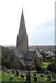
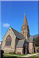
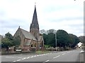
The Cross of Brancuf stands in the church of St Catherine at Baglan. It is an intricately sculptured cross-slab with a Latin cross and an inscription recalling Brancuf.
Originally it stood in the old St Baglan's church but that fell into ruin in the late 19th century and the slab was removed to St Catherine's. St Baglan (Bagelan), son of King Ithael Hoel of Brittany, was a 6th century hermit and follower of St Illytud. He founded the first church at the town that now takes his name.
In the vestry of St Catherine's church a cross-slab dating from the 8th-10th century CE. It is intricately decorated with a Celtic-style cross formed out of knotwork (cord-plait knotwork) and interlacing; the ends of each arm are probably of a Latin design. Also there is a Latin inscription: FECIT BRANCUF or perhaps BRANCU which when translated reads 'was made by Brancuf'. However, the person known as Brancuf is unknown.
You may be viewing yesterday's version of this page. To see the most up to date information please register for a free account.
Do not use the above information on other web sites or publications without permission of the contributor.
Nearby Images from Geograph Britain and Ireland:
©2014(licence)
©2020(licence)
©2005(licence)
©2014(licence)
©2018(licence)
The above images may not be of the site on this page, they are loaded from Geograph.
Please Submit an Image of this site or go out and take one for us!
Click here to see more info for this site
Nearby sites
Key: Red: member's photo, Blue: 3rd party photo, Yellow: other image, Green: no photo - please go there and take one, Grey: site destroyed
Download sites to:
KML (Google Earth)
GPX (GPS waypoints)
CSV (Garmin/Navman)
CSV (Excel)
To unlock full downloads you need to sign up as a Contributory Member. Otherwise downloads are limited to 50 sites.
Turn off the page maps and other distractions
Nearby sites listing. In the following links * = Image available
751m NNW 335° Baglan Gorsedd Circle* Modern Stone Circle etc (SS7500492891)
988m SE 134° Mynydd Dinas* Hillfort (SS760915)
1.8km NE 39° Buarth y Gaer* Misc. Earthwork (SS765936)
3.6km E 96° Pen-Y-Castell (Cwmavon) Ancient Village or Settlement (SS78859175)
5.3km SE 134° Mynydd Brombil Ancient Village or Settlement (SS79048839)
5.4km N 360° Neath Museum and Art Gallery Museum (SS754976)
5.4km SE 129° Ergyd Isaf 1 Round Barrow(s) (SS79438864)
5.4km SE 129° Ergyd Isaf 2 Round Barrow(s) (SS79458866)
5.9km ESE 119° Ergyd Uchaf Cairn Cairn (SS80438922)
6.3km ESE 121° Ergyd Uchaf Cairn 2 Cairn (SS80618887)
7.1km SE 142° Ffynnon Pedr* Holy Well or Sacred Spring (SS79538654)
7.2km SE 138° Half Moon Camp Ancient Village or Settlement (SS79968673)
7.2km SE 142° Margam Gorsedd Stone Circle* Modern Stone Circle etc (SS7961886387)
7.3km SE 135° Ffynnon Gyffyr* Holy Well or Sacred Spring (SS8030486920)
7.5km SE 135° Lady's Well (South Glamorgan)* Holy Well or Sacred Spring (SS80478675)
7.5km NNW 334° Mynydd Drumau Cairn I Cairn (SS72189903)
7.5km SE 139° Margam Stones Museum* Museum (SS801864)
7.5km NNW 334° Mynydd Drumau Cairn II Cairn (SS72159904)
7.6km SE 135° Mynydd y Castell* Hillfort (SS806867)
7.8km NNW 337° Carreg Bica Stone* Standing Stone (Menhir) (SS7248899461)
7.8km NNW 338° Careg Bica Cairn Cairn (SS72519948)
8.6km ESE 112° Twmpath Diwlith Round Barrow(s) (SS83218879)
8.9km SE 124° Ton-Mawr Hill Fort* Hillfort (SS825870)
9.0km ESE 116° Rhyd Blaen-Y-Cwm Enclosure* Misc. Earthwork (SS833880)
9.8km SSE 148° Tyn'r y selar* Standing Stone (Menhir) (SS80248374)
View more nearby sites and additional images


 We would like to know more about this location. Please feel free to add a brief description and any relevant information in your own language.
 Wir möchten mehr über diese Stätte erfahren. Bitte zögern Sie nicht, eine kurze Beschreibung und relevante Informationen in Deutsch hinzuzufügen.
 Nous aimerions en savoir encore un peu sur les lieux. S'il vous plaît n'hesitez pas à ajouter une courte description et tous les renseignements pertinents dans votre propre langue.
 Quisieramos informarnos un poco más de las lugares. No dude en añadir una breve descripción y otros datos relevantes en su propio idioma.