


<< Text Pages >> Careg Bica Cairn - Cairn in Wales in Mid Glamorgan
Submitted by coldrum on Friday, 30 January 2009 Page Views: 3502
Neolithic and Bronze AgeSite Name: Careg Bica CairnCountry: Wales
NOTE: This site is 1.871 km away from the location you searched for.
County: Mid Glamorgan Type: Cairn
Nearest Town: Neath
Map Ref: SS72519948
Latitude: 51.679570N Longitude: 3.845368W
Condition:
| 5 | Perfect |
| 4 | Almost Perfect |
| 3 | Reasonable but with some damage |
| 2 | Ruined but still recognisable as an ancient site |
| 1 | Pretty much destroyed, possibly visible as crop marks |
| 0 | No data. |
| -1 | Completely destroyed |
| 5 | Superb |
| 4 | Good |
| 3 | Ordinary |
| 2 | Not Good |
| 1 | Awful |
| 0 | No data. |
| 5 | Can be driven to, probably with disabled access |
| 4 | Short walk on a footpath |
| 3 | Requiring a bit more of a walk |
| 2 | A long walk |
| 1 | In the middle of nowhere, a nightmare to find |
| 0 | No data. |
| 5 | co-ordinates taken by GPS or official recorded co-ordinates |
| 4 | co-ordinates scaled from a detailed map |
| 3 | co-ordinates scaled from a bad map |
| 2 | co-ordinates of the nearest village |
| 1 | co-ordinates of the nearest town |
| 0 | no data |
Be the first person to rate this site - see the 'Contribute!' box in the right hand menu.
Internal Links:
External Links:
Cairn in Mid Glamorgan
A pear-shaped stony mound, 21m by 14.3m and 0.6m high.
RCAHMW Coflein record:
Careg Bica.
You may be viewing yesterday's version of this page. To see the most up to date information please register for a free account.
")
")
")
")
Do not use the above information on other web sites or publications without permission of the contributor.
Nearby Images from Geograph Britain and Ireland:
©2007(licence)
©2007(licence)
©2014(licence)
©2021(licence)
©2013(licence)
The above images may not be of the site on this page, they are loaded from Geograph.
Please Submit an Image of this site or go out and take one for us!
Click here to see more info for this site
Nearby sites
Key: Red: member's photo, Blue: 3rd party photo, Yellow: other image, Green: no photo - please go there and take one, Grey: site destroyed
Download sites to:
KML (Google Earth)
GPX (GPS waypoints)
CSV (Garmin/Navman)
CSV (Excel)
To unlock full downloads you need to sign up as a Contributory Member. Otherwise downloads are limited to 50 sites.
Turn off the page maps and other distractions
Nearby sites listing. In the following links * = Image available
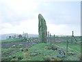
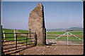
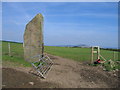
29m SW 228° Carreg Bica Stone* Standing Stone (Menhir) (SS7248899461)
557m SW 215° Mynydd Drumau Cairn I Cairn (SS72189903)
568m SW 218° Mynydd Drumau Cairn II Cairn (SS72159904)
3.4km ESE 122° Neath Museum and Art Gallery Museum (SS754976)
4.0km NNE 22° Rhos Standing Stones* Standing Stones (SN741031)
6.1km N 357° Llangiwg* Holy Well or Sacred Spring (SN72380559)
6.7km WSW 256° Ffynnon Deml* Holy Well or Sacred Spring (SS65969798)
6.9km NNW 334° Carn Llechart Megalithic Complex* Modern Stone Circle etc (SN69670576)
7.0km SSE 158° Baglan Gorsedd Circle* Modern Stone Circle etc (SS7500492891)
7.1km SE 144° Buarth y Gaer* Misc. Earthwork (SS765936)
7.3km NNW 336° Carn Llechart Cairn Circle* Ring Cairn (SN69730627)
7.4km NNW 336° Carn Llechart Chambered Tomb* Chambered Tomb (SN69670627)
7.8km SSE 158° The Cross of Brancuf* Early Christian Sculptured Stone (SS753922)
8.7km SSE 155° Mynydd Dinas* Hillfort (SS760915)
9.2km NNW 347° Nant-Y-Gaseg modern stone circle* Modern Stone Circle etc (SN7063408515)
9.3km N 3° Cefn Gwrhyd Stone* Standing Stone (Menhir) (SN732088)
9.8km E 81° Carn Caca Cairn* Ring Cairn (SN82230077)
10.0km SE 139° Pen-Y-Castell (Cwmavon) Ancient Village or Settlement (SS78859175)
10.4km WNW 299° Penlle'r Bebyll* Ring Cairn (SN63510482)
10.5km WNW 299° Mynydd Pysgodlyn Cairn Cairn (SN63400475)
10.9km NNW 341° Llety'r-crydd cairn cemetery* Barrow Cemetery (SN69200991)
11.0km WSW 243° Cockett Standing Stone Standing Stone (Menhir) (SS6253194791)
11.1km NNW 340° Bancbryn platform cairn* Cairn (SN68950998)
11.1km N 358° Pen Y Waun NW 2 Cairn* Cairn (SN7234810576)
11.1km N 358° Pen Y Waun NW 1 Cairn* Cairn (SN7231810629)
View more nearby sites and additional images


 We would like to know more about this location. Please feel free to add a brief description and any relevant information in your own language.
 Wir möchten mehr über diese Stätte erfahren. Bitte zögern Sie nicht, eine kurze Beschreibung und relevante Informationen in Deutsch hinzuzufügen.
 Nous aimerions en savoir encore un peu sur les lieux. S'il vous plaît n'hesitez pas à ajouter une courte description et tous les renseignements pertinents dans votre propre langue.
 Quisieramos informarnos un poco más de las lugares. No dude en añadir una breve descripción y otros datos relevantes en su propio idioma.