


<< Text Pages >> Llanrhos church Inscribed Stone - Early Christian Sculptured Stone in Wales in Conwy
Submitted by coldrum on Wednesday, 27 January 2010 Page Views: 5064
Early Medieval (Dark Age)Site Name: Llanrhos church Inscribed StoneCountry: Wales County: Conwy Type: Early Christian Sculptured Stone
Map Ref: SH79338032
Latitude: 53.306034N Longitude: 3.812407W
Condition:
| 5 | Perfect |
| 4 | Almost Perfect |
| 3 | Reasonable but with some damage |
| 2 | Ruined but still recognisable as an ancient site |
| 1 | Pretty much destroyed, possibly visible as crop marks |
| 0 | No data. |
| -1 | Completely destroyed |
| 5 | Superb |
| 4 | Good |
| 3 | Ordinary |
| 2 | Not Good |
| 1 | Awful |
| 0 | No data. |
| 5 | Can be driven to, probably with disabled access |
| 4 | Short walk on a footpath |
| 3 | Requiring a bit more of a walk |
| 2 | A long walk |
| 1 | In the middle of nowhere, a nightmare to find |
| 0 | No data. |
| 5 | co-ordinates taken by GPS or official recorded co-ordinates |
| 4 | co-ordinates scaled from a detailed map |
| 3 | co-ordinates scaled from a bad map |
| 2 | co-ordinates of the nearest village |
| 1 | co-ordinates of the nearest town |
| 0 | no data |
Be the first person to rate this site - see the 'Contribute!' box in the right hand menu.
Internal Links:
External Links:
Early Christian Sculptured Stone in Conwy (Bwrdeistref Sirol)
"Inscribed stone found near Tyddyn Holland (at SH80788169), later moved to Llanrhos church (NPRN 43781).
The stone, thought to be a natural boulder, is 0.94m by 0.49m by 0.34m. It bears an inscription that has been read as:
SANCTINVS SACER[DOS]IN P[ACE]
Thought to commemorate 'Sanctinus the bishop' and dated to the 5th or early 6th century."
Source: Coflein.
You may be viewing yesterday's version of this page. To see the most up to date information please register for a free account.
Do not use the above information on other web sites or publications without permission of the contributor.
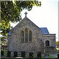
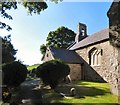
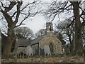
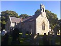
Nearby Images from Geograph Britain and Ireland:
©2016(licence)

©2006(licence)
©2016(licence)
©2020(licence)
©2016(licence)
The above images may not be of the site on this page, they are loaded from Geograph.
Please Submit an Image of this site or go out and take one for us!
Click here to see more info for this site
Nearby sites
Key: Red: member's photo, Blue: 3rd party photo, Yellow: other image, Green: no photo - please go there and take one, Grey: site destroyed
Download sites to:
KML (Google Earth)
GPX (GPS waypoints)
CSV (Garmin/Navman)
CSV (Excel)
To unlock full downloads you need to sign up as a Contributory Member. Otherwise downloads are limited to 50 sites.
Turn off the page maps and other distractions
Nearby sites listing. In the following links * = Image available
131m W 260° Ffynnon Santes Fair Holy Well or Sacred Spring (SH792803)
913m NE 47° Coed Gaer Hut Circle* Ancient Village or Settlement (SH80028092)
1.3km SSE 158° Bodysgallen* Hillfort (SH798791)
1.4km SW 230° Deganwy Castle* Ancient Village or Settlement (SH7822579455)
1.4km NNE 24° Ogof Tan-Y-Bryn Cave or Rock Shelter (SH79948160)
2.0km NE 47° Ogof Pant-Y-Wennol Cave Cave or Rock Shelter (SH80818161)
2.5km NW 326° Llandudno Museum* Museum (SH78008240)
2.8km NNW 330° Lower Kendrick's Cave Cave or Rock Shelter (SH780828)
2.8km NNW 330° Upper Kendrick's Cave* Cave or Rock Shelter (SH7798182821)
2.9km NNW 330° St Tudno's Cradle* Natural Stone / Erratic / Other Natural Feature (SH779829)
3.0km NNW 336° Llandudno Eisteddfod Circle* Modern Stone Circle etc (SH7816883048)
3.0km NNW 331° Pen-y-Dinas (Conwy)* Hillfort (SH779830)
3.2km NE 41° Ogof Rhiwleden Cave or Rock Shelter (SH81538269)
3.3km NNW 331° Great Orme Lost Chamber* Burial Chamber or Dolmen (SH778833)
3.4km NW 320° Lletty'r Filiast* Burial Chamber or Dolmen (SH7721382950)
3.4km NW 318° Great Orme barrow* Round Barrow(s) (SH771829)
3.6km NW 320° Great Orme Mine* Ancient Mine, Quarry or other Industry (SH7707683100)
3.9km NW 322° Brynia Poethion Ancient Village or Settlement (SH76998343)
3.9km E 96° Bryn Euryn* Hillfort (SH832798)
4.0km NW 313° Bishop's Quarries Hut Circle Ancient Village or Settlement (SH76498311)
4.1km NW 325° St Tudno's Well* Holy Well or Sacred Spring (SH77068378)
4.2km SW 231° Conway Mountain* Hillfort (SH760778)
4.4km NW 321° Ffynnon Rufeinig* Holy Well or Sacred Spring (SH766838)
4.7km NW 322° Hwylfa’r Ceirw Stone Alignment* Stone Row / Alignment (SH76568409)
4.8km NW 321° Hafnant Ancient Village or Settlement (SH76398409)
View more nearby sites and additional images


 We would like to know more about this location. Please feel free to add a brief description and any relevant information in your own language.
 Wir möchten mehr über diese Stätte erfahren. Bitte zögern Sie nicht, eine kurze Beschreibung und relevante Informationen in Deutsch hinzuzufügen.
 Nous aimerions en savoir encore un peu sur les lieux. S'il vous plaît n'hesitez pas à ajouter une courte description et tous les renseignements pertinents dans votre propre langue.
 Quisieramos informarnos un poco más de las lugares. No dude en añadir una breve descripción y otros datos relevantes en su propio idioma.