 with our Megalithic Portal iPhone app")


<< Text Pages >> Blackdown Rings - Hillfort in England in Devon
Submitted by vicky on Monday, 15 March 2004 Page Views: 14115
Iron Age and Later PrehistorySite Name: Blackdown Rings Alternative Name: Lodiswell RingsCountry: England County: Devon Type: Hillfort
Nearest Town: Kingsbridge Nearest Village: Stanton
Map Ref: SX720520 Landranger Map Number: 202
Latitude: 50.353958N Longitude: 3.800635W
Condition:
| 5 | Perfect |
| 4 | Almost Perfect |
| 3 | Reasonable but with some damage |
| 2 | Ruined but still recognisable as an ancient site |
| 1 | Pretty much destroyed, possibly visible as crop marks |
| 0 | No data. |
| -1 | Completely destroyed |
| 5 | Superb |
| 4 | Good |
| 3 | Ordinary |
| 2 | Not Good |
| 1 | Awful |
| 0 | No data. |
| 5 | Can be driven to, probably with disabled access |
| 4 | Short walk on a footpath |
| 3 | Requiring a bit more of a walk |
| 2 | A long walk |
| 1 | In the middle of nowhere, a nightmare to find |
| 0 | No data. |
| 5 | co-ordinates taken by GPS or official recorded co-ordinates |
| 4 | co-ordinates scaled from a detailed map |
| 3 | co-ordinates scaled from a bad map |
| 2 | co-ordinates of the nearest village |
| 1 | co-ordinates of the nearest town |
| 0 | no data |
Internal Links:
External Links:
Hillfort in Devon
Have you visited this site? Please add a comment below.
You may be viewing yesterday's version of this page. To see the most up to date information please register for a free account.
Do not use the above information on other web sites or publications without permission of the contributor.
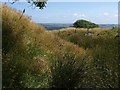
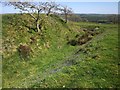
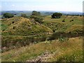
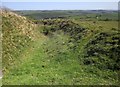
Nearby Images from Geograph Britain and Ireland:
©2009(licence)

©2012(licence)
©2014(licence)
©2009(licence)
©2014(licence)
The above images may not be of the site on this page, they are loaded from Geograph.
Please Submit an Image of this site or go out and take one for us!
Click here to see more info for this site
Nearby sites
Key: Red: member's photo, Blue: 3rd party photo, Yellow: other image, Green: no photo - please go there and take one, Grey: site destroyed
Download sites to:
KML (Google Earth)
GPX (GPS waypoints)
CSV (Garmin/Navman)
CSV (Excel)
To unlock full downloads you need to sign up as a Contributory Member. Otherwise downloads are limited to 50 sites.
Turn off the page maps and other distractions
Nearby sites listing. In the following links * = Image available
4.3km SW 232° Oldaport Promontory Fort Promontory Fort / Cliff Castle (SX68554940)
5.2km E 92° Halwell Camp South West* Hillfort (SX77255165)
5.4km E 88° Ritson Barrows Barrow Cemetery (SX77435204)
5.7km NW 310° Ugborough Parish Church Prehistoric Earthwork* Ancient Village or Settlement (SX67755575)
6.5km ENE 78° Halwell Camp North East* Hillfort (SX784532)
7.3km SW 225° Bigbury Tumuli* Barrow Cemetery (SX667470)
8.1km NW 308° Cantrell* Multiple Stone Rows / Avenue (SX6568957160)
8.2km SW 233° Marwell St. Mary's Well* Holy Well or Sacred Spring (SX653472)
8.3km W 277° Holy Well, Ermington* Holy Well or Sacred Spring (SX6380853189)
8.6km NW 321° Ugborough Beacon Cairns* Cairn (SX6675558770)
8.6km NW 314° Cuckoo Ball Chambered Tomb* Chambered Tomb (SX6596058188)
8.8km NW 322° Ugborough Beacon Propped Stone* Natural Stone / Erratic / Other Natural Feature (SX6674859106)
8.9km NW 316° Butterdon Hill Long Cairn* Long Barrow (SX6601258591)
9.3km NW 311° Addicombe Cairn and Enclosure* Cairn (SX651582)
9.3km NW 315° Butterdon Hill Cairns* Cairn (SX6560158766)
9.3km NW 316° Butterdon Stone Circle* Stone Circle (SX6562958814)
9.4km NW 318° Butterdon East* Stone Row / Alignment (SX65905920)
9.5km NW 315° Weatherdon Hill Cairns* Barrow Cemetery (SX65405881)
9.5km SW 218° Mount Folly Ancient Village or Settlement (SX659447)
9.6km NW 325° Scad Brook* Ancient Village or Settlement (SX6667759981)
9.6km NW 318° Butterdon Hill Cist* Cist (SX6578159341)
9.7km NW 314° Weatherdon Hill (Devon) Ring Cairn (SX65165889)
9.7km W 260° Holbury Camp (Devon) Hillfort (SX62385049)
9.7km NW 318° Butterdon Hill Barrow* Round Barrow(s) (SX6566059403)
9.8km N 349° Brent Hill* Hillfort (SX7039061670)
View more nearby sites and additional images


 We would like to know more about this location. Please feel free to add a brief description and any relevant information in your own language.
 Wir möchten mehr über diese Stätte erfahren. Bitte zögern Sie nicht, eine kurze Beschreibung und relevante Informationen in Deutsch hinzuzufügen.
 Nous aimerions en savoir encore un peu sur les lieux. S'il vous plaît n'hesitez pas à ajouter une courte description et tous les renseignements pertinents dans votre propre langue.
 Quisieramos informarnos un poco más de las lugares. No dude en añadir una breve descripción y otros datos relevantes en su propio idioma.