Featured: How and why the ancients enchanted Great Britain and Brittany

How and why the ancients enchanted Great Britain and Brittany

Random Image


Særheim

Megalithomania by John Michell, Only £4.99 + P&P

Megalithomania by John Michell, Only £4.99 + P&P

Who's Online

There are currently, 257 guests and 3 members online.

You are a guest. To join in, please register for free by clicking here

Sponsors

<< Our Photo Pages >> Foales Arrishes - Ancient Village or Settlement in England in Devon

Submitted by AngieLake on Monday, 27 August 2012  Page Views: 12632

Multi-periodSite Name: Foales Arrishes
Country: England
NOTE: This site is 0.221 km away from the location you searched for.

County: Devon Type: Ancient Village or Settlement
Nearest Town: Ashburton  Nearest Village: Widecombe in the Moor
Map Ref: SX73777587  Landranger Map Number: 191
Latitude: 50.568901N  Longitude: 3.783823W
Condition:
5Perfect
4Almost Perfect
3Reasonable but with some damage
2Ruined but still recognisable as an ancient site
1Pretty much destroyed, possibly visible as crop marks
0No data.
-1Completely destroyed
3 Ambience:
5Superb
4Good
3Ordinary
2Not Good
1Awful
0No data.
4 Access:
5Can be driven to, probably with disabled access
4Short walk on a footpath
3Requiring a bit more of a walk
2A long walk
1In the middle of nowhere, a nightmare to find
0No data.
3 Accuracy:
5co-ordinates taken by GPS or official recorded co-ordinates
4co-ordinates scaled from a detailed map
3co-ordinates scaled from a bad map
2co-ordinates of the nearest village
1co-ordinates of the nearest town
0no data
5

Internal Links:
External Links:

I have visited· I would like to visit

JimA visited on 29th Mar 2021 - their rating: Cond: 3 Amb: 4 Access: 4

AngieLake have visited here

Foales Arrishes
Foales Arrishes submitted by AngieLake : Approaching Hut 1 which is easily visible now, on 8th April 2017, without the summer covering of bracken. (Vote or comment on this photo)
Ancient settlement of eight large hut circles in Devon (Dartmoor). This site is actually easier to unravel when viewed from the top of Rippon Tor, to the ESE. When walking along the lower SE contours of the tors - the ridge above Foale’s Arrishes is fairly level, and Pil Tor is approx SSW of Top Tor - you are met with a jumble of light-coloured stones, and a profusion of bracken.

Somewhere in amongst all this are hut circles and walls of fields strung out between the older reaves. To help make sense of it, I hand-drew the plan in Butler’s ‘Dartmoor Atlas of Antiquites, Volume One – The East’*, published in 1991. This set of five books is invaluable when exploring Dartmoor.

The section on Foales Arrishes comes under Map 9, and starts on page 57. I took his book with me to try to locate some of the highlights of the site, and took many photos of those I believe I found.

I parked at a little pull-in by the Widecombe road, just past Hemsworthy Gate, and right opposite Seven Lords’ Lands cairn. Foales’ Arrishes is very close to the road here.

Lots more from Angie Lake's visit at the bottom of the page.

Beware of boggy ground if visiting!

Update October 2019: This settlement is featured on the Prehistoric Dartmoor Walks (PDW) website - see their entry for the Foales Arrishes Settlement.

The settlement is also recorded as Pastscape Monument No. 445116 and as MDV7415 (Hut circle settlement at Foale's Arrishes) on the Devon and Dartmoor HER.

The site is also scheduled as Historic England List ID 1003283 (Foale's Arrishes, huts and fields, Blackslade Down).
You may be viewing yesterday's version of this page. To see the most up to date information please register for a free account.
Foales Arrishes
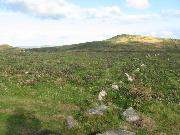
Foales Arrishes submitted by AngieLake : Walking over the ridge from Pil Tor towards Top Tor, this reave from Foale's Arrishes cut across the track. Rippon Tor in distance to SE. (Vote or comment on this photo)

Foales Arrishes
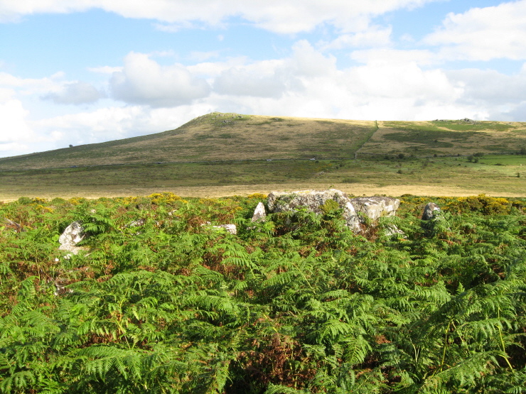
Foales Arrishes submitted by AngieLake : Standing at the NW wall looking across the centre of Hut 1, towards Rippon Tor, with the large stones forming the eastern side of the door above the prolific bracken. (1 comment - Vote or comment on this photo)

Foales Arrishes
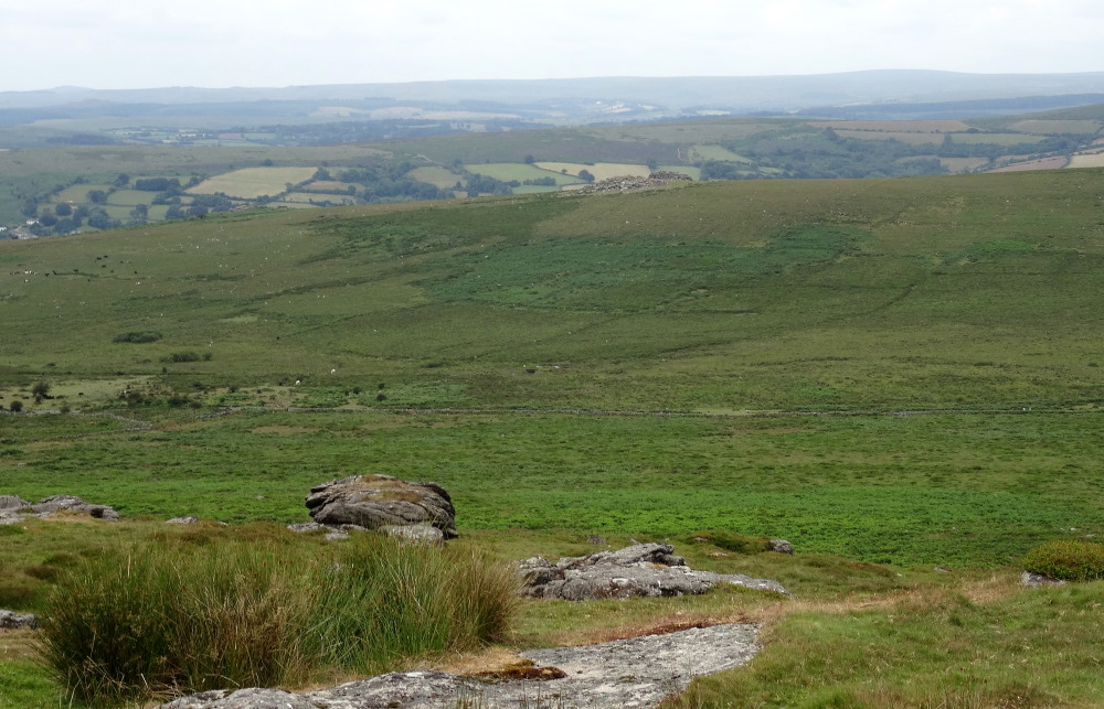
Foales Arrishes submitted by AngieLake : Not such a sunny day as October 2007 (similar photo at bottom of complete collection on site page), but attempted to enhance this to show the field details of view from Rippon Tor in July 2019. (Vote or comment on this photo)

Foales Arrishes
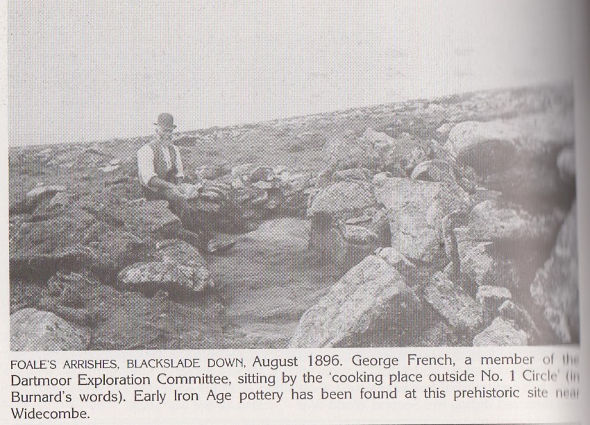
Foales Arrishes submitted by AngieLake : Antiquarian photo of the 'annexe' to Hut 1, described here as the 'cooking place'. From: 'From Haldon to Mid-Dartmoor in old photographs', collected by Tim Hall, published by Alan Sutton, 1990. (Vote or comment on this photo)

Foales Arrishes
Foales Arrishes submitted by AngieLake : A much-less bracken-covered Foales Arrishes in April 2017, with the stones of Hut 1 visible, centre, and Hut 2 rear left. This is the time to see the settlement at its best.

Foales Arrishes
Foales Arrishes submitted by AngieLake : View across bracken-free Hut 1 towards the summit of Rippon Tor on 8th April 2017.

Foales Arrishes
Foales Arrishes submitted by AngieLake : A view across Hut 1 without the bracken, on 8th April 2017. Looking towards the western slopes of Rippon Tor.

Foales Arrishes
Foales Arrishes submitted by AngieLake : Looking across Hut 1 towards Wittaburrow Hill with its summit cairn.

Foales Arrishes
Foales Arrishes submitted by AngieLake : Inside Hut 1 looking towards the south doorway, on 8th April 2017. This is the time to visit, when there's no bracken!

Foales Arrishes
Foales Arrishes submitted by AngieLake : Looking down on the 'annexe' outside the south wall of Hut 1, from the top of the wall, inside.

Foales Arrishes
Foales Arrishes submitted by AngieLake : The 'annexe' at the front of Hut 1, clearly seen without the bracken on 8th April 2017.

Foales Arrishes
Foales Arrishes submitted by AngieLake : Looking at the south door of Hut 1 on 8th April 2017. The 'annexe' to the left here.

Foales Arrishes
Foales Arrishes submitted by AngieLake : A view of Hut 2 without the bracken on 8th April 2017.

Foales Arrishes
Foales Arrishes submitted by AngieLake : Another view of Hut 2 on 8th April 2017.

Foales Arrishes
Foales Arrishes submitted by AngieLake : Hut 2 a bit easier to see on 8th April 2017.

Foales Arrishes
Foales Arrishes submitted by AngieLake : Wonderful display of lichen on the very large stone in the reave to west of Hut 1.

Foales Arrishes
Foales Arrishes submitted by AngieLake : This interesting early plan was copied from a Transactions of the Devon Association report of 1897, and reprinted in the 1926/7 publication of 'Druids or a Study in Celtic Prehistory', by T. D. Kendrick, which is currently being offered as a download on Meg P. It must be Hut 1, with the 'annexe'. The subject was temples of the Druids, and this is a short excerpt concerning circles not built as t...

Foales Arrishes
Foales Arrishes submitted by AngieLake : At this time of the day the lowering sun highlighted the banks by the upper cross-wall that was shown earlier (above hut 7 in plan?) “Cross banks built between the reaves formed rectangular fields surrounding the huts, ....”

Foales Arrishes
Foales Arrishes submitted by AngieLake : Coming down from Top Tor after 3hrs, around 6.30pm, this is the view approx south across Foale's Arrishes. It just looks a mesmerising jumble of stones! [I'd be further than top right of plan here.]

Foales Arrishes
Foales Arrishes submitted by AngieLake : Looking approx NW from the walls of Hut 4 towards Pil Tor, above.

Foales Arrishes
Foales Arrishes submitted by AngieLake : Looking down over the walls of Hut 4, described by Butler: “Hut 4 (5.5 m) lies on the opposite side of the reave and is a much less substantial building than the others. The wall is mainly a single line of stones, unlike neighbouring hut 3 which is double-slabbed. Excavation revealed no sign of occupation nor any finds.” (I wonder if it WAS a hut?)

Foales Arrishes
Foales Arrishes submitted by AngieLake : Looking over the walls of Hut 3, upper left of plan.

Foales Arrishes
Foales Arrishes submitted by AngieLake : I believe this was Hut 3, at upper left of plan. You can just see the top of the SE rock pile of Pil Tor peeking over the hill, upper right.

Foales Arrishes
Foales Arrishes submitted by AngieLake : Nearly at the end of the hut-hunt, this must be the enclosure of Hut 3, upper left of plan, the furthest west of the huts of Foale's Arrishes. You can see how distant Haytor and Saddle Tor are now. Quoting Butler: “The field associated with Hut 3 (7.1 m) is detached from the rest of the settlement. The gap in the reave opposite the hut may be the original entrance into the yard. The excavat...

These are just the first 25 photos of Foales Arrishes. If you log in with a free user account you will be able to see our entire collection.

Do not use the above information on other web sites or publications without permission of the contributor.
Click here to see more info for this site

Nearby sites

Click here to view sites on an interactive OS map

Key: Red: member's photo, Blue: 3rd party photo, Yellow: other image, Green: no photo - please go there and take one, Grey: site destroyed

Download sites to:
KML (Google Earth)
GPX (GPS waypoints)
CSV (Garmin/Navman)
CSV (Excel)

To unlock full downloads you need to sign up as a Contributory Member. Otherwise downloads are limited to 50 sites.


Turn off the page maps and other distractions

Nearby sites listing. In the following links * = Image available
 501m NE 43° Seven Lords' Lands* Stone Circle (SX74127623)
 507m SW 223° Blackslade Down Cairn and Cist* Cist (SX7341275510)
 584m W 261° Tunhill Rocks* Ancient Village or Settlement (SX7318975796)
 594m NNW 332° Top Tor row Stone Row / Alignment (SX735764)
 633m NNW 341° Top Tor Cairns* Cairn (SX7357476472)
 787m SSW 212° Wittaburrow Cairn* Cairn (SX73347521)
 934m ESE 107° Rippon Tor* Cairn (SX74667558)
 2.1km W 268° Dunstone Cup Stone Rock Art (SX71677585)
 2.2km WNW 294° Saxon Well* Holy Well or Sacred Spring (SX718768)
 2.5km NNW 339° Chinkwell Tor Cairn* Cairn (SX7293078250)
 2.6km S 183° Buckland Ridge South Ring Cairn (SX73577324)
 2.8km S 184° Ten Commandments Stone* Natural Stone / Erratic / Other Natural Feature (SX735731)
 2.9km N 5° Hound Tor Ring Cairn* Ring Cairn (SX7409778770)
 3.0km NE 36° Smallacombe Rocks Settlement* Ancient Village or Settlement (SX7558378211)
 3.0km S 184° Stidwell* Holy Well or Sacred Spring (SX735729)
 3.0km NNE 15° Hound Tor Deserted Medieval Village* Ancient Village or Settlement (SX74627878)
 3.1km N 8° Hound Tor Enclosure* Causewayed Enclosure (SX74307897)
 3.6km NE 50° Haytor Down Ring Cairn (SX76617814)
 3.7km NW 311° Hamel Down Cairn and Cist* Cairn (SX7100878345)
 3.8km NE 38° Black Hill Cairns* Cairn (SX762788)
 4.2km NW 315° Hamel Down Beacon cairn* Cairn (SX70837891)
 4.4km NW 315° Blackaton Down south (Hamel Down)* Cairn (SX70737904)
 4.4km NE 39° Trendlebere Down Stone Row Cairn* Cairn (SX7662079230)
 4.4km NE 38° Trendlebere Down* Multiple Stone Rows / Avenue (SX76627928)
 4.5km NW 315° Blackaton Down north (Hamel Down)* Cairn (SX70687909)
View more nearby sites and additional images

<< St Mary's Well (Charlcombe)

Tunhill Rocks >>

Please add your thoughts on this site

Prehistoric Settlements

Prehistoric Settlements

Sponsors

Auto-Translation (Google)

Translate from English into:

"Foales Arrishes" | Login/Create an Account | 6 News and Comments
  
Go back to top of page    Comments are owned by the poster. We aren't responsible for their content.
Re: Foales Arrishes - a visit on 8th April 2017 by AngieLake on Monday, 10 April 2017
(User Info | Send a Message)
Now is the time to visit this picturesque site. The bracken has been cut back and all the hut circles are exposed and their layout easy to appreciate. Visited on 8th April and took photos which I'll try to upload soon.
[ Reply to This ]

Re: Foales Arrishes - anvil stone in hut 1 by AngieLake on Monday, 27 August 2012
(User Info | Send a Message)
Butler writes (in his ‘Dartmoor Atlas of Antiquities, Volume Five – The Second Millennium B.C.’) on the subject of ‘Hut Interiors’ [pages 135-137]:
“Other less common features not entirely satisfactorily explained include ‘anvil’ stones, smallish flat or upended slabs embedded in the floor, either singly or in an arc around part of the interior. They were found in many of the Grimspound huts, in hut 1 Foale’s Arrishes and in hut 3 Smallacombe Rocks, the Committee suggesting they may have served either as a kind of chopping stone for breaking open bones, nuts, etc., or perhaps less likely as retainers for logs used as sleeping couches. Thirteen were found altogether at Shaugh Moor, both from the huts and elsewhere in the enclosure. Mrs Minter identified one of these stones in hut 2 Heatree Common, and at hut 3 Metherall , R.H. Worth showed that a similar earthfast slab had indeed been used as an anvil by the tinners, at least judging by the thick layer of tin slag that surrounded it."

I didn't see the anvil stone when visiting on 22nd August 2012, but the interior was pretty lush with bracken. Next time perhaps there'll be a photo of the anvil stone to add to the site page!
Interesting to see that Smallacombe Rocks' hut 3 had the same thing, so was this just a 'design-feature' in the area, or perhaps they were both involved in some kind of local processing work?
[ Reply to This ]

Re: Foales Arrishes - An aerial photograph by AngieLake on Monday, 27 August 2012
(User Info | Send a Message)
I found a great aerial photo of Foale's Arrishes on this website page:
http://www.lastrefuge.co.uk/php/show-images-all-big.php?id=DW2633
I hope this will still work, as it shows Adrian Warren's excellent shot which clearly shows the outline of two of the huts, which must surely be Hut 1 and Hut 2 (with its semicircular enclosure). It is copyright.
I haven't checked out his website yet.
[ Reply to This ]

Re: Foales Arrishes - Legendary Dartmoor link by AngieLake on Monday, 27 August 2012
(User Info | Send a Message)
http://www.legendarydartmoor.co.uk/hill_forts.htm

This is a very useful website with plenty of information on the Iron Age hillforts and settlements of Dartmoor. Foale's Arrishes is one of only six settlements shown on the moor during that period. Each site is listed under Name, Altitude, O.S. Grid Ref, ADS Record Number & Link, and type of Construction. Kestor is also mentioned.
[ Reply to This ]

Re: Foales Arrishes - a visit on 22nd August 2012 by AngieLake on Saturday, 25 August 2012
(User Info | Send a Message)
This site is actually easier to unravel when viewed from the top of Rippon Tor, to the ESE (pic already supplied). When walking along the lower SE contours of the tors (the ridge above Foale’s Arrishes is fairly level, and Pil Tor is approx SSW of Top Tor), you are met with a jumble of light-coloured stones, and a profusion of bracken. Somewhere in amongst all this are hut circles and walls of fields strung out between the older reaves. To help make sense of it, I hand-drew the plan in Butler’s ‘Dartmoor Atlas of Antiquites, Volume One – The East’*, published in 1991. The section on Foales Arrishes comes under Map 9, and starts on page 57. I took his book with me to try to locate some of the highlights of the site, and took many photos of those I believe I found. *(This set of five books is invaluable when exploring Dartmoor.) I parked at a little pull-in by the Widecombe road, just past Hemsworthy Gate, and right opposite Seven Lords’ Lands cairn. Foales’ Arrishes is very close to the road here.

First of all I had to smile at the mare and her foal idly munching grass near the footpath to Top Tor. We’ve all heard of the ‘Hound of the Baskerville’s’ - well this must have been the ‘Foal of Foale’s Arrishes’! He and his mum were still around when I returned over the top of the ridge 3 hours later.
Butler describes Foale’s Arrishes as “one of the most interesting settlement sites on Dartmoor, and at 300 m from the Widecombe to Haytor road comparatively easy to visit, though much of the site is under bracken during the summer.” (Oh, YES!)
“The settlement was laid out between the ends of a series of parallel reaves on the flatter ground around the head of Blackslade Water. Four of these reaves continue uphill to the west beyond Pil and Top Tors in the direction of Widecombe” while in the other direction they continue up over Rippon Tor.
“Cross banks built between the reaves formed rectangular fields surrounding thehuts, and short curved banks added outside to provide each with a small paddock or yard.” (Not exactly word-for-word.)
As the population increased the settlement expanded uphill. The distortion in the regular pattern near Huts 1 and 2 were caused during the constant repair and addition to walls.
The prehistoric site gets its current name from the last innkeeper, a ‘Mr Foale’, of the 18th century ‘New House’ inn, which once stood beside the Hemsorthy Gate to Cold East Cross road, and where a few low walls still remain. ‘Arrish’ is a Devonshire word for field, “particularly a corn field”.
Much of the wall stone of the site was removed by road-makers as noted by the Dartmoor Exploration Committee in 1896. The bottom right corner, the east section, has been removed as stated by Rev’d Croker, and towards the road, several truncated banks show where demolition has been more thorough.
Forming the earliest part of the settlement are the short and low parallel banks between Huts 1 and 4, marked Hi to Hiv, and orientated 17⁰ to the west. He shows a short section running at right-angles on the plan, at Hvii, and [NB] I omitted the ‘Hvi’ on the line of wall to the left of Hut 2.
All eight huts were excavated by the Dartmoor Exploration Committee in 1896 and a report was published in the Transactions of the Devonshire Association the following year. “The walls were mostly built of large slabs and some of the entrances are still visible.
“Hut 1 (9.5 m) is the largest and has the unusual feature of an annexe outside the entrance on the south. This is built of neatly coursed stone (though you can’t see that!), which suggests a later rebuild, though the excavators found a cooking hole, charcoal and pottery on the paved floor contemporary with that from the hut. The dwelling itself produced a piece of flint flake used as a knife and more pottery.”
“Hut 2 (6.1 m) is built into the wall of a semicircular enclosure 15 x 20 m across, into which th

Read the rest of this post...
[ Reply to This ]
    Re: Foales Arrishes - a visit on 22nd August 2012 by AngieLake on Thursday, 06 September 2012
    (User Info | Send a Message)
    Just a note on terrain: Contrary to the note about boggy-ness at top of page, I didn't find any patches of this during my walk in the above report. If you go further down the slope towards Blackslade Mire I'm sure those conditions will apply!
    [ Reply to This ]

Your Name: Anonymous [ Register Now ]
Subject:


Add your comment or contribution to this page. Spam or offensive posts are deleted immediately, don't even bother

<<< What is five plus one as a number? (Please type the answer to this question in the little box on the left)
You can also embed videos and other things. For Youtube please copy and paste the 'embed code'.
For Google Street View please include Street View in the text.
Create a web link like this: <a href="https://www.megalithic.co.uk">This is a link</a>  

Allowed HTML is:
<p> <b> <i> <a> <img> <em> <br> <strong> <blockquote> <tt> <li> <ol> <ul> <object> <param> <embed> <iframe>

We would like to know more about this location. Please feel free to add a brief description and any relevant information in your own language.
Wir möchten mehr über diese Stätte erfahren. Bitte zögern Sie nicht, eine kurze Beschreibung und relevante Informationen in Deutsch hinzuzufügen.
Nous aimerions en savoir encore un peu sur les lieux. S'il vous plaît n'hesitez pas à ajouter une courte description et tous les renseignements pertinents dans votre propre langue.
Quisieramos informarnos un poco más de las lugares. No dude en añadir una breve descripción y otros datos relevantes en su propio idioma.