

<< Our Photo Pages >> Carnedd Copa Arenig Fach - Cairn in Wales in Gwynedd
Submitted by TAlanJones on Wednesday, 17 May 2023 Page Views: 323
Neolithic and Bronze AgeSite Name: Carnedd Copa Arenig FachCountry: Wales County: Gwynedd Type: Cairn
Nearest Town: Bala Nearest Village: Frongoch
Map Ref: SH8203841599
Latitude: 52.958748N Longitude: 3.757529W
Condition:
| 5 | Perfect |
| 4 | Almost Perfect |
| 3 | Reasonable but with some damage |
| 2 | Ruined but still recognisable as an ancient site |
| 1 | Pretty much destroyed, possibly visible as crop marks |
| 0 | No data. |
| -1 | Completely destroyed |
| 5 | Superb |
| 4 | Good |
| 3 | Ordinary |
| 2 | Not Good |
| 1 | Awful |
| 0 | No data. |
| 5 | Can be driven to, probably with disabled access |
| 4 | Short walk on a footpath |
| 3 | Requiring a bit more of a walk |
| 2 | A long walk |
| 1 | In the middle of nowhere, a nightmare to find |
| 0 | No data. |
| 5 | co-ordinates taken by GPS or official recorded co-ordinates |
| 4 | co-ordinates scaled from a detailed map |
| 3 | co-ordinates scaled from a bad map |
| 2 | co-ordinates of the nearest village |
| 1 | co-ordinates of the nearest town |
| 0 | no data |
Internal Links:
External Links:
")
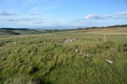
Situated on the copa (summit) of Arenig Fach mountain lies a large Bronze Age cairn. It is one of a pair with the other cairn some 40m to the NE. According to Coflein, NPRN 514738 ' the other cairn survived in a much better condition.... As this example has been truncated by the construction of a shelter and triangulation pillar.' Basically, Coflein's contention is that a previous implication made by RCAHMW Merioneth Inventory 467 in that, this cairn material was purely re-used material from the other cairn (Carnedd Y Bachgen) was inaccurate. Coflein goes on to describe the cairn as being 10m in diameter by 0.06m high, and insists that this cairn should not be confused or mistaken for the other cairn, i.e. Carnedd y Bachgen.
During my visit I was able to see Coflein's point. The cairn material spreads circularly around the current shelter, clearly emerging from the turf in an upward slant towards the centre. There's no discernable large kerbing but the basic shape suggests a large rocky mountain cairn that's common in Meirionydd.
Arenig Fach rises from the Migneint moorland it is a copa (peak/summit) of the Arenig range of mountains. From most directions it looks like a heathery lump. However, it's NE side is a series of steep cliffs with a small tarn called Llyn Arenig Fach at the base. It is a notoriously challenging ascent and descent with narrow heathery paths and hidden holes, and the summit does not provide for much of a respite until you reach the trig point and shelter. I destroyed my mountain trainers during this visit.(see pic) luckily I always carry a spare pair.
The views from the copa are wonderful with a 360 degree mountain fest and life suddenly seems that little less stressful ... Until you start your descent 😲
You may be viewing yesterday's version of this page. To see the most up to date information please register for a free account.
")
")
")
")
")
Do not use the above information on other web sites or publications without permission of the contributor.
Click here to see more info for this site
Nearby sites
Key: Red: member's photo, Blue: 3rd party photo, Yellow: other image, Green: no photo - please go there and take one, Grey: site destroyed
Download sites to:
KML (Google Earth)
GPX (GPS waypoints)
CSV (Garmin/Navman)
CSV (Excel)
To unlock full downloads you need to sign up as a Contributory Member. Otherwise downloads are limited to 50 sites.
Turn off the page maps and other distractions
Nearby sites listing. In the following links * = Image available
22m E 86° Carnedd Y Bachgen* Round Cairn (SH8206041600)
1.5km E 100° Bryn Du Cairn* Cairn (SH8346841315)
1.7km E 91° Clogwyn Du Kerb Cairn* Cairn (SH8378341522)
1.8km E 93° Clogwyn Du Cairn* Cairn (SH8388141462)
2.5km SW 223° Pont Tai Hirion Ancient Bridge* Ancient Trackway (SH803398)
2.5km SW 222° Afon Taihirion Standing Stone* Standing Stone (Menhir) (SH80303976)
3.1km WSW 245° Nant yr Olchfa Cairn* Round Cairn (SH7919140367)
3.3km WSW 242° Nant yr Olchfa Hut Circle* Ancient Village or Settlement (SH79104012)
3.9km WSW 254° Carnedd Iago Stones* Standing Stone (Menhir) (SH7826840651)
3.9km WSW 253° Carnedd Iago Cairn* Cairn (SH7826340522)
4.4km NW 315° Migneint Mile Slate Slab* Marker Stone (SH78984480)
4.5km SE 124° Llidiardau* Standing Stone (Menhir) (SH857390)
4.5km SE 127° Ffridd Felen* Cairn (SH856388)
4.7km S 171° Moel yr Eglwys* Cairn (SH82703695)
4.8km E 91° Pen Garneddwen Cairn* Cairn (SH868414)
5.6km E 100° Hafod Fadog Memorial* Modern Stone Circle etc (SH87594049)
5.9km WSW 246° Afon Prysor Cairn* Cairn (SH766393)
5.9km NW 323° Bryniau Duon Cairn near Llyn Conwy* Cairn (SH786464)
5.9km NW 320° Llyn Conwy Island Cairn* Cairn (SH783462)
6.1km NW 312° Bryn Owen Cairn* Cairn (SH776458)
6.2km WNW 288° Ffynnon Eidda* Holy Well or Sacred Spring (SH762437)
7.3km SSE 163° Moel Ymenyn Cairn* Cairn (SH840346)
7.3km N 359° Ysbyty Pont Blaen Eidda Cairn* Cairn (SH82064895)
7.4km W 272° Llyn Dubach Hut Circle* Ancient Village or Settlement (SH7458642048)
7.6km SSE 159° Cairn East of Moel Ymenyn* Cairn (SH846344)
View more nearby sites and additional images


 We would like to know more about this location. Please feel free to add a brief description and any relevant information in your own language.
 Wir möchten mehr über diese Stätte erfahren. Bitte zögern Sie nicht, eine kurze Beschreibung und relevante Informationen in Deutsch hinzuzufügen.
 Nous aimerions en savoir encore un peu sur les lieux. S'il vous plaît n'hesitez pas à ajouter une courte description et tous les renseignements pertinents dans votre propre langue.
 Quisieramos informarnos un poco más de las lugares. No dude en añadir una breve descripción y otros datos relevantes en su propio idioma.