


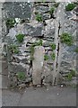
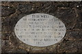
<< Our Photo Pages >> St Gudula's Well - Holy Well or Sacred Spring in England in Devon
Submitted by KiwiBetsy on Tuesday, 12 September 2006 Page Views: 7975
Springs and Holy WellsSite Name: St Gudula's Well Alternative Name: GulwellCountry: England
NOTE: This site is 0.604 km away from the location you searched for.
County: Devon Type: Holy Well or Sacred Spring
Nearest Town: Ashburton
Map Ref: SX754694
Latitude: 50.511094N Longitude: 3.758653W
Condition:
| 5 | Perfect |
| 4 | Almost Perfect |
| 3 | Reasonable but with some damage |
| 2 | Ruined but still recognisable as an ancient site |
| 1 | Pretty much destroyed, possibly visible as crop marks |
| 0 | No data. |
| -1 | Completely destroyed |
| 5 | Superb |
| 4 | Good |
| 3 | Ordinary |
| 2 | Not Good |
| 1 | Awful |
| 0 | No data. |
| 5 | Can be driven to, probably with disabled access |
| 4 | Short walk on a footpath |
| 3 | Requiring a bit more of a walk |
| 2 | A long walk |
| 1 | In the middle of nowhere, a nightmare to find |
| 0 | No data. |
| 5 | co-ordinates taken by GPS or official recorded co-ordinates |
| 4 | co-ordinates scaled from a detailed map |
| 3 | co-ordinates scaled from a bad map |
| 2 | co-ordinates of the nearest village |
| 1 | co-ordinates of the nearest town |
| 0 | no data |
Internal Links:
External Links:
I have visited· I would like to visit
cazzyjane has visited here
")
You may be viewing yesterday's version of this page. To see the most up to date information please register for a free account.
")
")
Do not use the above information on other web sites or publications without permission of the contributor.
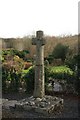
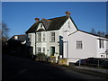
Nearby Images from Geograph Britain and Ireland:
©2019(licence)
©2010(licence)
©2010(licence)
©2008(licence)

©2019(licence)
The above images may not be of the site on this page, they are loaded from Geograph.
Please Submit an Image of this site or go out and take one for us!
Click here to see more info for this site
Nearby sites
Key: Red: member's photo, Blue: 3rd party photo, Yellow: other image, Green: no photo - please go there and take one, Grey: site destroyed
Download sites to:
KML (Google Earth)
GPX (GPS waypoints)
CSV (Garmin/Navman)
CSV (Excel)
To unlock full downloads you need to sign up as a Contributory Member. Otherwise downloads are limited to 50 sites.
Turn off the page maps and other distractions
Nearby sites listing. In the following links * = Image available
2.9km WSW 250° Hembury Castle* Hillfort (SX7263868449)
4.0km NNW 330° Stidwell* Holy Well or Sacred Spring (SX735729)
4.2km NNW 332° Ten Commandments Stone* Natural Stone / Erratic / Other Natural Feature (SX735731)
4.3km NNW 333° Buckland Ridge South Ring Cairn (SX73577324)
6.2km NNW 339° Wittaburrow Cairn* Cairn (SX73347521)
6.2km N 352° Rippon Tor* Cairn (SX74667558)
6.2km E 97° Denbury* Hillfort (SX816685)
6.4km NNW 341° Blackslade Down Cairn and Cist* Cist (SX7341275510)
6.4km ESE 108° Three Holes Cave Cave or Rock Shelter (SX815673)
6.5km ESE 106° Brokern Cavern Cave or Rock Shelter (SX81596748)
6.5km ESE 107° Tornewton Cave Cave or Rock Shelter (SX816674)
6.7km NNW 345° Foales Arrishes* Ancient Village or Settlement (SX73777587)
6.7km SW 228° Skerraton Down Round Cairn (SX703650)
6.7km W 273° Holne Lee* Ring Cairn (SX68666992)
6.8km NNW 340° Tunhill Rocks* Ancient Village or Settlement (SX7318975796)
6.9km NNW 348° Seven Lords' Lands* Stone Circle (SX74127623)
7.1km SW 232° Harbourne Head Standing Stone* Standing Stone (Menhir) (SX69686509)
7.3km NNW 343° Top Tor row Stone Row / Alignment (SX735764)
7.3km NNW 344° Top Tor Cairns* Cairn (SX7357476472)
7.3km WNW 300° Sherberton Common Multiple Stone Rows / Avenue (SX691732)
7.4km NNW 329° Dunstone Cup Stone Rock Art (SX71677585)
7.6km WNW 286° Holne Moor North Ring Cairn (SX68097162)
7.6km SW 233° Harbourne Head B* Ring Cairn (SX6914265001)
7.6km SW 234° Harbourne Head A* Ring Cairn (SX6911765034)
7.8km WSW 239° Gripper's Hill Cairn Circle* Ring Cairn (SX68656550)
View more nearby sites and additional images


 We would like to know more about this location. Please feel free to add a brief description and any relevant information in your own language.
 Wir möchten mehr über diese Stätte erfahren. Bitte zögern Sie nicht, eine kurze Beschreibung und relevante Informationen in Deutsch hinzuzufügen.
 Nous aimerions en savoir encore un peu sur les lieux. S'il vous plaît n'hesitez pas à ajouter une courte description et tous les renseignements pertinents dans votre propre langue.
 Quisieramos informarnos un poco más de las lugares. No dude en añadir una breve descripción y otros datos relevantes en su propio idioma.