 with our Megalithic Portal iPhone app")

<< Our Photo Pages >> Lochrutton Loch - Crannog in Scotland in Dumfries and Galloway
Submitted by markj99 on Thursday, 25 May 2023 Page Views: 496
Iron Age and Later PrehistorySite Name: Lochrutton LochCountry: Scotland
NOTE: This site is 3.502 km away from the location you searched for.
County: Dumfries and Galloway Type: Crannog
Nearest Town: Dumfries Nearest Village: Lochfoot
Map Ref: NX89837299
Latitude: 55.039171N Longitude: 3.725506W
Condition:
| 5 | Perfect |
| 4 | Almost Perfect |
| 3 | Reasonable but with some damage |
| 2 | Ruined but still recognisable as an ancient site |
| 1 | Pretty much destroyed, possibly visible as crop marks |
| 0 | No data. |
| -1 | Completely destroyed |
| 5 | Superb |
| 4 | Good |
| 3 | Ordinary |
| 2 | Not Good |
| 1 | Awful |
| 0 | No data. |
| 5 | Can be driven to, probably with disabled access |
| 4 | Short walk on a footpath |
| 3 | Requiring a bit more of a walk |
| 2 | A long walk |
| 1 | In the middle of nowhere, a nightmare to find |
| 0 | No data. |
| 5 | co-ordinates taken by GPS or official recorded co-ordinates |
| 4 | co-ordinates scaled from a detailed map |
| 3 | co-ordinates scaled from a bad map |
| 2 | co-ordinates of the nearest village |
| 1 | co-ordinates of the nearest town |
| 0 | no data |
Internal Links:
External Links:
I have visited· I would like to visit
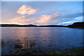
markj99 visited on 24th May 2023 - their rating: Cond: 2 Amb: 4 Access: 4 Lochrutton Loch Crannog is not spectacular, however, it is an easy walk on a path to view the crannog from the E bank of the loch.
Directions: Take the Lochfoot turn off the A75 at the Drummore Roundabout c. 3 miles W of Dumfries. After c. 0.7 mile you will reach a crossroads. Continue straight onto an unsigned narrow road for c. 0.3 miles to reach a lay-by on the left. A path for Lochrutton Loch starts here, heading W along a fence. As the path heads through a dry stane dyke turn left, heading S through the field towards a wooded promontory on the loch edge. The path continues W along the promontory for c. 100 yards to the water's edge. The crannog is a small isle in the middle of the loch, populated by several small trees, SW of the promontory. My walk can be viewed on Lochrutton Loch.
")
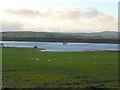
Lochrutton Loch Crannog is located in the centre of Lochrutton Loch in DumfrIes and Galloway. The loch is immediately S of Lochfoot, a small village c. 5 miles WSW of Dumfries. The crannog is visible as tree-covered island in the middle of Lochrutton Loch, c. 270 yards NE from the end of a promontory on the E bank of the loch. According to Canmore ID 65031 the sub circular island has a 24m diameter. The submerged remains of the crannog measure c. 40m at a depth of 3m. The crannog is built on a mound of small boulders supported by horizontal and vertical timbers. There is a scattering of dislodged wood on the loch bed.
You may be viewing yesterday's version of this page. To see the most up to date information please register for a free account.
")
Do not use the above information on other web sites or publications without permission of the contributor.
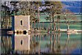
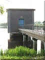
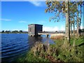
Nearby Images from Geograph Britain and Ireland:
©2007(licence)
©2008(licence)
©2006(licence)
©2007(licence)
©2013(licence)
The above images may not be of the site on this page, they are loaded from Geograph.
Please Submit an Image of this site or go out and take one for us!
Click here to see more info for this site
Nearby sites
Key: Red: member's photo, Blue: 3rd party photo, Yellow: other image, Green: no photo - please go there and take one, Grey: site destroyed
Download sites to:
KML (Google Earth)
GPX (GPS waypoints)
CSV (Garmin/Navman)
CSV (Excel)
To unlock full downloads you need to sign up as a Contributory Member. Otherwise downloads are limited to 50 sites.
Turn off the page maps and other distractions
Nearby sites listing. In the following links * = Image available
2.3km ENE 66° Easthill* Stone Circle (NX91937388)
3.8km NNE 23° Beacon Hill (Dumfries and Galloway)* Hillfort (NX91397643)
4.9km NW 323° The Doons* Hillfort (NX86987699)
5.3km NNE 32° Ladye Well (Terregles) Holy Well or Sacred Spring (NX92767744)
5.3km NNW 331° Angel Well (Barnsoul) Holy Well or Sacred Spring (NX87337770)
5.6km E 97° Picts Knowe* Henge (NX95387213)
5.8km E 96° St Queran's Well* Holy Well or Sacred Spring (NX95597222)
5.8km WSW 251° Milton Loch SE* Crannog (NX84287120)
6.0km WSW 258° Milton Loch NW* Crannog (NX83887188)
6.1km WSW 254° Milton Loch Central* Crannog (NX83947149)
6.1km WSW 256° Green Island (Milton Loch)* Misc. Earthwork (NX83857164)
6.3km ENE 69° Troqueer Cursus Cursus (NX95837512)
6.5km N 5° Hall Hill* Hillfort (NX90597949)
6.6km ENE 69° Troqueer Cursus Cursus (NX96137517)
6.8km SSW 207° St Winning's Well (Kirkgunzeon)* Holy Well or Sacred Spring (NX86526699)
7.1km SSW 206° Kirkgunzeon Stone Circle (NX86576668)
7.2km NNE 12° Holywood Cursus Cursus (NX91558004)
7.6km ENE 68° Dumfries Museum* Museum (NX9698975731)
7.9km ENE 68° St Allan's Wells (Dumfries) Holy Well or Sacred Spring (NX97307576)
8.0km NE 36° Twelve Apostles (Dumfries)* Stone Circle (NX9470079400)
8.3km NE 37° Holywood A Cursus Cursus (NX94937951)
8.4km NE 35° Holywood A Cursus Cursus (NX94857979)
8.6km NE 35° Holywood B Cursus Cursus (NX949799)
8.7km ENE 68° Greystone Park Stone Circle (NX980760)
8.9km NE 35° Holywood B Cursus Cursus (NX951802)
View more nearby sites and additional images


 We would like to know more about this location. Please feel free to add a brief description and any relevant information in your own language.
 Wir möchten mehr über diese Stätte erfahren. Bitte zögern Sie nicht, eine kurze Beschreibung und relevante Informationen in Deutsch hinzuzufügen.
 Nous aimerions en savoir encore un peu sur les lieux. S'il vous plaît n'hesitez pas à ajouter une courte description et tous les renseignements pertinents dans votre propre langue.
 Quisieramos informarnos un poco más de las lugares. No dude en añadir una breve descripción y otros datos relevantes en su propio idioma.