

<< Our Photo Pages >> Caer Garn Cairn and Round Barrow - Barrow Cemetery in Wales in Conwy
Submitted by TAlanJones on Thursday, 06 July 2023 Page Views: 202
Neolithic and Bronze AgeSite Name: Caer Garn Cairn and Round Barrow Alternative Name: Afon Ceirw CairnCountry: Wales
NOTE: This site is 2.524 km away from the location you searched for.
County: Conwy Type: Barrow Cemetery
Nearest Town: Cerrigydrudion
Map Ref: SH8897047270
Latitude: 53.011186N Longitude: 3.65633W
Condition:
| 5 | Perfect |
| 4 | Almost Perfect |
| 3 | Reasonable but with some damage |
| 2 | Ruined but still recognisable as an ancient site |
| 1 | Pretty much destroyed, possibly visible as crop marks |
| 0 | No data. |
| -1 | Completely destroyed |
| 5 | Superb |
| 4 | Good |
| 3 | Ordinary |
| 2 | Not Good |
| 1 | Awful |
| 0 | No data. |
| 5 | Can be driven to, probably with disabled access |
| 4 | Short walk on a footpath |
| 3 | Requiring a bit more of a walk |
| 2 | A long walk |
| 1 | In the middle of nowhere, a nightmare to find |
| 0 | No data. |
| 5 | co-ordinates taken by GPS or official recorded co-ordinates |
| 4 | co-ordinates scaled from a detailed map |
| 3 | co-ordinates scaled from a bad map |
| 2 | co-ordinates of the nearest village |
| 1 | co-ordinates of the nearest town |
| 0 | no data |
Internal Links:
External Links:
")
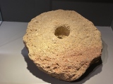
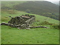
The recording by Coflein, see NPRN 40551 refers to this site as the Afon Ceirw Cairn and describes a once visible 12m diameter cairn prior to 1951, before it was levelled. The OS maps continue to include the site further confusing the enthusiastic cairn hunter. Furthermore, the Gwynedd Archaeological Trust not only identify this cairn but also suggest the previously apparent location of a round barrow but a few metres away at SH8900047210.
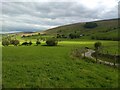
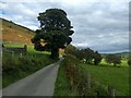
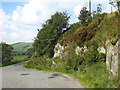
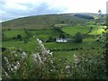
This is an environment with an undulating terrain. The Afon Ceirw and Nant y Pentre rivers meander through a cwm (valley) surrounded by high hills that range between 400 and 550m in height before ascending to the higher mounts such as Carnedd y Filiast of the northern Arenig range. Perfect for cairn hunting.
Alas I can confirm that very little remains of either site. However, I did note a stone at the cairn site, and a passing cyclist waved at me 😊
You may be viewing yesterday's version of this page. To see the most up to date information please register for a free account.
")
")
")
")
Do not use the above information on other web sites or publications without permission of the contributor.
Nearby Images from Geograph Britain and Ireland:
©2024(licence)
©2024(licence)
©2008(licence)
©2008(licence)
©2024(licence)
The above images may not be of the site on this page, they are loaded from Geograph.
Please Submit an Image of this site or go out and take one for us!
Click here to see more info for this site
Nearby sites
Key: Red: member's photo, Blue: 3rd party photo, Yellow: other image, Green: no photo - please go there and take one, Grey: site destroyed
Download sites to:
KML (Google Earth)
GPX (GPS waypoints)
CSV (Garmin/Navman)
CSV (Excel)
To unlock full downloads you need to sign up as a Contributory Member. Otherwise downloads are limited to 50 sites.
Turn off the page maps and other distractions
Nearby sites listing. In the following links * = Image available
1.4km NNE 15° Garn Prys* Cairn (SH89374866)
1.7km NE 46° Cefnhirfynydd Uchaf Cairn 3* Cairn (SH9024848454)
1.9km NE 38° Cefnhirfynydd Uchaf Cairnfield* Barrow Cemetery (SH9016648725)
1.9km ENE 66° Moel Eglwys Cairn* Cairn (SH9071348011)
2.0km NNE 32° Cefnhirfynydd Uchaf Standing Stone* Standing Stone (Menhir) (SH9004348910)
2.1km NE 46° Cefnhirfynydd Uchaf Cairn 2* Cairn (SH9054048710)
2.1km NE 39° Cefnhirfynydd Uchaf Enclosure* Ancient Village or Settlement (SH9037148889)
2.2km NE 46° Cefnhirfynydd Uchaf Cairn 1* Cairn (SH9056048725)
3.5km N 6° Carreg Nanw* Modern Stone Circle etc (SH8940550794)
4.7km NNW 337° Lon Mynydd Hiraethog* Ancient Trackway (SH8719051650)
5.7km NNW 337° Carreg Nant Y Foel* Natural Stone / Erratic / Other Natural Feature (SH8690152540)
6.2km NNW 347° Hafod Y Garreg Earthworks and Cairns* Barrow Cemetery (SH8773053360)
6.2km N 349° Hafod Y Garreg Cist* Cist (SH8790053400)
6.3km SSW 199° Pen Garneddwen Cairn* Cairn (SH868414)
6.3km N 349° Hafod Y Carreg Cairn Field* Barrow Cemetery (SH8793053470)
6.3km NNW 348° Hafod y Garreg Row* Stone Row / Alignment (SH87815345)
6.3km NNW 349° Ffridd Can Awen Cists* Cist (SH8786053480)
6.5km N 355° Hafod y Dre* Stone Row / Alignment (SH88535371)
6.5km NNW 348° Ffridd Can Awen Cairn* Cairn (SH8774053620)
6.7km N 350° Cefnen Wen Cairn Field* Barrow Cemetery (SH8796053890)
6.7km E 83° Cronglwyd Fawr Barrow* Round Barrow(s) (SH9565047940)
6.9km N 10° Bwlch y Garnedd Hut Circle* Ancient Village or Settlement (SH90305401)
6.9km S 190° Hafod Fadog Memorial* Modern Stone Circle etc (SH87594049)
6.9km N 353° Cefnen Wen Cairn East* Cairn (SH8824054160)
6.9km N 352° Cefnen Wen Cairn and Cist* Cairn (SH8817054170)
View more nearby sites and additional images


 We would like to know more about this location. Please feel free to add a brief description and any relevant information in your own language.
 Wir möchten mehr über diese Stätte erfahren. Bitte zögern Sie nicht, eine kurze Beschreibung und relevante Informationen in Deutsch hinzuzufügen.
 Nous aimerions en savoir encore un peu sur les lieux. S'il vous plaît n'hesitez pas à ajouter une courte description et tous les renseignements pertinents dans votre propre langue.
 Quisieramos informarnos un poco más de las lugares. No dude en añadir una breve descripción y otros datos relevantes en su propio idioma.