


<< Our Photo Pages >> Williamcraigs Standing Stone - Natural Stone / Erratic / Other Natural Feature in Scotland in East Lothian
Submitted by Andy B on Thursday, 06 May 2021 Page Views: 913
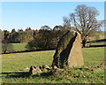
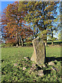
Date UncertainSite Name: Williamcraigs Standing Stone Alternative Name: The Witches Stone, The Devils StoneCountry: Scotland
NOTE: This site is 2.335 km away from the location you searched for.
County: East Lothian Type: Natural Stone / Erratic / Other Natural Feature
Map Ref: NS99037544
Latitude: 55.961323N Longitude: 3.618939W
Condition:
| 5 | Perfect |
| 4 | Almost Perfect |
| 3 | Reasonable but with some damage |
| 2 | Ruined but still recognisable as an ancient site |
| 1 | Pretty much destroyed, possibly visible as crop marks |
| 0 | No data. |
| -1 | Completely destroyed |
| 5 | Superb |
| 4 | Good |
| 3 | Ordinary |
| 2 | Not Good |
| 1 | Awful |
| 0 | No data. |
| 5 | Can be driven to, probably with disabled access |
| 4 | Short walk on a footpath |
| 3 | Requiring a bit more of a walk |
| 2 | A long walk |
| 1 | In the middle of nowhere, a nightmare to find |
| 0 | No data. |
| 5 | co-ordinates taken by GPS or official recorded co-ordinates |
| 4 | co-ordinates scaled from a detailed map |
| 3 | co-ordinates scaled from a bad map |
| 2 | co-ordinates of the nearest village |
| 1 | co-ordinates of the nearest town |
| 0 | no data |
Internal Links:
External Links:
")
Information from Stan Hughes, who writes: the stone seems as if it has been there for a very long time, it is surrounded by some ‘cairn-like’ stones and is located on the top of a natural rise in the field.
Canmore link
You may be viewing yesterday's version of this page. To see the most up to date information please register for a free account.
")
Do not use the above information on other web sites or publications without permission of the contributor.
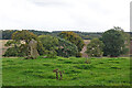
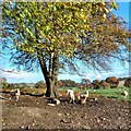
Nearby Images from Geograph Britain and Ireland:
©2023(licence)
©2023(licence)
©2023(licence)
©2021(licence)
©2021(licence)
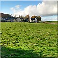
The above images may not be of the site on this page, they are loaded from Geograph.
Please Submit an Image of this site or go out and take one for us!
Click here to see more info for this site
Nearby sites
Key: Red: member's photo, Blue: 3rd party photo, Yellow: other image, Green: no photo - please go there and take one, Grey: site destroyed
Download sites to:
KML (Google Earth)
GPX (GPS waypoints)
CSV (Garmin/Navman)
CSV (Excel)
To unlock full downloads you need to sign up as a Contributory Member. Otherwise downloads are limited to 50 sites.
Turn off the page maps and other distractions
Nearby sites listing. In the following links * = Image available
1.1km S 184° Cockleroy Hill (Beecraigs)* Hillfort (NS98947438)
1.6km S 177° Kipps Farm* Round Cairn (NS99087387)
1.6km N 349° The Boarstane (Linlithgow) Standing Stone (Menhir) (NS98757706)
2.1km NNE 33° Cross Well (Linlithgow)* Holy Well or Sacred Spring (NT0021677170)
2.5km SSW 201° Gormyre* Standing Stone (Menhir) (NS98067311)
2.7km S 177° Craigmailing Boundary Marker (Torphichen)* Marker Stone (NS99097270)
3.2km S 186° Lower Craigmailing (Torphichen)* Ancient Cross (NS98627222)
3.3km ESE 120° Beecraigs Round Cairn (NT01827372)
3.7km SW 215° Torphichen Churchyard Stone* Standing Stone (Menhir) (NS96847250)
3.7km S 183° Cairnpapple Hill* Round Cairn (NS98727175)
4.1km S 177° Knock Stone Circle* Modern Stone Circle etc (NS99137133)
5.6km S 181° Galabraes* Standing Stone (Menhir) (NS9881869839)
5.7km SW 233° Westfield Farm Refuge Stone* Early Christian Sculptured Stone (NS94377211)
5.8km SW 215° North Couston Refuge Stone* Early Christian Sculptured Stone (NS95637078)
8.6km SW 228° Hillhouse (Torphichen) Standing Stone (Menhir) (NS92456984)
9.3km ENE 75° Justice Stone Standing Stone (Menhir) (NT08087759)
9.8km ENE 67° Abercorn Sculptured Stone (NT08147910)
9.8km SW 221° Boar Stone (Armadale)* Natural Stone / Erratic / Other Natural Feature (NS92336820)
10.7km WNW 293° Marion's Well (Falkirk) Holy Well or Sacred Spring (NS89267977)
11.8km NNE 18° Tuilyies* Standing Stones (NT02918658)
12.8km NNW 339° Gubber Hill Standing Stone (Menhir) (NS948875)
13.4km WNW 288° Watling Lodge, Antonine Wall* Ancient Village or Settlement (NS86347982)
13.4km NNW 333° Market Cross (Kincardine)* Ancient Cross (NS9312087515)
13.6km E 101° Huly Hill Standing Stones* Standing Stones (NT1234272610)
13.6km E 101° Huly Hill Cairn* Round Cairn (NT1234272610)
View more nearby sites and additional images


 We would like to know more about this location. Please feel free to add a brief description and any relevant information in your own language.
 Wir möchten mehr über diese Stätte erfahren. Bitte zögern Sie nicht, eine kurze Beschreibung und relevante Informationen in Deutsch hinzuzufügen.
 Nous aimerions en savoir encore un peu sur les lieux. S'il vous plaît n'hesitez pas à ajouter une courte description et tous les renseignements pertinents dans votre propre langue.
 Quisieramos informarnos un poco más de las lugares. No dude en añadir una breve descripción y otros datos relevantes en su propio idioma.