


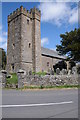
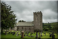
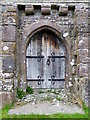
<< Our Photo Pages >> St David's Church, Llywel - Marker Stone in Wales in Powys
Submitted by jfarrar on Saturday, 20 October 2012 Page Views: 5198
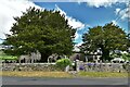
Multi-periodSite Name: St David's Church, LlywelCountry: Wales County: Powys Type: Marker Stone
Nearest Town: Sennybridge Nearest Village: Llywel
Map Ref: SN86953005
Latitude: 51.957407N Longitude: 3.6466W
Condition:
| 5 | Perfect |
| 4 | Almost Perfect |
| 3 | Reasonable but with some damage |
| 2 | Ruined but still recognisable as an ancient site |
| 1 | Pretty much destroyed, possibly visible as crop marks |
| 0 | No data. |
| -1 | Completely destroyed |
| 5 | Superb |
| 4 | Good |
| 3 | Ordinary |
| 2 | Not Good |
| 1 | Awful |
| 0 | No data. |
| 5 | Can be driven to, probably with disabled access |
| 4 | Short walk on a footpath |
| 3 | Requiring a bit more of a walk |
| 2 | A long walk |
| 1 | In the middle of nowhere, a nightmare to find |
| 0 | No data. |
| 5 | co-ordinates taken by GPS or official recorded co-ordinates |
| 4 | co-ordinates scaled from a detailed map |
| 3 | co-ordinates scaled from a bad map |
| 2 | co-ordinates of the nearest village |
| 1 | co-ordinates of the nearest town |
| 0 | no data |
Internal Links:
External Links:
")
There is also a cast of the Llywel Pillar Stone, a 5th century memorial stone, the original of which is in the British Museum and another copy is in Brecknock Museum, Brecon
You may be viewing yesterday's version of this page. To see the most up to date information please register for a free account.
")
Do not use the above information on other web sites or publications without permission of the contributor.
Nearby Images from Geograph Britain and Ireland:
©2013(licence)
©2016(licence)
©2017(licence)
©2010(licence)
©2021(licence)
The above images may not be of the site on this page, they are loaded from Geograph.
Please Submit an Image of this site or go out and take one for us!
Click here to see more info for this site
Nearby sites
Key: Red: member's photo, Blue: 3rd party photo, Yellow: other image, Green: no photo - please go there and take one, Grey: site destroyed
Download sites to:
KML (Google Earth)
GPX (GPS waypoints)
CSV (Garmin/Navman)
CSV (Excel)
To unlock full downloads you need to sign up as a Contributory Member. Otherwise downloads are limited to 50 sites.
Turn off the page maps and other distractions
Nearby sites listing. In the following links * = Image available
881m NE 50° Varlen Cairn* Cairn (SN87643060)
943m SSW 204° Tyle Mawr* Cairn (SN86542920)
1.9km NNW 330° Blaen Clydach Fach Cairn 1* Cairn (SN86043170)
2.0km NNW 331° Blaen Clydach Fach Cairn 2* Cairn (SN86003185)
2.3km W 268° Pant Madog Cairn* Round Barrow(s) (SN84623003)
3.7km WNW 284° Y Pigwn standing stone* Standing Stone (Menhir) (SN83423103)
3.7km WNW 285° Trecastle Mountain ENE* Stone Circle (SN83343109)
3.8km WNW 284° Trecastle Mountain WSW* Stone Circle (SN83313107)
3.8km WNW 284° Trecastle Mountain Row* Stone Row / Alignment (SN8327331053)
3.9km WNW 285° Pigwn Stone Circle 3* Stone Circle (SN83203117)
3.9km WNW 282° Y Pigwn cairn 2* Cairn (SN83143098)
3.9km W 259° Cwm Henwen Cairn* Cairn (SN83082939)
4.0km WSW 243° Gwern-Wyddog* Standing Stone (Menhir) (SN833283)
4.0km WNW 285° Y Pigwn cairn 1* Cairn (SN83063119)
4.1km WSW 258° Cwm Henwen* Standing Stone (Menhir) (SN82962929)
5.0km W 280° Waun Ddu Roman Fortlet* Hillfort (SN82063104)
5.1km W 275° Pen y Bylchau Round Barrow Barrow Cemetery (SN81853065)
5.2km W 274° Mynydd Myddfai Barrow* Round Barrow(s) (SN818305)
5.2km WNW 282° Trecastle Hill Mile stone* Standing Stones (SN8190631211)
5.5km SW 216° Troed Rhiw Wen standing stone* Standing Stone (Menhir) (SN83602567)
5.6km W 277° Cwm y Cadno Standing Stone* Standing Stone (Menhir) (SN81393084)
5.7km E 94° Coed Gibraltar* Promontory Fort / Cliff Castle (SN92622954)
5.7km W 265° Mynydd Myddfai Round Barrow* Barrow Cemetery (SN8123429678)
5.7km W 265° Pant-y-Ddwyros Cairn* Round Barrow(s) (SN81232968)
5.8km W 269° Pen y Bylchau Bronze Age Enclosure* Hillfort (SN81153006)
View more nearby sites and additional images


 We would like to know more about this location. Please feel free to add a brief description and any relevant information in your own language.
 Wir möchten mehr über diese Stätte erfahren. Bitte zögern Sie nicht, eine kurze Beschreibung und relevante Informationen in Deutsch hinzuzufügen.
 Nous aimerions en savoir encore un peu sur les lieux. S'il vous plaît n'hesitez pas à ajouter une courte description et tous les renseignements pertinents dans votre propre langue.
 Quisieramos informarnos un poco más de las lugares. No dude en añadir una breve descripción y otros datos relevantes en su propio idioma.