<< Our Photo Pages >> Holy Trinity Well (Rackenford) - Holy Well or Sacred Spring in England in Devon
Submitted by AngieLake on Thursday, 03 January 2019 Page Views: 1344
Springs and Holy WellsSite Name: Holy Trinity Well (Rackenford) Alternative Name: Trinity Well (Rackenford); Holy Trinity WellCountry: England
NOTE: This site is 0.15 km away from the location you searched for.
County: Devon Type: Holy Well or Sacred Spring
Nearest Town: Tiverton Nearest Village: Rackenford
Map Ref: SS85001825
Latitude: 50.952174N Longitude: 3.638574W
Condition:
| 5 | Perfect |
| 4 | Almost Perfect |
| 3 | Reasonable but with some damage |
| 2 | Ruined but still recognisable as an ancient site |
| 1 | Pretty much destroyed, possibly visible as crop marks |
| 0 | No data. |
| -1 | Completely destroyed |
| 5 | Superb |
| 4 | Good |
| 3 | Ordinary |
| 2 | Not Good |
| 1 | Awful |
| 0 | No data. |
| 5 | Can be driven to, probably with disabled access |
| 4 | Short walk on a footpath |
| 3 | Requiring a bit more of a walk |
| 2 | A long walk |
| 1 | In the middle of nowhere, a nightmare to find |
| 0 | No data. |
| 5 | co-ordinates taken by GPS or official recorded co-ordinates |
| 4 | co-ordinates scaled from a detailed map |
| 3 | co-ordinates scaled from a bad map |
| 2 | co-ordinates of the nearest village |
| 1 | co-ordinates of the nearest town |
| 0 | no data |
Internal Links:
External Links:

Listed as a holy well on Devon & Dartmoor HER.
HER Number: MDV12316
Name: Holy Trinity Well
Summary: Holy Trinity Well near Holy Trinity Church in Rackenford where the water was used to treat eye troubles.
Location
Grid ref: SS 850 182 (Angie thinks this is more like SS 8500 1825, but posting up will show)
Map Sheet: SS81NE
Admin Area: Devon
Civil Parish: Rackenford
District: North Devon
Ecclesiastical Parish: Rackenford
Old DCC SMR Ref: SS81NE/19
Monument Type(s) and Dates: HOLY WELL (Unknown date).**
Ordnance Survey, 1880s, Ordance Survey (Cartographic). SDV848
" 'Holy Trinity Well' shown on OS 25" (1880s & 1905) maps as a small circle with a larger circular feature c10m diameter across the road to the north (see PRN 71634). The well is shown to the northwest of 'Holy Trinity Church' (which has since changed its name to All Saints Church) in Rackenford. Other details: Also on OS 25" (1905) map.
[Check out website for three books with sources of info on this well.]
http://www.heritagegateway.org.uk/Gateway/Results_Single.aspx?uid=MDV12316&resourceID=104
Another well at Rackenford is mentioned on the above website:
"HER Number: MDV12312"
"Ordnance Survey Archaeology Division, SS81NW8 (Ordnance Survey Archaeology Division Card). SDV60156."
"Brown cites a saint's well 'on Rackenford Common. ' OS uncertain if this is the one mentioned. OS 6" 1887 (revised 1903) shows a well at above NGR. The sacred well is marked at SS85021826 (see PRN 12316)."
"Brown, T., 1958 - 1959, Holy and Notable Wells of Devon, III, 37 (Article in Serial). SDV60158.
"Holy well on Rackenford common according to John Benson with unknown dedication."
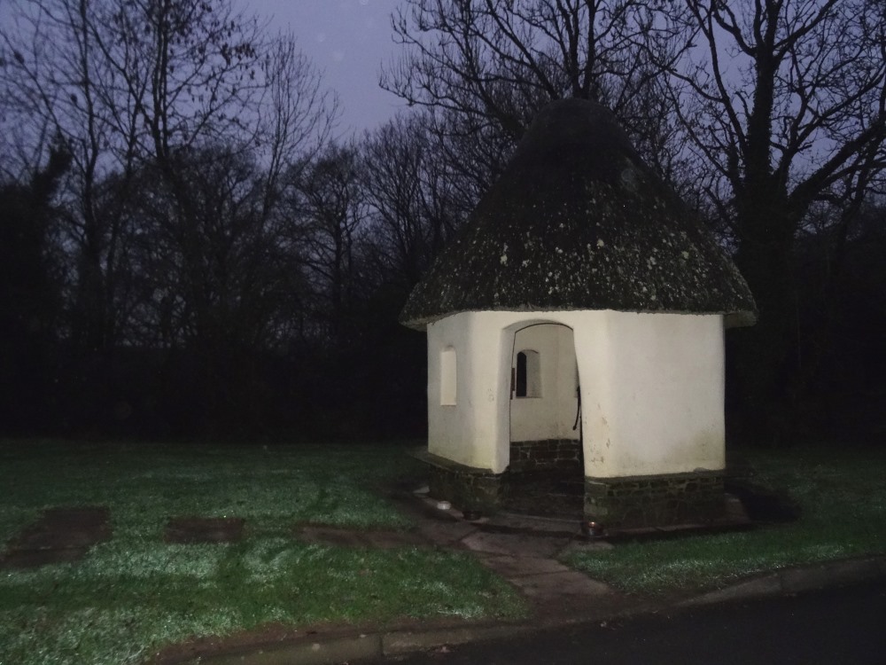
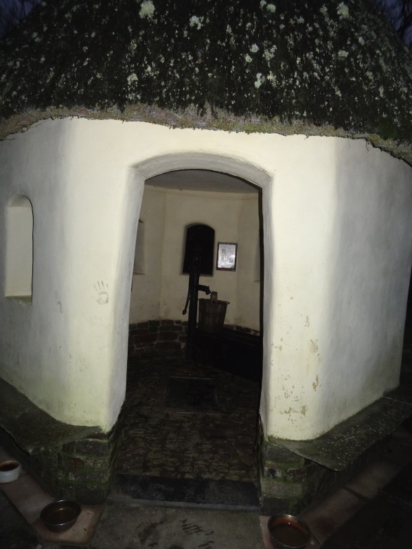
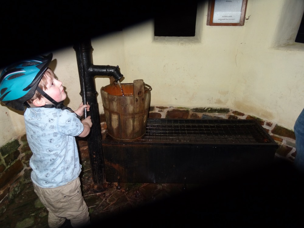
I came across this well while visiting the village late on Friday 28th December 2018, finding references to it in the nearby church. (That ref said it was 'south' of the church, but obviously not.) The information panel in the little round building that protects it shows an old photo of the same well, so it must be the correct site. A family had just entered the building before my cousin and I did, and their young son was having a great time using the pump, which still works today. The actual water was covered over by a glass panel, and it was too dim at around 4.15pm to see anything, and I didn't have a torch on me. From the point of view of seeing the well itself, the ambience was not great, but the little building was lovely. It was a rushed visit, and unfortunately my photo of the info poster was not clear, so I've tried to tweak it a bit, to show where the reference is to 'Holy Well' and 'eye problems'.
Checking nearby sites we have on Meg P, it is NE of Berry Castle.
In these pages: http://freepages.rootsweb.com/~footprints1/genealogy/dev1/rackenford/homepage.htm
we read that
"Rackenford is an old village and small parish approximately 8 miles north-east of Tiverton and 12 miles north of Crediton. It is a parish made up of many scattered farms and dwellings. The parish was mentioned in the Domesday Book in 1086 as Racheneforda which is believed to mean "a ford suitable for riding by a river or stream". "
** If it was included in the Domesday Book it may have been an important well at those times?
You may be viewing yesterday's version of this page. To see the most up to date information please register for a free account.


Do not use the above information on other web sites or publications without permission of the contributor.
Click here to see more info for this site
Nearby sites
Key: Red: member's photo, Blue: 3rd party photo, Yellow: other image, Green: no photo - please go there and take one, Grey: site destroyed
Download sites to:
KML (Google Earth)
GPX (GPS waypoints)
CSV (Garmin/Navman)
CSV (Excel)
To unlock full downloads you need to sign up as a Contributory Member. Otherwise downloads are limited to 50 sites.
Turn off the page maps and other distractions
Nearby sites listing. In the following links * = Image available
1.9km SW 231° Berry Castle (Devon)* Hillfort (SS835171)
3.1km S 173° Witheridge Moor Barrows* Barrow Cemetery (SS853152)
3.9km NNW 336° Knowstone Inner Moor Round Barrow(s) (SS8346021869)
4.3km NW 323° Beaples Hill* Standing Stone (Menhir) (SS8248621693)
7.8km WSW 251° Long Stone (East Worlington)* Standing Stone (Menhir) (SS77511587)
8.7km E 89° Castle Close* Misc. Earthwork (SS937182)
8.8km W 264° Meshaw Moor (West)* Round Barrow(s) (SS762175)
10.1km SSW 207° Berry Castle (Black Dog)* Hillfort (SS802093)
10.9km N 1° West Anstey Barrows* Barrow Cemetery (SS85452918)
11.2km N 358° West Anstey Long Stone* Standing Stone (Menhir) (SS84932942)
11.6km NNE 29° Oldberry Castle Hillfort (SS90932820)
11.8km NNE 16° Mounsey Castle Hillfort (SS88562955)
12.0km NNE 15° Brewer's Castle Hillfort (SS88332977)
12.2km WSW 241° Burridge Ancient Settlement* Ancient Village or Settlement (SS742126)
12.3km NW 310° Garliford Hillfort (SS757263)
12.5km W 279° St. Rumon's well* Holy Well or Sacred Spring (SS727205)
12.6km ESE 119° Cranmore Castle Hillfort (SS959119)
14.0km N 6° Tarr Steps Prehistoric Bridge* Ancient Trackway (SS86773211)
14.1km E 90° Huntsham Castle* Misc. Earthwork (SS99111784)
14.2km ESE 106° Craze Lowman Mound* Round Barrow(s) (SS98611399)
14.4km SSE 153° Cadbury Castle (Devon)* Hillfort (SS913053)
14.8km NNW 341° Twitchen barrows* Barrow Cemetery (SS804323)
15.5km WNW 298° South Molton Museum* Museum (SS7142125848)
15.5km SSE 166° Raddon Hill* Causewayed Enclosure (SS885031)
15.8km NNE 13° Caratacus Stone* Standing Stone (Menhir) (SS88973355)
View more nearby sites and additional images


 We would like to know more about this location. Please feel free to add a brief description and any relevant information in your own language.
 Wir möchten mehr über diese Stätte erfahren. Bitte zögern Sie nicht, eine kurze Beschreibung und relevante Informationen in Deutsch hinzuzufügen.
 Nous aimerions en savoir encore un peu sur les lieux. S'il vous plaît n'hesitez pas à ajouter une courte description et tous les renseignements pertinents dans votre propre langue.
 Quisieramos informarnos un poco más de las lugares. No dude en añadir una breve descripción y otros datos relevantes en su propio idioma.