

<< Text Pages >> Llyn Aled Isaf - Ancient Village or Settlement in Wales in Denbighshire
Submitted by coldrum on Wednesday, 27 July 2011 Page Views: 5493
Mesolithic, Palaeolithic and EarlierSite Name: Llyn Aled IsafCountry: Wales
NOTE: This site is 0.145 km away from the location you searched for.
County: Denbighshire Type: Ancient Village or Settlement
Map Ref: SH91295959
Latitude: 53.122363N Longitude: 3.625932W
Condition:
| 5 | Perfect |
| 4 | Almost Perfect |
| 3 | Reasonable but with some damage |
| 2 | Ruined but still recognisable as an ancient site |
| 1 | Pretty much destroyed, possibly visible as crop marks |
| 0 | No data. |
| -1 | Completely destroyed |
| 5 | Superb |
| 4 | Good |
| 3 | Ordinary |
| 2 | Not Good |
| 1 | Awful |
| 0 | No data. |
| 5 | Can be driven to, probably with disabled access |
| 4 | Short walk on a footpath |
| 3 | Requiring a bit more of a walk |
| 2 | A long walk |
| 1 | In the middle of nowhere, a nightmare to find |
| 0 | No data. |
| 5 | co-ordinates taken by GPS or official recorded co-ordinates |
| 4 | co-ordinates scaled from a detailed map |
| 3 | co-ordinates scaled from a bad map |
| 2 | co-ordinates of the nearest village |
| 1 | co-ordinates of the nearest town |
| 0 | no data |
Internal Links:
External Links:
Mesolithic occupation site in Denbighshire (Sir Ddinbych)
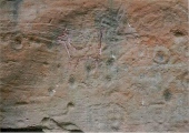
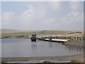
Drought conditions at the reservoir of Llyn Aled Isaf in 1974 revealed Mesolithic occupation which was further investigated in 1989. The site revealed a series of possible campsites marked by stakeholes, hearths and a substantial flint scatter. It appears to have been visited repeatedly. No stratigraphic evidence survives with the finds. Most appear to belong to the Late Mesolithic (c.7500-4000 Cal BC) but recent analysis of the assemblage has shown that it also contains an Early Mesolithic component (c.9200-7500 Cal BC) (2).
A consideration of the local landscape suggests that the attraction of the area to early hunters lay in the deep river trench (now flooded) which was suitable for trapping game. The environment was perhaps less densely wooded than the surrounding lowlands and the climate gentler making the uplands less bleak than today.
Soil analysis indicated farming activity and soil erosion in later prehistory.
Source: Coflein
You may be viewing yesterday's version of this page. To see the most up to date information please register for a free account.
Do not use the above information on other web sites or publications without permission of the contributor.
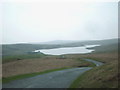
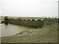
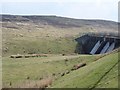
Nearby Images from Geograph Britain and Ireland:
©2011(licence)
©2005(licence)
©2006(licence)
©2006(licence)
©2011(licence)
The above images may not be of the site on this page, they are loaded from Geograph.
Please Submit an Image of this site or go out and take one for us!
Click here to see more info for this site
Nearby sites
Key: Red: member's photo, Blue: 3rd party photo, Yellow: other image, Green: no photo - please go there and take one, Grey: site destroyed
Download sites to:
KML (Google Earth)
GPX (GPS waypoints)
CSV (Garmin/Navman)
CSV (Excel)
To unlock full downloads you need to sign up as a Contributory Member. Otherwise downloads are limited to 50 sites.
Turn off the page maps and other distractions
Nearby sites listing. In the following links * = Image available
296m NE 44° Aled Isaf Reservoir Standing Stone* Standing Stone (Menhir) (SH915598)
2.7km NNE 12° Boncyn Crwn Barrow* Round Barrow(s) (SH9192062170)
2.9km ENE 62° Blaen y Cwm Barrow* Round Barrow(s) (SH93916091)
3.3km ENE 70° Rhiwiau Barrow* Round Barrow(s) (SH94466063)
3.8km NNE 18° Cau Du Barrow* Round Barrow(s) (SH9256063160)
4.1km WNW 296° Gwytherin Churchyard* Stone Row / Alignment (SH87676147)
4.2km S 173° Lon Bwlch y Garnedd Trackway* Ancient Trackway (SH9170055450)
4.3km SSE 164° Nant Heilyn* Ring Cairn (SH92355543)
4.4km S 176° Bwlch y Garnedd Cairn 1* Cairn (SH91475517)
4.6km NNW 342° Rhos Domen Barrow Cemetery (SH900640)
4.7km S 185° Bwlch y Garnedd Round Cairn* Round Cairn (SH90755494)
4.7km SSW 208° Pen Yr Orsedd Ring Cairn* Ring Cairn (SH8901055460)
5.1km SSW 213° Moel Rhiwlug Cairn 1* Cairn (SH88445538)
5.1km S 185° Bwlch y Garnedd Cairn 3 Cairn (SH90695450)
5.4km SSW 213° Moel Rhiwlug Cairn 2* Cairn (SH88295515)
5.4km SSW 209° Moel Rhiwlug Recumbent* Natural Stone / Erratic / Other Natural Feature (SH8855954892)
5.5km S 187° Lon Bwlch y Garnedd standing stones* Standing Stones (SH9046154197)
5.5km S 188° Bwlch y Garnedd Menhir Standing Stone (Menhir) (SH9045254194)
5.5km E 88° Gorsedd Bran* Barrow Cemetery (SH968597)
5.6km SSW 208° Bryniau Duon Cairn on Hiraethog Trail* Cairn (SH8855054670)
5.7km S 189° Bwlch y Garnedd Hut Circle* Ancient Village or Settlement (SH90305401)
6.2km SSW 208° Cefnen Wen Cairn East* Cairn (SH8824054160)
6.2km SSW 209° Cefnen Wen Cairn and Cist* Cairn (SH8817054170)
6.5km SSW 204° Hafod y Dre* Stone Row / Alignment (SH88535371)
6.6km SSW 209° Cefnen Wen Cairn Field* Barrow Cemetery (SH8796053890)
View more nearby sites and additional images


 We would like to know more about this location. Please feel free to add a brief description and any relevant information in your own language.
 Wir möchten mehr über diese Stätte erfahren. Bitte zögern Sie nicht, eine kurze Beschreibung und relevante Informationen in Deutsch hinzuzufügen.
 Nous aimerions en savoir encore un peu sur les lieux. S'il vous plaît n'hesitez pas à ajouter une courte description et tous les renseignements pertinents dans votre propre langue.
 Quisieramos informarnos un poco más de las lugares. No dude en añadir una breve descripción y otros datos relevantes en su propio idioma.