 with our Megalithic Portal iPhone app")


<< Our Photo Pages >> Ladywell (Abbotskerswell) - Holy Well or Sacred Spring in England in Devon
Submitted by KiwiBetsy on Tuesday, 29 August 2006 Page Views: 7746
Springs and Holy WellsSite Name: Ladywell (Abbotskerswell)Country: England
NOTE: This site is 0.315 km away from the location you searched for.
County: Devon Type: Holy Well or Sacred Spring
Nearest Town: Abbotskerswell
Map Ref: SX858684
Latitude: 50.504228N Longitude: 3.611735W
Condition:
| 5 | Perfect |
| 4 | Almost Perfect |
| 3 | Reasonable but with some damage |
| 2 | Ruined but still recognisable as an ancient site |
| 1 | Pretty much destroyed, possibly visible as crop marks |
| 0 | No data. |
| -1 | Completely destroyed |
| 5 | Superb |
| 4 | Good |
| 3 | Ordinary |
| 2 | Not Good |
| 1 | Awful |
| 0 | No data. |
| 5 | Can be driven to, probably with disabled access |
| 4 | Short walk on a footpath |
| 3 | Requiring a bit more of a walk |
| 2 | A long walk |
| 1 | In the middle of nowhere, a nightmare to find |
| 0 | No data. |
| 5 | co-ordinates taken by GPS or official recorded co-ordinates |
| 4 | co-ordinates scaled from a detailed map |
| 3 | co-ordinates scaled from a bad map |
| 2 | co-ordinates of the nearest village |
| 1 | co-ordinates of the nearest town |
| 0 | no data |
Internal Links:
External Links:
I have visited· I would like to visit
Mabel_Smith would like to visit
 (PID:23634)")
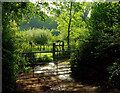
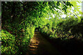
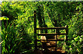
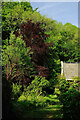
This well is located on a bridleway which runs to the right of the Butcher’s Arms Inn. It is about 100 yards up the bridleway.
You may be viewing yesterday's version of this page. To see the most up to date information please register for a free account.
 (PID:23635)")
Do not use the above information on other web sites or publications without permission of the contributor.
Nearby Images from Geograph Britain and Ireland:
©2022(licence)
©2022(licence)
©2021(licence)
©2022(licence)
©2022(licence)
The above images may not be of the site on this page, they are loaded from Geograph.
Please Submit an Image of this site or go out and take one for us!
Click here to see more info for this site
Nearby sites
Key: Red: member's photo, Blue: 3rd party photo, Yellow: other image, Green: no photo - please go there and take one, Grey: site destroyed
Download sites to:
KML (Google Earth)
GPX (GPS waypoints)
CSV (Garmin/Navman)
CSV (Excel)
To unlock full downloads you need to sign up as a Contributory Member. Otherwise downloads are limited to 50 sites.
Turn off the page maps and other distractions
Nearby sites listing. In the following links * = Image available
1.6km W 262° Dornafield Tumulus* Round Barrow(s) (SX842682)
2.2km SSW 205° Ipplepen Iron Age Settlement* Ancient Village or Settlement (SX848664)
2.9km NNW 334° Newton Abbot Fort Hillfort (SX846710)
2.9km NNE 15° Newton Abbot Museum* Museum (SX866712)
2.9km E 81° Doda Well* Holy Well or Sacred Spring (SX887688)
3.0km ENE 59° Milber Down Camp* Hillfort (SX884699)
4.2km W 270° Denbury* Hillfort (SX816685)
4.3km WSW 256° Brokern Cavern Cave or Rock Shelter (SX81596748)
4.3km WSW 255° Tornewton Cave Cave or Rock Shelter (SX816674)
4.4km WSW 254° Three Holes Cave Cave or Rock Shelter (SX815673)
6.9km ESE 109° Stonehenge at Babbacombe Model Village* Modern Stone Circle etc (SX923660)
8.1km SE 125° Torquay Museum* Museum (SX9232863616)
8.5km NE 39° Whitewell Woods Well* Holy Well or Sacred Spring (SX913749)
8.7km ESE 118° Kent's Cavern* Cave or Rock Shelter (SX93456418)
9.7km SSW 213° The Brutus Stone* Marker Stone (SX8035760411)
9.7km SSW 213° Totnes Museum* Museum (SX8030060419)
10.0km SW 215° Leech Wells* Holy Well or Sacred Spring (SX799603)
10.1km NE 39° Lidwell* Holy Well or Sacred Spring (SX924761)
10.3km N 3° Pixie's Hole Cave or Rock Shelter (SX86547865)
10.3km N 2° Cow Cave Cave or Rock Shelter (SX86477866)
10.4km W 274° St Gudula's Well* Holy Well or Sacred Spring (SX754694)
10.4km N 8° Castle Dyke (Chudleigh)* Hillfort (SX875787)
10.7km NE 35° Castle Dyke (Devon)* Ancient Village or Settlement (SX92147700)
10.9km NNW 338° St Mary's Well (Bovey Tracey)* Holy Well or Sacred Spring (SX820786)
11.3km NNW 336° The Bovey Stone Ancient Cross (SX8141778843)
View more nearby sites and additional images


 We would like to know more about this location. Please feel free to add a brief description and any relevant information in your own language.
 Wir möchten mehr über diese Stätte erfahren. Bitte zögern Sie nicht, eine kurze Beschreibung und relevante Informationen in Deutsch hinzuzufügen.
 Nous aimerions en savoir encore un peu sur les lieux. S'il vous plaît n'hesitez pas à ajouter une courte description et tous les renseignements pertinents dans votre propre langue.
 Quisieramos informarnos un poco más de las lugares. No dude en añadir una breve descripción y otros datos relevantes en su propio idioma.