 with our Megalithic Portal iPhone app")


<< Our Photo Pages >> Mynydd-y-Gaer - Hillfort in Wales in Denbighshire
Submitted by postman on Tuesday, 30 October 2012 Page Views: 5748
Iron Age and Later PrehistorySite Name: Mynydd-y-GaerCountry: Wales County: Denbighshire Type: Hillfort
Nearest Town: Abergele Nearest Village: Llanefydd
Map Ref: SH973718
Latitude: 53.233270N Longitude: 3.540086W
Condition:
| 5 | Perfect |
| 4 | Almost Perfect |
| 3 | Reasonable but with some damage |
| 2 | Ruined but still recognisable as an ancient site |
| 1 | Pretty much destroyed, possibly visible as crop marks |
| 0 | No data. |
| -1 | Completely destroyed |
| 5 | Superb |
| 4 | Good |
| 3 | Ordinary |
| 2 | Not Good |
| 1 | Awful |
| 0 | No data. |
| 5 | Can be driven to, probably with disabled access |
| 4 | Short walk on a footpath |
| 3 | Requiring a bit more of a walk |
| 2 | A long walk |
| 1 | In the middle of nowhere, a nightmare to find |
| 0 | No data. |
| 5 | co-ordinates taken by GPS or official recorded co-ordinates |
| 4 | co-ordinates scaled from a detailed map |
| 3 | co-ordinates scaled from a bad map |
| 2 | co-ordinates of the nearest village |
| 1 | co-ordinates of the nearest town |
| 0 | no data |
Internal Links:
External Links:
")
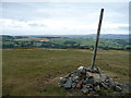
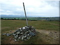
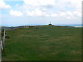
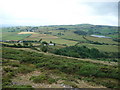
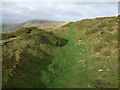
There's a quite steep side, and a gentle sloping side, like a twerp I went up the long steep way. The defences on the western side are the best preserved, with no really obvious entrances, but the views are terrific.
Situated amongst a maze of small lanes halfway between Snowdonia and the Clwydian range .
You may be viewing yesterday's version of this page. To see the most up to date information please register for a free account.
")
")
")
")
Do not use the above information on other web sites or publications without permission of the contributor.
Nearby Images from Geograph Britain and Ireland:
©2010(licence)
©2010(licence)
©2008(licence)
©2010(licence)
©2007(licence)
The above images may not be of the site on this page, they are loaded from Geograph.
Please Submit an Image of this site or go out and take one for us!
Click here to see more info for this site
Nearby sites
Key: Red: member's photo, Blue: 3rd party photo, Yellow: other image, Green: no photo - please go there and take one, Grey: site destroyed
Download sites to:
KML (Google Earth)
GPX (GPS waypoints)
CSV (Garmin/Navman)
CSV (Excel)
To unlock full downloads you need to sign up as a Contributory Member. Otherwise downloads are limited to 50 sites.
Turn off the page maps and other distractions
Nearby sites listing. In the following links * = Image available
3.3km E 98° Nant-Y-Graig Cave or Rock Shelter (SJ00567130)
3.5km ENE 78° Tyddyn Bleiddyn* Chambered Cairn (SJ00727246)
3.6km E 98° Bontnewydd Cave* Cave or Rock Shelter (SJ009712)
3.8km E 86° Tan-y-graig Stone Row / Alignment (SJ01137199)
3.9km N 4° St George's Well (Denbighshire) Holy Well or Sacred Spring (SH97657567)
3.9km N 351° Dinorben Hillfort (SH968757)
4.4km NNE 12° Terfyn Well Holy Well or Sacred Spring (SH98317613)
5.2km ESE 103° Cefn-Yr-Ogof Cave or Rock Shelter (SJ023705)
5.7km E 96° Ffynnon Fair (Trefnant)* Holy Well or Sacred Spring (SJ02927107)
5.9km SSW 205° Plas Newydd Barrow* Round Barrow(s) (SH94716644)
6.2km NW 323° Castel Cawr* Hillfort (SH937768)
6.5km ESE 113° Plas Heaton Cave Cave or Rock Shelter (SJ03206911)
7.5km NW 307° Pen-y-Corddyn-Mawr* Hillfort (SH914765)
7.6km NNW 336° Abergele Submerged Forest Not Known (by us) (SH9442278805)
8.2km N 4° Kinmel Bay Boundary Stone Marker Stone (SH980800)
9.8km SSW 207° Cau Du Barrow* Round Barrow(s) (SH9256063160)
9.9km NNE 12° Rhyl Submerged Forest* Natural Stone / Erratic / Other Natural Feature (SH9959081409)
10.0km NE 45° Ffynnon Fair (Rhuddlan)* Holy Well or Sacred Spring (SJ045788)
10.7km SW 222° Rhos Domen Barrow Cemetery (SH900640)
10.7km WSW 245° St Digain (Llangernyw)* Ancient Cross (SH8749567455)
10.7km WSW 250° Ffynnon Digain* Holy Well or Sacred Spring (SH87146833)
11.0km E 86° St Beuno's Well (Tremeirchion)* Holy Well or Sacred Spring (SJ083723)
11.0km SSW 208° Boncyn Crwn Barrow* Round Barrow(s) (SH9192062170)
11.1km NE 47° Dyserth Church* Ancient Cross (SJ056792)
11.1km E 85° Cae Gwyn* Cave or Rock Shelter (SJ0843972501)
View more nearby sites and additional images


 We would like to know more about this location. Please feel free to add a brief description and any relevant information in your own language.
 Wir möchten mehr über diese Stätte erfahren. Bitte zögern Sie nicht, eine kurze Beschreibung und relevante Informationen in Deutsch hinzuzufügen.
 Nous aimerions en savoir encore un peu sur les lieux. S'il vous plaît n'hesitez pas à ajouter une courte description et tous les renseignements pertinents dans votre propre langue.
 Quisieramos informarnos un poco más de las lugares. No dude en añadir una breve descripción y otros datos relevantes en su propio idioma.