


<< Our Photo Pages >> Whitewell Woods Well - Holy Well or Sacred Spring in England in Devon
Submitted by Maia on Thursday, 08 July 2010 Page Views: 14641
Springs and Holy WellsSite Name: Whitewell Woods Well Alternative Name: White WellCountry: England
NOTE: This site is 1.358 km away from the location you searched for.
County: Devon Type: Holy Well or Sacred Spring
Nearest Town: Teignmouth Nearest Village: Bishopsteignton
Map Ref: SX913749
Latitude: 50.563709N Longitude: 3.536105W
Condition:
| 5 | Perfect |
| 4 | Almost Perfect |
| 3 | Reasonable but with some damage |
| 2 | Ruined but still recognisable as an ancient site |
| 1 | Pretty much destroyed, possibly visible as crop marks |
| 0 | No data. |
| -1 | Completely destroyed |
| 5 | Superb |
| 4 | Good |
| 3 | Ordinary |
| 2 | Not Good |
| 1 | Awful |
| 0 | No data. |
| 5 | Can be driven to, probably with disabled access |
| 4 | Short walk on a footpath |
| 3 | Requiring a bit more of a walk |
| 2 | A long walk |
| 1 | In the middle of nowhere, a nightmare to find |
| 0 | No data. |
| 5 | co-ordinates taken by GPS or official recorded co-ordinates |
| 4 | co-ordinates scaled from a detailed map |
| 3 | co-ordinates scaled from a bad map |
| 2 | co-ordinates of the nearest village |
| 1 | co-ordinates of the nearest town |
| 0 | no data |
Internal Links:
External Links:
I have visited· I would like to visit
Mabel_Smith visited on 26th Nov 2018 - their rating: Cond: 2 Amb: 4 Access: 2 Very easy to find if you go in from the small car park rather than through the woods, the best path from Bishopsteignton is via the steep public footpath on the corner of Berry Hill and Teignview Road. Follow this path all the way to the road at the top of the hill and go right towards the golf course until you reach the Gypsy Corner sign post, carry on to the right until you see a height restricting barrier marking the entrance to the car park on the right. Pass through the car park towards the information board and take the footpath passing a picnic bench on your left, DON'T follow the sign guiding you to the left, keep to the right down the hill where there are two overgrown paths leading into the woods. Both paths will get you there, the left path is straighter but steeper and more overgrown whereas the right path is windier and uneven. The ground around the well is uneven and muddy so take care and wear your wellies! Interestingly the ground here is full of white flint, possibly the source of the name White Well. Despite the awful damage done by vandals a few years ago to the stonework of the well and Victorian pump house, the atmosphere here is rather lovely, a good place to contemplate in peace, I will bring a folding chair next time so I can meditate for longer.
")
The unusual 'mushroom' design housing was constructed above the surface to protect and gather the natural spring water supply that bubbles up through white sand from the water table under Little Haldon Hill. There are 7 springs that emerge from the Hill, most with well housings from different eras.
The construction is local red sandstone shaped to fit the circular design. A topping stone used to be present, and was said to be white. Old pictures show it to be similar to a used mill stone made from grit stone, and may be recycled from the Bishop's many farming activities. If the stone is used for flour grinding in an upright rolling position, it would wear away to the shape as seen in old photos.
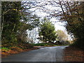
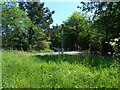
Access is allowed because although it is on private land, it is a Public Right of Way. Best path into the woods is from Council owned car park 'Whitewells' easily found near to Teignmouth Golf Course. Car height restrictions are in force. From the car park descend the steep hill on the left hand side of the woods, after about 150m take the only main level track to the right. The Well and now ruined Pump House are on the left hand side of this path after about 100m.
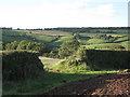
Other features of interest in this fabulous deciduous woodland are earthworks, said to be C19th flint quarries, but we think they are much older. There are also banks resembling neolithic construction, leading to an iron age fort, and there are small burial mounds 'incorporated' in the nearby golf course....
Damage by vandals has been a great cause for concern in 2010 as this is increasing the likelihood of complete ruin to both the well and a nearby C19th pump house.
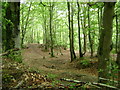
This site is still well worth visiting, and advice and guidance on restoration of the buildings will be gladly received. It is a delightful small natural woodland within a huge area of FC conifer planting, and as such is a wildlife haven, with rare Devon tree species.
Note: Serious vandalism to the structure of this well, see photo
You may be viewing yesterday's version of this page. To see the most up to date information please register for a free account.
")
Do not use the above information on other web sites or publications without permission of the contributor.
Nearby Images from Geograph Britain and Ireland:
©2009(licence)
©2010(licence)
©2009(licence)
©2009(licence)
©2023(licence)
The above images may not be of the site on this page, they are loaded from Geograph.
Please Submit an Image of this site or go out and take one for us!
Click here to see more info for this site
Nearby sites
Key: Red: member's photo, Blue: 3rd party photo, Yellow: other image, Green: no photo - please go there and take one, Grey: site destroyed
Download sites to:
KML (Google Earth)
GPX (GPS waypoints)
CSV (Garmin/Navman)
CSV (Excel)
To unlock full downloads you need to sign up as a Contributory Member. Otherwise downloads are limited to 50 sites.
Turn off the page maps and other distractions
Nearby sites listing. In the following links * = Image available
1.6km NE 41° Lidwell* Holy Well or Sacred Spring (SX924761)
2.3km NNE 21° Castle Dyke (Devon)* Ancient Village or Settlement (SX92147700)
5.4km NW 314° Castle Dyke (Chudleigh)* Hillfort (SX875787)
5.8km SSW 209° Milber Down Camp* Hillfort (SX884699)
6.0km SW 231° Newton Abbot Museum* Museum (SX866712)
6.0km NW 307° Pixie's Hole Cave or Rock Shelter (SX86547865)
6.1km NW 307° Cow Cave Cave or Rock Shelter (SX86477866)
6.6km SSW 202° Doda Well* Holy Well or Sacred Spring (SX887688)
7.7km WSW 239° Newton Abbot Fort Hillfort (SX846710)
8.5km SW 219° Ladywell (Abbotskerswell)* Holy Well or Sacred Spring (SX858684)
9.0km S 172° Stonehenge at Babbacombe Model Village* Modern Stone Circle etc (SX923660)
9.7km SW 225° Dornafield Tumulus* Round Barrow(s) (SX842682)
10.0km WNW 291° St Mary's Well (Bovey Tracey)* Holy Well or Sacred Spring (SX820786)
10.6km WNW 291° The Bovey Stone Ancient Cross (SX8141778843)
10.7km SW 216° Ipplepen Iron Age Settlement* Ancient Village or Settlement (SX848664)
10.9km SSE 168° Kent's Cavern* Cave or Rock Shelter (SX93456418)
11.3km S 174° Torquay Museum* Museum (SX9232863616)
11.6km SW 235° Denbury* Hillfort (SX816685)
12.2km SW 231° Brokern Cavern Cave or Rock Shelter (SX81596748)
12.2km SW 231° Tornewton Cave Cave or Rock Shelter (SX816674)
12.4km SW 231° Three Holes Cave Cave or Rock Shelter (SX815673)
12.9km NW 306° Tottiford Reservoir* Standing Stones (SX810827)
13.0km NW 308° Tottiford Reservoir Row S* Stone Row / Alignment (SX81138309)
13.1km NW 308° Tottiford Reservoir cairns* Cairn (SX81138312)
13.1km NW 308° Tottiford Reservoir mound* Ancient Village or Settlement (SX81118313)
View more nearby sites and additional images


 We would like to know more about this location. Please feel free to add a brief description and any relevant information in your own language.
 Wir möchten mehr über diese Stätte erfahren. Bitte zögern Sie nicht, eine kurze Beschreibung und relevante Informationen in Deutsch hinzuzufügen.
 Nous aimerions en savoir encore un peu sur les lieux. S'il vous plaît n'hesitez pas à ajouter une courte description et tous les renseignements pertinents dans votre propre langue.
 Quisieramos informarnos un poco más de las lugares. No dude en añadir una breve descripción y otros datos relevantes en su propio idioma.