

<< Our Photo Pages >> The Two Dogs - Standing Stone (Menhir) in Scotland in Caithness
Submitted by Energyman on Monday, 09 May 2022 Page Views: 293
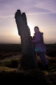
Neolithic and Bronze AgeSite Name: The Two Dogs Alternative Name: The DogsCountry: Scotland
NOTE: This site is 0.697 km away from the location you searched for.
County: Caithness Type: Standing Stone (Menhir)
Nearest Town: Dunbeath Nearest Village: Borgue
Map Ref: ND1281026389
Latitude: 58.217609N Longitude: 3.485803W
Condition:
| 5 | Perfect |
| 4 | Almost Perfect |
| 3 | Reasonable but with some damage |
| 2 | Ruined but still recognisable as an ancient site |
| 1 | Pretty much destroyed, possibly visible as crop marks |
| 0 | No data. |
| -1 | Completely destroyed |
| 5 | Superb |
| 4 | Good |
| 3 | Ordinary |
| 2 | Not Good |
| 1 | Awful |
| 0 | No data. |
| 5 | Can be driven to, probably with disabled access |
| 4 | Short walk on a footpath |
| 3 | Requiring a bit more of a walk |
| 2 | A long walk |
| 1 | In the middle of nowhere, a nightmare to find |
| 0 | No data. |
| 5 | co-ordinates taken by GPS or official recorded co-ordinates |
| 4 | co-ordinates scaled from a detailed map |
| 3 | co-ordinates scaled from a bad map |
| 2 | co-ordinates of the nearest village |
| 1 | co-ordinates of the nearest town |
| 0 | no data |
Internal Links:
External Links:
")
Said to be linked with the Upper Borgue standing stone (otherwise known as 'The Shepherd). The Two Dogs seem to be three, although one might have broken. Easily reached by parking at ND 13277 261631, walk up the track and turn left at ND 13064 26351 just past the pylon.
You may be viewing yesterday's version of this page. To see the most up to date information please register for a free account.
")
")
")
")
")
Do not use the above information on other web sites or publications without permission of the contributor.
Click here to see more info for this site
Nearby sites
Key: Red: member's photo, Blue: 3rd party photo, Yellow: other image, Green: no photo - please go there and take one, Grey: site destroyed
Download sites to:
KML (Google Earth)
GPX (GPS waypoints)
CSV (Garmin/Navman)
CSV (Excel)
To unlock full downloads you need to sign up as a Contributory Member. Otherwise downloads are limited to 50 sites.
Turn off the page maps and other distractions
Nearby sites listing. In the following links * = Image available
316m NW 324° Upper Borgue Standing Stone* Standing Stone (Menhir) (ND12632665)
787m NNW 330° Upper Borgue Broch Broch or Nuraghe (ND12432708)
2.4km NNW 329° Burg Ruadh Broch or Nuraghe (ND11602852)
3.2km SSW 199° Rinsary Broch or Nuraghe (ND11682335)
3.4km SSW 209° Rinsary Brae Ancient Village or Settlement (ND111235)
3.6km SW 228° Tulach Bad A' Choilich Broch or Nuraghe (ND10052404)
4.0km NNW 346° Bad Nan Glac Ancient Village or Settlement (ND119303)
4.0km SSW 209° Langwell House* Cairn (ND10762293)
4.2km N 11° Achorn Broch or Nuraghe (ND13693050)
4.8km SSW 212° Langwell Plantation Souterrain (Fogou, Earth House) (ND10162240)
4.8km NNE 33° Dunbeath* Broch or Nuraghe (ND155304)
4.9km NE 35° Ballachly Carved Stones* Early Christian Sculptured Stone (ND157303)
4.9km SW 217° Langwell Tulloch Broch or Nuraghe (ND09772249)
4.9km SW 217° Langwell Tulloch Hut Circle* Ancient Village or Settlement (ND09772249)
5.2km SW 226° Tulloch Turnal Broch or Nuraghe (ND09042286)
5.2km SSW 209° Borgue Langwell Hut Circle Ancient Village or Settlement (ND10162191)
5.2km NNE 27° Dunbrae Broch Broch or Nuraghe (ND15323098)
5.2km SSW 208° Borgue Langwell* Broch or Nuraghe (ND10262181)
5.4km SW 217° Cnoc Bad Fhasgaidh Ancient Village or Settlement (ND09452216)
5.4km NNE 23° Bridge of Rhemullen Broch or Nuraghe (ND15083135)
5.5km SW 220° Berriedale Chambered Cairn (ND09152223)
5.6km SW 214° Creag Buaile Dorach Ancient Village or Settlement (ND09552187)
5.8km N 11° Cairn Liath* Chambered Cairn (ND14033205)
5.8km N 11° Loedebest* Chambered Cairn (ND14003209)
5.9km N 4° Loedebest West* Chambered Cairn (ND13383229)
View more nearby sites and additional images


 We would like to know more about this location. Please feel free to add a brief description and any relevant information in your own language.
 Wir möchten mehr über diese Stätte erfahren. Bitte zögern Sie nicht, eine kurze Beschreibung und relevante Informationen in Deutsch hinzuzufügen.
 Nous aimerions en savoir encore un peu sur les lieux. S'il vous plaît n'hesitez pas à ajouter une courte description et tous les renseignements pertinents dans votre propre langue.
 Quisieramos informarnos un poco más de las lugares. No dude en añadir una breve descripción y otros datos relevantes en su propio idioma.