


<< Our Photo Pages >> St. Leonard's Well (Dunster) - Holy Well or Sacred Spring in England in Somerset
Submitted by HOLYWELL on Sunday, 24 February 2008 Page Views: 9030
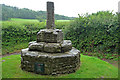
Springs and Holy WellsSite Name: St. Leonard's Well (Dunster)Country: England County: Somerset Type: Holy Well or Sacred Spring
Nearest Town: Minehead Nearest Village: Dunster
Map Ref: SS9850443867
Latitude: 51.184990N Longitude: 3.453592W
Condition:
| 5 | Perfect |
| 4 | Almost Perfect |
| 3 | Reasonable but with some damage |
| 2 | Ruined but still recognisable as an ancient site |
| 1 | Pretty much destroyed, possibly visible as crop marks |
| 0 | No data. |
| -1 | Completely destroyed |
| 5 | Superb |
| 4 | Good |
| 3 | Ordinary |
| 2 | Not Good |
| 1 | Awful |
| 0 | No data. |
| 5 | Can be driven to, probably with disabled access |
| 4 | Short walk on a footpath |
| 3 | Requiring a bit more of a walk |
| 2 | A long walk |
| 1 | In the middle of nowhere, a nightmare to find |
| 0 | No data. |
| 5 | co-ordinates taken by GPS or official recorded co-ordinates |
| 4 | co-ordinates scaled from a detailed map |
| 3 | co-ordinates scaled from a bad map |
| 2 | co-ordinates of the nearest village |
| 1 | co-ordinates of the nearest town |
| 0 | no data |
Internal Links:
External Links:
I have visited· I would like to visit
mrcrow has visited here
 (PID:37320)")
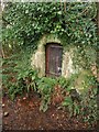
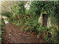
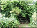
The stone structure has a triangular roof, but is much obscured so it is difficult to trace its design. A locked door prevents direct access to the well's water, but its water flows out via a pipe set in the base of the structure. This water was used for eye complaints. The well lies picturesquely by the side of the lane, overshadowed by a thorn bush, a pleasingly quiet place in comparison to the hectic nature of Dunster in Summer time.
You may be viewing yesterday's version of this page. To see the most up to date information please register for a free account.
 (PID:147883)")
Do not use the above information on other web sites or publications without permission of the contributor.
Nearby Images from Geograph Britain and Ireland:
©2010(licence)
©2010(licence)
©2018(licence)
©2010(licence)
©2010(licence)
The above images may not be of the site on this page, they are loaded from Geograph.
Please Submit an Image of this site or go out and take one for us!
Click here to see more info for this site
Nearby sites
Key: Red: member's photo, Blue: 3rd party photo, Yellow: other image, Green: no photo - please go there and take one, Grey: site destroyed
Download sites to:
KML (Google Earth)
GPX (GPS waypoints)
CSV (Garmin/Navman)
CSV (Excel)
To unlock full downloads you need to sign up as a Contributory Member. Otherwise downloads are limited to 50 sites.
Turn off the page maps and other distractions
Nearby sites listing. In the following links * = Image available
1.7km S 169° Bat's Castle* Hillfort (SS988422)
3.8km SW 228° Timberscobe Wood Hill Fort Hillfort (SS956414)
6.0km SSE 165° Druids Combe wood boundary stone Marker Stone (SS99923799)
7.1km SE 124° St Pancras Well* Holy Well or Sacred Spring (ST043398)
7.1km SSE 155° Langridge Wood Cist* Burial Chamber or Dolmen (ST01403740)
7.5km WNW 295° Bury Castle (Exmoor)* Hillfort (SS91744716)
7.7km W 261° Joaney How Cairn (SS90814279)
7.7km SSW 206° Lype Hill Barrows* Barrow Cemetery (SS949370)
7.8km W 260° Robin How* Cairn (SS90764273)
8.0km E 98° St Decumen's Well* Holy Well or Sacred Spring (ST064426)
8.3km WNW 288° Pixy Well* Holy Well or Sacred Spring (SS9066646634)
8.3km S 176° Leather Barrow Round Barrow(s) (SS98903553)
8.4km SSW 193° Cutcombe Barrow* Round Barrow(s) (SS9649635711)
8.6km E 92° Watchet Market House Museum* Museum (ST0710043439)
8.7km WNW 293° St Agnes Fountain Holy Well or Sacred Spring (SS905474)
9.2km ESE 103° Battlegore* Round Barrow(s) (ST07454162)
9.2km SSE 166° Wiveliscombe Barrow* Round Barrow(s) (ST00553486)
9.6km WSW 255° Dunkery Beacon* Barrow Cemetery (SS892416)
9.6km W 261° Sweetworthy settlement* Ancient Village or Settlement (SS890425)
9.9km SSE 161° Naked Boy stone* Standing Stone (Menhir) (ST01493447)
10.5km WSW 254° Codsend Moor Multiple Stone Rows / Avenue (SS88364110)
10.6km SSE 155° Huish Champflower Barrow* Round Barrow(s) (ST0286234167)
11.2km WSW 257° Rowbarrow Group* Barrow Cemetery (SS87544154)
11.3km SSE 162° Dun's Stone Natural Stone / Erratic / Other Natural Feature (ST018331)
12.6km WSW 256° Hoar Moor (E)* Standing Stone (Menhir) (SS86214106)
View more nearby sites and additional images


 We would like to know more about this location. Please feel free to add a brief description and any relevant information in your own language.
 Wir möchten mehr über diese Stätte erfahren. Bitte zögern Sie nicht, eine kurze Beschreibung und relevante Informationen in Deutsch hinzuzufügen.
 Nous aimerions en savoir encore un peu sur les lieux. S'il vous plaît n'hesitez pas à ajouter une courte description et tous les renseignements pertinents dans votre propre langue.
 Quisieramos informarnos un poco más de las lugares. No dude en añadir una breve descripción y otros datos relevantes en su propio idioma.