


<< Our Photo Pages >> Groes y Forwm Round Cairn - Round Cairn in Wales in Powys
Submitted by TAlanJones on Sunday, 29 May 2022 Page Views: 348
Neolithic and Bronze AgeSite Name: Groes y Forwm Round CairnCountry: Wales
NOTE: This site is 0.471 km away from the location you searched for.
County: Powys Type: Round Cairn
Nearest Town: Bala Nearest Village: Llanfyllin
Map Ref: SJ0267020670
Latitude: 52.774815N Longitude: 3.44424W
Condition:
| 5 | Perfect |
| 4 | Almost Perfect |
| 3 | Reasonable but with some damage |
| 2 | Ruined but still recognisable as an ancient site |
| 1 | Pretty much destroyed, possibly visible as crop marks |
| 0 | No data. |
| -1 | Completely destroyed |
| 5 | Superb |
| 4 | Good |
| 3 | Ordinary |
| 2 | Not Good |
| 1 | Awful |
| 0 | No data. |
| 5 | Can be driven to, probably with disabled access |
| 4 | Short walk on a footpath |
| 3 | Requiring a bit more of a walk |
| 2 | A long walk |
| 1 | In the middle of nowhere, a nightmare to find |
| 0 | No data. |
| 5 | co-ordinates taken by GPS or official recorded co-ordinates |
| 4 | co-ordinates scaled from a detailed map |
| 3 | co-ordinates scaled from a bad map |
| 2 | co-ordinates of the nearest village |
| 1 | co-ordinates of the nearest town |
| 0 | no data |
Internal Links:
External Links:
")
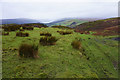
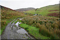
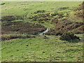
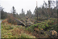
Situated along a trackway that leads to the NE from the Llyn Efyrnwy Hotel (Lake Vyrnwy Hotel) the cairn lies a few metres to the west of the trackway as it meanders through the foothills above the lake. This is a well excavated cairn with its interior hollowed out to a depth of about 0.5m creating the appearance of a crater. It has an 8.5m diameter and the outer ring is raised to about 0.4m. There are marsh grasses masking the east and northern arcs so the cairn can easily be overlooked (as I did) unless you stay alert or happen to have some form of locating device (said the Luddite).
The location affords excellent views of the Cwm (valley) below. Llyn Efyrnwy dominates but there are extensive views to the east and south.
This site is recorded as Coflein NPRN 306546, which tells us this is: "A centrally disturbed round cairn, 8.5m in diameter and 0.5m high, kerbed to the E".
You may be viewing yesterday's version of this page. To see the most up to date information please register for a free account.
")
")
")
")
Do not use the above information on other web sites or publications without permission of the contributor.
Nearby Images from Geograph Britain and Ireland:
©2016(licence)
©2007(licence)
©2016(licence)
©2007(licence)
©2016(licence)
The above images may not be of the site on this page, they are loaded from Geograph.
Please Submit an Image of this site or go out and take one for us!
Click here to see more info for this site
Nearby sites
Key: Red: member's photo, Blue: 3rd party photo, Yellow: other image, Green: no photo - please go there and take one, Grey: site destroyed
Download sites to:
KML (Google Earth)
GPX (GPS waypoints)
CSV (Garmin/Navman)
CSV (Excel)
To unlock full downloads you need to sign up as a Contributory Member. Otherwise downloads are limited to 50 sites.
Turn off the page maps and other distractions
Nearby sites listing. In the following links * = Image available
822m S 175° Round Cairn South of Groes y Forwm* Round Cairn (SJ0273019850)
2.4km NNW 342° Afon y Dolau Gwynion* Chambered Tomb (SJ01952301)
3.3km NE 41° St Illog's Well (Hirnant)* Holy Well or Sacred Spring (SJ04902313)
5.9km N 356° Pennant Melangell Cross Ancient Cross (SJ02422654)
6.4km SW 219° Mynydd Dyfnant* Stone Row / Alignment (SH9852015742)
6.6km N 357° Ffynnon Cwm Ewyn* Holy Well or Sacred Spring (SJ025273)
6.9km N 4° Craig ty-glas* Cairn (SJ03262758)
7.0km NNE 24° Craig Rhiwarth* Hillfort (SJ057270)
7.3km SW 230° The Tryfel Stones* Stone Row / Alignment (SH96991609)
8.0km NNE 22° Bedd Crynddyn* Cairn (SJ058280)
8.4km NNE 31° Glan Hafon cairn* Cairn (SJ07152776)
9.8km SSW 204° St Tydecho's Well Holy Well or Sacred Spring (SH985118)
10.0km NNE 17° Rhos Y Beddau (Circle)* Stone Circle (SJ058302)
10.0km NNE 17° Rhos y Beddau (Rows)* Multiple Stone Rows / Avenue (SJ0579530205)
10.0km NNE 25° Afon Disgynfa* Cairn (SJ07042971)
10.3km NNE 17° Cwm Rhiwiau* Stone Circle (SJ059305)
10.4km S 188° St Cadfan's Well* Holy Well or Sacred Spring (SJ010104)
10.9km S 175° The Rustica Stone Early Christian Sculptured Stone (SJ0340809775)
11.0km ENE 60° St Dogfan's (Llanrhaeadr ym Mochnant)* Ancient Cross (SJ123260)
11.1km ENE 61° Llanrhaeadr ym Mochnant (Standing Stone)* Standing Stone (Menhir) (SJ1254425902)
11.3km E 95° St Myllin's Well* Holy Well or Sacred Spring (SJ1393819533)
11.6km ENE 66° Meusydd Henge Complex* Henge (SJ134252)
11.8km ENE 68° Aber Rhaeadr* Standing Stone (Menhir) (SJ1369624820)
11.9km NNE 18° Moel Sych* Cairn (SJ066319)
12.1km N 1° Yr Aran* Barrow Cemetery (SJ03053279)
View more nearby sites and additional images


 We would like to know more about this location. Please feel free to add a brief description and any relevant information in your own language.
 Wir möchten mehr über diese Stätte erfahren. Bitte zögern Sie nicht, eine kurze Beschreibung und relevante Informationen in Deutsch hinzuzufügen.
 Nous aimerions en savoir encore un peu sur les lieux. S'il vous plaît n'hesitez pas à ajouter une courte description et tous les renseignements pertinents dans votre propre langue.
 Quisieramos informarnos un poco más de las lugares. No dude en añadir una breve descripción y otros datos relevantes en su propio idioma.