


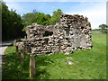
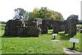
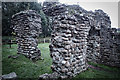
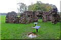
<< Our Photo Pages >> Roman Bath House, Ravenglass, Cumbria - Ancient Village or Settlement in England in Cumbria
Submitted by cactus_chris on Wednesday, 09 November 2022 Page Views: 312
Roman, Greek and ClassicalSite Name: Roman Bath House, Ravenglass, CumbriaCountry: England
NOTE: This site is 0.591 km away from the location you searched for.
County: Cumbria Type: Ancient Village or Settlement
Nearest Town: Ravenglass
Map Ref: SD0882795927
Latitude: 54.350699N Longitude: 3.404226W
Condition:
| 5 | Perfect |
| 4 | Almost Perfect |
| 3 | Reasonable but with some damage |
| 2 | Ruined but still recognisable as an ancient site |
| 1 | Pretty much destroyed, possibly visible as crop marks |
| 0 | No data. |
| -1 | Completely destroyed |
| 5 | Superb |
| 4 | Good |
| 3 | Ordinary |
| 2 | Not Good |
| 1 | Awful |
| 0 | No data. |
| 5 | Can be driven to, probably with disabled access |
| 4 | Short walk on a footpath |
| 3 | Requiring a bit more of a walk |
| 2 | A long walk |
| 1 | In the middle of nowhere, a nightmare to find |
| 0 | No data. |
| 5 | co-ordinates taken by GPS or official recorded co-ordinates |
| 4 | co-ordinates scaled from a detailed map |
| 3 | co-ordinates scaled from a bad map |
| 2 | co-ordinates of the nearest village |
| 1 | co-ordinates of the nearest town |
| 0 | no data |
Internal Links:
External Links:
I have visited· I would like to visit
cactus_chris visited on 29th Jul 2019 - their rating: Cond: 4 Amb: 5 Access: 3
")
You may be viewing yesterday's version of this page. To see the most up to date information please register for a free account.
Do not use the above information on other web sites or publications without permission of the contributor.
Nearby Images from Geograph Britain and Ireland:
©2016(licence)
©2016(licence)

©2018(licence)
©2018(licence)
©2017(licence)
The above images may not be of the site on this page, they are loaded from Geograph.
Please Submit an Image of this site or go out and take one for us!
Click here to see more info for this site
Nearby sites
Key: Red: member's photo, Blue: 3rd party photo, Yellow: other image, Green: no photo - please go there and take one, Grey: site destroyed
Download sites to:
KML (Google Earth)
GPX (GPS waypoints)
CSV (Garmin/Navman)
CSV (Excel)
To unlock full downloads you need to sign up as a Contributory Member. Otherwise downloads are limited to 50 sites.
Turn off the page maps and other distractions
Nearby sites listing. In the following links * = Image available
1.2km SW 221° Glannoventa* Ancient Village or Settlement (SD0895)
1.5km ESE 123° Waberthwaite Cross* Ancient Cross (SD10039510)
1.7km ENE 67° St Michaels Church, Muncaster Castle* Ancient Cross (SD10399656)
3.0km WNW 285° Drigg sand dunes* Ancient Mine, Quarry or other Industry (SD059968)
4.4km E 91° Barnscar Settlement, Birkby Fell* Ancient Village or Settlement (SD132958)
4.5km N 3° Irton Cross* Ancient Cross (NY0916000455)
5.0km ESE 113° Whitrow Beck* Stone Circle (SD13429387)
6.9km ENE 78° Devoke Water and Water Crag* Ring Cairn (SD1563397273)
7.1km NNE 31° Irton Pike Ring Cairn Ring Cairn (NY1261601907)
7.8km NNW 347° Gosforth Cross* Ancient Cross (NY07230357)
8.0km SE 126° Buckbarrow Crag, Hare Raise, Burn Moor and Whitfell Cairn (SD152911)
8.1km NNW 347° Gosforth Holy Well* Holy Well or Sacred Spring (NY07190383)
8.1km SE 146° Bootle Fell Cairns* Cairn (SD1331989116)
8.2km SE 146° Bootle Fell Round Cairn 4* Round Cairn (SD1333389018)
8.3km NNW 337° Gretigate A Stone Circle (NY057036)
8.3km NNW 338° Gretigate B Stone Circle (NY058037)
8.3km NNW 338° Gretigate C Stone Circle (NY058037)
8.3km SE 144° Bootle Fell Round Cairn 1* Round Cairn (SD1354789043)
8.4km SSE 146° Bootle Fell Round Cairn 2/3* Round Cairn (SD1336388790)
8.5km NW 319° Grey Croft* Stone Circle (NY03340238)
9.3km E 88° Brown Rigg Round Cairn* Round Cairn (SD1812396059)
9.6km E 87° Wormkragg Stiner Stone Row / Alignment (SD184963)
10.3km ENE 64° St Catherine's Well (Boot)* Holy Well or Sacred Spring (NY18150030)
10.5km SSE 166° Hall Foss Stone Circle (SD112857)
10.6km NE 51° White Moss SW* Stone Circle (NY17250239)
View more nearby sites and additional images


 We would like to know more about this location. Please feel free to add a brief description and any relevant information in your own language.
 Wir möchten mehr über diese Stätte erfahren. Bitte zögern Sie nicht, eine kurze Beschreibung und relevante Informationen in Deutsch hinzuzufügen.
 Nous aimerions en savoir encore un peu sur les lieux. S'il vous plaît n'hesitez pas à ajouter une courte description et tous les renseignements pertinents dans votre propre langue.
 Quisieramos informarnos un poco más de las lugares. No dude en añadir una breve descripción y otros datos relevantes en su propio idioma.