

<< Our Photo Pages >> Huntsham Castle - Misc. Earthwork in England in Devon
Submitted by SolarMegalith on Monday, 09 May 2011 Page Views: 7528
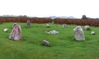
Multi-periodSite Name: Huntsham CastleCountry: England County: Devon Type: Misc. Earthwork
Nearest Village: Huntsham
Map Ref: SS99111784
Latitude: 50.951133N Longitude: 3.437655W
Condition:
| 5 | Perfect |
| 4 | Almost Perfect |
| 3 | Reasonable but with some damage |
| 2 | Ruined but still recognisable as an ancient site |
| 1 | Pretty much destroyed, possibly visible as crop marks |
| 0 | No data. |
| -1 | Completely destroyed |
| 5 | Superb |
| 4 | Good |
| 3 | Ordinary |
| 2 | Not Good |
| 1 | Awful |
| 0 | No data. |
| 5 | Can be driven to, probably with disabled access |
| 4 | Short walk on a footpath |
| 3 | Requiring a bit more of a walk |
| 2 | A long walk |
| 1 | In the middle of nowhere, a nightmare to find |
| 0 | No data. |
| 5 | co-ordinates taken by GPS or official recorded co-ordinates |
| 4 | co-ordinates scaled from a detailed map |
| 3 | co-ordinates scaled from a bad map |
| 2 | co-ordinates of the nearest village |
| 1 | co-ordinates of the nearest town |
| 0 | no data |
Internal Links:
External Links:
")
Remains of a non-defensive Iron Age enclosure.
Read More at PastScape.
You may be viewing yesterday's version of this page. To see the most up to date information please register for a free account.
")
")
")
")
")
")
")
Do not use the above information on other web sites or publications without permission of the contributor.
Click here to see more info for this site
Nearby sites
Key: Red: member's photo, Blue: 3rd party photo, Yellow: other image, Green: no photo - please go there and take one, Grey: site destroyed
Download sites to:
KML (Google Earth)
GPX (GPS waypoints)
CSV (Garmin/Navman)
CSV (Excel)
To unlock full downloads you need to sign up as a Contributory Member. Otherwise downloads are limited to 50 sites.
Turn off the page maps and other distractions
Nearby sites listing. In the following links * = Image available
3.9km S 186° Craze Lowman Mound* Round Barrow(s) (SS98611399)
5.4km W 273° Castle Close* Misc. Earthwork (SS937182)
6.7km SSW 207° Cranmore Castle Hillfort (SS959119)
9.3km NE 44° Castles Camp Hillfort (ST057244)
13.2km NW 321° Oldberry Castle Hillfort (SS90932820)
14.0km WSW 258° Witheridge Moor Barrows* Barrow Cemetery (SS853152)
14.1km W 271° Holy Trinity Well (Rackenford)* Holy Well or Sacred Spring (SS85001825)
14.8km SSW 211° Cadbury Castle (Devon)* Hillfort (SS913053)
14.8km NE 44° Kings Castle Hillfort (ST097282)
15.5km N 9° Dun's Stone Natural Stone / Erratic / Other Natural Feature (ST018331)
15.6km W 266° Berry Castle (Devon)* Hillfort (SS835171)
15.7km NW 317° Mounsey Castle Hillfort (SS88562955)
16.1km NW 317° Brewer's Castle Hillfort (SS88332977)
16.1km WNW 283° Knowstone Inner Moor Round Barrow(s) (SS8346021869)
16.7km NNE 12° Huish Champflower Barrow* Round Barrow(s) (ST0286234167)
16.8km N 7° Naked Boy stone* Standing Stone (Menhir) (ST01493447)
16.9km S 179° Holy Well (Broadclyst)* Holy Well or Sacred Spring (SS9914700962)
17.0km WNW 282° Beaples Hill* Standing Stone (Menhir) (SS8248621693)
17.1km N 4° Wiveliscombe Barrow* Round Barrow(s) (ST00553486)
17.7km N 358° Leather Barrow Round Barrow(s) (SS98903553)
17.7km NW 309° West Anstey Barrows* Barrow Cemetery (SS85452918)
17.8km NNE 25° Elworthy Barrows hillfort* Hillfort (ST070338)
17.8km S 184° Dolbury Hillfort* Hillfort (SS974001)
18.1km N 351° Cutcombe Barrow* Round Barrow(s) (SS9649635711)
18.1km SW 215° Raddon Hill* Causewayed Enclosure (SS885031)
View more nearby sites and additional images


 We would like to know more about this location. Please feel free to add a brief description and any relevant information in your own language.
 Wir möchten mehr über diese Stätte erfahren. Bitte zögern Sie nicht, eine kurze Beschreibung und relevante Informationen in Deutsch hinzuzufügen.
 Nous aimerions en savoir encore un peu sur les lieux. S'il vous plaît n'hesitez pas à ajouter une courte description et tous les renseignements pertinents dans votre propre langue.
 Quisieramos informarnos un poco más de las lugares. No dude en añadir una breve descripción y otros datos relevantes en su propio idioma.