


<< Our Photo Pages >> Careg-Y-Caws - Cairn in Wales in Denbighshire
Submitted by coldrum on Tuesday, 12 October 2010 Page Views: 2907
Neolithic and Bronze AgeSite Name: Careg-Y-CawsCountry: Wales
NOTE: This site is 0.484 km away from the location you searched for.
County: Denbighshire Type: Cairn
Map Ref: SJ09133650
Latitude: 52.918204N Longitude: 3.352925W
Condition:
| 5 | Perfect |
| 4 | Almost Perfect |
| 3 | Reasonable but with some damage |
| 2 | Ruined but still recognisable as an ancient site |
| 1 | Pretty much destroyed, possibly visible as crop marks |
| 0 | No data. |
| -1 | Completely destroyed |
| 5 | Superb |
| 4 | Good |
| 3 | Ordinary |
| 2 | Not Good |
| 1 | Awful |
| 0 | No data. |
| 5 | Can be driven to, probably with disabled access |
| 4 | Short walk on a footpath |
| 3 | Requiring a bit more of a walk |
| 2 | A long walk |
| 1 | In the middle of nowhere, a nightmare to find |
| 0 | No data. |
| 5 | co-ordinates taken by GPS or official recorded co-ordinates |
| 4 | co-ordinates scaled from a detailed map |
| 3 | co-ordinates scaled from a bad map |
| 2 | co-ordinates of the nearest village |
| 1 | co-ordinates of the nearest town |
| 0 | no data |
Be the first person to rate this site - see the 'Contribute!' box in the right hand menu.
Internal Links:
External Links:
I have visited· I would like to visit
Andy B has visited here
")
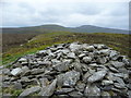
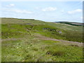
"Probable oval funerary cairn on saddle. Mostly covered in grass and bilberry and surrounded by heather. Only distinct from natural hillocks in this area due to the lack of exposed bedrock and the presence of small stone rubble throughout. Disturbed on W and NE where stones have been removed and placed into a modern cairn which lies on the crest of the original cairn. The original cairn appears to have been created by piling rubble onto a natural hillock. Original cairn measures 24.0m E/W by 21.5m and is up to 3.0m high (on W), while the modern cairn is 5.0m in diameter and 1.3m high."
Source: Coflein
You may be viewing yesterday's version of this page. To see the most up to date information please register for a free account.
Do not use the above information on other web sites or publications without permission of the contributor.
Nearby Images from Geograph Britain and Ireland:
©2010(licence)
©2006(licence)
©2006(licence)
©2023(licence)
©2019(licence)
The above images may not be of the site on this page, they are loaded from Geograph.
Please Submit an Image of this site or go out and take one for us!
Click here to see more info for this site
Nearby sites
Key: Red: member's photo, Blue: 3rd party photo, Yellow: other image, Green: no photo - please go there and take one, Grey: site destroyed
Download sites to:
KML (Google Earth)
GPX (GPS waypoints)
CSV (Garmin/Navman)
CSV (Excel)
To unlock full downloads you need to sign up as a Contributory Member. Otherwise downloads are limited to 50 sites.
Turn off the page maps and other distractions
Nearby sites listing. In the following links * = Image available
663m WNW 290° Pen Bwlch Llandrillo Cairn (SJ08513674)
2.3km SW 217° Bwrdd Arthur* Cairn (SJ077347)
2.6km NNE 14° Nant Croes Y Wernen* Stone Circle (SJ09813906)
3.1km SSW 201° Bwlch Maen Gwynedd* Cairn (SJ07953364)
3.3km W 263° Cerrig Bwlch Y Fedw* Stone Circle (SJ05873615)
3.4km SSW 202° Berwyn mountains Marker stones* Marker Stone (SJ078334)
3.6km W 280° Moel Ty Uchaf* Stone Circle (SJ05613717)
4.3km SSW 206° Cadair Berwyn* Cairn (SJ072327)
4.3km S 183° Cwm Maen Gwynedd Stone Row II Stone Row / Alignment (SJ0885332238)
4.4km S 183° Cwm Maen Gwynedd Stone Row I Stone Row / Alignment (SJ0881132142)
4.5km SSW 205° Cader Berwyn Cairn 2* Cairn (SJ07173245)
5.2km SSW 208° Moel Sych* Cairn (SJ066319)
5.3km NW 304° Tyn y Coed* Chambered Cairn (SJ0476839603)
5.4km SW 232° Pennant* Round Cairn (SJ04823331)
5.4km SW 235° Cwm Tywyll* Ring Cairn (SJ04683346)
5.8km WSW 238° Cefn Penagored Ridge Cairns* Cairn (SJ041335)
5.9km SW 232° Nant Esgeiriau* Round Cairn (SJ044329)
6.0km WSW 240° Cefn Penagored Cairn and Ring Cairn* Cairn (SJ039336)
6.1km WSW 248° Penagored Standing Stone* Standing Stone (Menhir) (SJ034343)
6.5km ESE 111° Cerrig Gwynion (Wrexham)* Hillfort (SJ152341)
6.6km E 92° Carnedd Rhys Goch* Cairn (SJ15763613)
6.6km WSW 240° Rhyd y Gethin Standing Stone (Menhir) (SJ03303330)
6.7km WNW 289° Tyfos* Stone Circle (SJ02843876)
6.8km SSW 207° Cwm Rhiwiau* Stone Circle (SJ059305)
6.9km NNW 346° Corwen Gorsedd Circle Modern Stone Circle etc (SJ0763443219)
View more nearby sites and additional images


 We would like to know more about this location. Please feel free to add a brief description and any relevant information in your own language.
 Wir möchten mehr über diese Stätte erfahren. Bitte zögern Sie nicht, eine kurze Beschreibung und relevante Informationen in Deutsch hinzuzufügen.
 Nous aimerions en savoir encore un peu sur les lieux. S'il vous plaît n'hesitez pas à ajouter une courte description et tous les renseignements pertinents dans votre propre langue.
 Quisieramos informarnos un poco más de las lugares. No dude en añadir una breve descripción y otros datos relevantes en su propio idioma.