

<< Text Pages >> Newhouse Standing Stone - Standing Stone (Menhir) in Scotland in Midlothian
Submitted by Anne T on Monday, 22 October 2018 Page Views: 1197
Neolithic and Bronze AgeSite Name: Newhouse Standing StoneCountry: Scotland
NOTE: This site is 1.635 km away from the location you searched for.
County: Midlothian Type: Standing Stone (Menhir)
Nearest Town: Edinburgh Nearest Village: Balerno
Map Ref: NT15296838
Latitude: 55.901054N Longitude: 3.356354W
Condition:
| 5 | Perfect |
| 4 | Almost Perfect |
| 3 | Reasonable but with some damage |
| 2 | Ruined but still recognisable as an ancient site |
| 1 | Pretty much destroyed, possibly visible as crop marks |
| 0 | No data. |
| -1 | Completely destroyed |
| 5 | Superb |
| 4 | Good |
| 3 | Ordinary |
| 2 | Not Good |
| 1 | Awful |
| 0 | No data. |
| 5 | Can be driven to, probably with disabled access |
| 4 | Short walk on a footpath |
| 3 | Requiring a bit more of a walk |
| 2 | A long walk |
| 1 | In the middle of nowhere, a nightmare to find |
| 0 | No data. |
| 5 | co-ordinates taken by GPS or official recorded co-ordinates |
| 4 | co-ordinates scaled from a detailed map |
| 3 | co-ordinates scaled from a bad map |
| 2 | co-ordinates of the nearest village |
| 1 | co-ordinates of the nearest town |
| 0 | no data |
Be the first person to rate this site - see the 'Contribute!' box in the right hand menu.
Internal Links:
External Links:
Standing Stone (Menhir) in Midlothian
This 1.6m tall standing stone is recorded as Canmore ID 50277, which gives basic details.
This stone is also featured on the Ancient Stones: A Guide to Standing Stones and Stone Circles in the South of Scotland - see their entry for Standing Stone, Newhouse, Ratho, which includes a description, directions for finding the stone with nearby parking, folklore and fieldnotes.
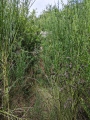
The Ancient Stones tells us this stone is well concealed amongst tall vegetation (in a September visit, this was 6ft high in places and comprised brambles, nettles and bracken!), adding: "This well concealed standing stone stands to 1.75m high and measures 0.90 x 0.65m on plan. In section the stone has a 'diamond' shape, with a large section missing at the base on the north side. The stone is well weathered and marked. Not shown on O.S. Landranger or Explorer Series maps."
Note: Have you visited this site? Do you have any photographs or information to add?
You may be viewing yesterday's version of this page. To see the most up to date information please register for a free account.
Do not use the above information on other web sites or publications without permission of the contributor.
Nearby Images from Geograph Britain and Ireland:
©2005(licence)
©2014(licence)
©2010(licence)
©2022(licence)
©2017(licence)
The above images may not be of the site on this page, they are loaded from Geograph.
Please Submit an Image of this site or go out and take one for us!
Click here to see more info for this site
Nearby sites
Key: Red: member's photo, Blue: 3rd party photo, Yellow: other image, Green: no photo - please go there and take one, Grey: site destroyed
Download sites to:
KML (Google Earth)
GPX (GPS waypoints)
CSV (Garmin/Navman)
CSV (Excel)
To unlock full downloads you need to sign up as a Contributory Member. Otherwise downloads are limited to 50 sites.
Turn off the page maps and other distractions
Nearby sites listing. In the following links * = Image available
2.3km SW 229° Dalmahoy Hill Hillfort (NT135669)
2.7km WNW 297° Tormain Hill* Rock Art (NT12906967)
2.9km WNW 297° Witches' Stone (Ratho)* Rock Art (NT12736973)
3.0km SW 229° Kaimes Standing Stones (NT130665)
3.1km E 101° St Mungo's Well (Edinburgh)* Holy Well or Sacred Spring (NT18346773)
3.4km NW 320° Witchis Stane* Standing Stone (Menhir) (NT13177104)
3.6km N 2° Gogar Stone* Standing Stone (Menhir) (NT15487199)
4.1km WSW 248° Kirknewton stone Sculptured Stone (NT11426693)
5.0km NNW 327° Lochend menhir* Standing Stone (Menhir) (NT12667263)
5.1km NW 324° Huly Hill Cairn* Round Cairn (NT1234272610)
5.1km NW 324° Huly Hill Standing Stones* Standing Stones (NT1234272610)
6.0km NE 45° Physic Well (Corstorphine)* Holy Well or Sacred Spring (NT19597252)
6.0km N 355° Cat Stane (Kirkliston)* Standing Stone (Menhir) (NT1489374373)
6.0km NE 44° Lady Well* Holy Well or Sacred Spring (NT196726)
6.4km NNW 345° Carlowrie (Kirkliston) Rock Art (NT138746)
6.7km NNE 18° Cammo Stone* Standing Stone (Menhir) (NT1747774681)
7.7km ENE 76° Craiglockart Hill Vitrified Fort Hillfort (NT22827006)
8.2km SE 141° Carnethy Hill cairn* Cairn (NT20386192)
8.7km ESE 103° Caerketton Hill* Cairn (NT23706621)
8.8km ESE 118° Castle Knowe (Glencorse)* Ancient Village or Settlement (NT22996404)
8.8km ESE 120° Castle Law* Hillfort (NT2290063870)
8.9km E 89° Caiy Stane* Standing Stone (Menhir) (NT2424368357)
9.1km E 86° 1, West Camus Road* Modern Stone Circle etc (NT2441068763)
9.1km E 90° Fairmiliehead (Edinburgh) Cairn (NT24466828)
9.2km NE 54° Succoth Place Double Cist Burial Cist (NT22897362)
View more nearby sites and additional images


 We would like to know more about this location. Please feel free to add a brief description and any relevant information in your own language.
 Wir möchten mehr über diese Stätte erfahren. Bitte zögern Sie nicht, eine kurze Beschreibung und relevante Informationen in Deutsch hinzuzufügen.
 Nous aimerions en savoir encore un peu sur les lieux. S'il vous plaît n'hesitez pas à ajouter une courte description et tous les renseignements pertinents dans votre propre langue.
 Quisieramos informarnos un poco más de las lugares. No dude en añadir una breve descripción y otros datos relevantes en su propio idioma.