 with our Megalithic Portal iPhone app")


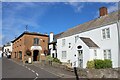
<< Other Photo Pages >> Watchet Market House Museum - Museum in England in Somerset
Submitted by coldrum on Tuesday, 30 June 2009 Page Views: 4084
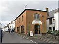
MuseumsSite Name: Watchet Market House MuseumCountry: England
NOTE: This site is 0.56 km away from the location you searched for.
County: Somerset Type: Museum
Nearest Village: Watchet
Map Ref: ST0710043439
Latitude: 51.182606N Longitude: 3.330526W
Condition:
| 5 | Perfect |
| 4 | Almost Perfect |
| 3 | Reasonable but with some damage |
| 2 | Ruined but still recognisable as an ancient site |
| 1 | Pretty much destroyed, possibly visible as crop marks |
| 0 | No data. |
| -1 | Completely destroyed |
| 5 | Superb |
| 4 | Good |
| 3 | Ordinary |
| 2 | Not Good |
| 1 | Awful |
| 0 | No data. |
| 5 | Can be driven to, probably with disabled access |
| 4 | Short walk on a footpath |
| 3 | Requiring a bit more of a walk |
| 2 | A long walk |
| 1 | In the middle of nowhere, a nightmare to find |
| 0 | No data. |
| 5 | co-ordinates taken by GPS or official recorded co-ordinates |
| 4 | co-ordinates scaled from a detailed map |
| 3 | co-ordinates scaled from a bad map |
| 2 | co-ordinates of the nearest village |
| 1 | co-ordinates of the nearest town |
| 0 | no data |
Internal Links:
External Links:
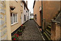
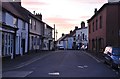
Museum in Somerset
The museum houses many documents and artefacts charting Watchet's history through the ages. The museum also develops studies on more detailed themes for those with a deeper interest in history. There is a regular programme of speakers giving talks on specialist subjects.
Admission to the museum is free, although donations are always welcome. For more information please call the Curator, Roger Wedlake, on 01984 631209.
Opening Times: Easter to 31st October : 10.30am - 4.30pm daily. Otherwise by arrangement.
Website: Watchet Museum.
Also just outside Watchet are the earthwork remains of a fortified Saxon site called Daws Castle.
You may be viewing yesterday's version of this page. To see the most up to date information please register for a free account.
Do not use the above information on other web sites or publications without permission of the contributor.
davidmorgan has found this location on Google Street View:
Nearby Images from Geograph Britain and Ireland:
©2016(licence)
©2014(licence)
©2013(licence)
©2015(licence)
©2023(licence)
The above images may not be of the site on this page, they are loaded from Geograph.
Please Submit an Image of this site or go out and take one for us!
Click here to see more info for this site
Nearby sites
Key: Red: member's photo, Blue: 3rd party photo, Yellow: other image, Green: no photo - please go there and take one, Grey: site destroyed
Download sites to:
KML (Google Earth)
GPX (GPS waypoints)
CSV (Garmin/Navman)
CSV (Excel)
To unlock full downloads you need to sign up as a Contributory Member. Otherwise downloads are limited to 50 sites.
Turn off the page maps and other distractions
Nearby sites listing. In the following links * = Image available
1.1km SW 219° St Decumen's Well* Holy Well or Sacred Spring (ST064426)
1.9km SSE 168° Battlegore* Round Barrow(s) (ST07454162)
4.6km SW 216° St Pancras Well* Holy Well or Sacred Spring (ST043398)
5.8km SSE 147° Curdon Camp Hillfort (ST102385)
5.8km ESE 114° Beacon Hill Platform Cairn* Barrow Cemetery (ST12434101)
6.2km SE 130° Trendle Ring* Ancient Village or Settlement (ST118394)
6.9km SE 125° Thorncombe Barrow* Cairn (ST12733942)
7.4km SE 124° Thorncombe Hill Cairns* Barrow Cemetery (ST13183914)
7.6km ESE 109° Holford Standing Stone* Standing Stone (Menhir) (ST142408)
8.0km ESE 124° Halsway Tumuli* Barrow Cemetery (ST137389)
8.3km SW 222° Langridge Wood Cist* Burial Chamber or Dolmen (ST01403740)
8.4km W 260° Bat's Castle* Hillfort (SS988422)
8.6km W 272° St. Leonard's Well (Dunster)* Holy Well or Sacred Spring (SS9850443867)
8.9km SE 126° Hurley Beacon Tumulus* Cairn (ST14223808)
9.0km SW 232° Druids Combe wood boundary stone Marker Stone (SS99923799)
9.2km SE 124° Black Hill Tumuli* Barrow Cemetery (ST14653819)
9.6km S 180° Elworthy Barrows hillfort* Hillfort (ST070338)
9.7km ESE 122° Wilmots Pool Cairn* Cairn (ST15303813)
9.8km ESE 114° Dowsborough Castle* Hillfort (ST160392)
10.1km SE 129° Fire Beacon Cairn* Cairn (ST14913697)
10.2km SSW 203° Huish Champflower Barrow* Round Barrow(s) (ST0286234167)
10.4km SE 126° West Hill Platform Cairn* Cairn (ST15423717)
10.5km ESE 119° Dead Woman's Ditch* Misc. Earthwork (ST162381)
10.6km SSW 211° Naked Boy stone* Standing Stone (Menhir) (ST01493447)
10.8km SW 216° Wiveliscombe Barrow* Round Barrow(s) (ST00553486)
View more nearby sites and additional images


 We would like to know more about this location. Please feel free to add a brief description and any relevant information in your own language.
 Wir möchten mehr über diese Stätte erfahren. Bitte zögern Sie nicht, eine kurze Beschreibung und relevante Informationen in Deutsch hinzuzufügen.
 Nous aimerions en savoir encore un peu sur les lieux. S'il vous plaît n'hesitez pas à ajouter une courte description et tous les renseignements pertinents dans votre propre langue.
 Quisieramos informarnos un poco más de las lugares. No dude en añadir una breve descripción y otros datos relevantes en su propio idioma.