


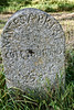
<< Our Photo Pages >> Menhir de Cornec - Standing Stone (Menhir) in France in Bretagne:Côtes-D'Armor (22)
Submitted by JohnGinny on Saturday, 11 August 2007 Page Views: 3783
Neolithic and Bronze AgeSite Name: Menhir de CornecCountry: France
NOTE: This site is 2.868 km away from the location you searched for.
Département: Bretagne:Côtes-D'Armor (22) Type: Standing Stone (Menhir)
Nearest Town: Rostrenen Nearest Village: Mellionnec
Latitude: 48.188970N Longitude: 3.26978W
Condition:
| 5 | Perfect |
| 4 | Almost Perfect |
| 3 | Reasonable but with some damage |
| 2 | Ruined but still recognisable as an ancient site |
| 1 | Pretty much destroyed, possibly visible as crop marks |
| 0 | No data. |
| -1 | Completely destroyed |
| 5 | Superb |
| 4 | Good |
| 3 | Ordinary |
| 2 | Not Good |
| 1 | Awful |
| 0 | No data. |
| 5 | Can be driven to, probably with disabled access |
| 4 | Short walk on a footpath |
| 3 | Requiring a bit more of a walk |
| 2 | A long walk |
| 1 | In the middle of nowhere, a nightmare to find |
| 0 | No data. |
| 5 | co-ordinates taken by GPS or official recorded co-ordinates |
| 4 | co-ordinates scaled from a detailed map |
| 3 | co-ordinates scaled from a bad map |
| 2 | co-ordinates of the nearest village |
| 1 | co-ordinates of the nearest town |
| 0 | no data |
Internal Links:
External Links:
I have visited· I would like to visit
johnstone visited on 16th Jun 2023 - their rating: Cond: 3 Amb: 2 Access: 4
JohnGinny have visited here
")
Base Mérimée (Patrimonial Inventory)
See also: T4T35
Reference:
Loïc Langouët, Les Mégalithes de l’Arrondissement de Guingamp, 2006, p.50-51
You may be viewing yesterday's version of this page. To see the most up to date information please register for a free account.
")
")
")
Do not use the above information on other web sites or publications without permission of the contributor.
Nearby Images from Flickr
The above images may not be of the site on this page, but were taken nearby. They are loaded from Flickr so please click on them for image credits.
Click here to see more info for this site
Nearby sites
Click here to view sites on an interactive map of the areaKey: Red: member's photo, Blue: 3rd party photo, Yellow: other image, Green: no photo - please go there and take one, Grey: site destroyed
Download sites to:
KML (Google Earth)
GPX (GPS waypoints)
CSV (Garmin/Navman)
CSV (Excel)
To unlock full downloads you need to sign up as a Contributory Member. Otherwise downloads are limited to 50 sites.
Turn off the page maps and other distractions
Nearby sites listing. In the following links * = Image available
1.0km NE 53° Menhir d'Hacadour* Standing Stone (Menhir)
5.1km NE 39° Menhirs de Saint Jean* Standing Stones
5.3km N 2° Menhir de Kerallain* Standing Stone (Menhir)
5.6km NNW 348° Menhir de Kerauffret* Standing Stone (Menhir)
5.6km SE 133° Quenouille Du Diable* Standing Stone (Menhir)
5.9km S 173° Menhir de Kergoët Standing Stone (Menhir)
6.6km WNW 283° Menhir du Château de Coat-Couravel* Standing Stone (Menhir)
7.0km ENE 62° Allée Couverte de Kérivalan* Passage Grave
7.3km SE 141° Dolmen de Villeneuve Burial Chamber or Dolmen
7.6km ENE 67° Plélauff stèle* Standing Stone (Menhir)
7.8km ENE 71° Bochacoat allée couverte* Passage Grave
9.4km WNW 294° Menhir de Glomel* Standing Stone (Menhir)
10.1km SW 233° Dolmen de Guidfosse* Burial Chamber or Dolmen
11.0km ENE 71° Liscuis 3 allée couverte* Passage Grave
11.0km ENE 71° Liscuis 2 allée couverte* Passage Grave
11.1km ENE 71° Liscuis 1 allée couverte* Passage Grave
11.3km SSE 164° Allée Couverte du Lannic* Passage Grave
11.5km ENE 69° Menhirs de Canac'h Léron* Standing Stones
11.6km ESE 113° Allée Couverte du Grand Boduic Passage Grave
12.2km SSE 166° Fontaine de Krenenan* Holy Well or Sacred Spring
12.9km ESE 107° Allée Couverte de Toulhardi Passage Grave
13.2km ENE 62° St Gildas Well (Laniscat)* Holy Well or Sacred Spring
13.3km ENE 61° Menhir de la Chapelle Saint-Gildas* Standing Stone (Menhir)
13.8km ESE 108° Allée Couverte de Park-er-Bé Passage Grave
14.0km E 101° Menhir du Breuil-du-Chêne 4 Standing Stone (Menhir)
View more nearby sites and additional images


 We would like to know more about this location. Please feel free to add a brief description and any relevant information in your own language.
 Wir möchten mehr über diese Stätte erfahren. Bitte zögern Sie nicht, eine kurze Beschreibung und relevante Informationen in Deutsch hinzuzufügen.
 Nous aimerions en savoir encore un peu sur les lieux. S'il vous plaît n'hesitez pas à ajouter une courte description et tous les renseignements pertinents dans votre propre langue.
 Quisieramos informarnos un poco más de las lugares. No dude en añadir una breve descripción y otros datos relevantes en su propio idioma.