


<< Our Photo Pages >> Fontaine du Coq - Holy Well or Sacred Spring in France in Bretagne:Côtes-D'Armor (22)
Submitted by ogham on Wednesday, 22 May 2013 Page Views: 2463
Springs and Holy WellsSite Name: Fontaine du CoqCountry: France
NOTE: This site is 4.216 km away from the location you searched for.
Département: Bretagne:Côtes-D'Armor (22) Type: Holy Well or Sacred Spring
Nearest Town: Guingamp Nearest Village: Bulat-Pestivien
Latitude: 48.428396N Longitude: 3.333887W
Condition:
| 5 | Perfect |
| 4 | Almost Perfect |
| 3 | Reasonable but with some damage |
| 2 | Ruined but still recognisable as an ancient site |
| 1 | Pretty much destroyed, possibly visible as crop marks |
| 0 | No data. |
| -1 | Completely destroyed |
| 5 | Superb |
| 4 | Good |
| 3 | Ordinary |
| 2 | Not Good |
| 1 | Awful |
| 0 | No data. |
| 5 | Can be driven to, probably with disabled access |
| 4 | Short walk on a footpath |
| 3 | Requiring a bit more of a walk |
| 2 | A long walk |
| 1 | In the middle of nowhere, a nightmare to find |
| 0 | No data. |
| 5 | co-ordinates taken by GPS or official recorded co-ordinates |
| 4 | co-ordinates scaled from a detailed map |
| 3 | co-ordinates scaled from a bad map |
| 2 | co-ordinates of the nearest village |
| 1 | co-ordinates of the nearest town |
| 0 | no data |
Internal Links:
External Links:
I have visited· I would like to visit
Chrus visited on 22nd Aug 2017 - their rating: Cond: 4 Amb: 5 Access: 5
Ogham have visited here
")
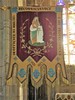
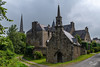
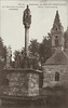
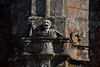
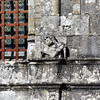
Located along the D50 road heading towards Callac, near the fountain of seven saints, the fountain was built in 1550.
It has been registered as a historical monument since 1913. It is believed that it is so called because a cock was probably sat on the top of the original wooden cross.
It is composed of twin fountains, built in the style of the renaissance, feeding three shallow basins used for ablutions.
Against the wall is a stone bench which allowed pilgrims to rest.
You may be viewing yesterday's version of this page. To see the most up to date information please register for a free account.
")
")
")
Do not use the above information on other web sites or publications without permission of the contributor.
Nearby Images from Flickr

The above images may not be of the site on this page, but were taken nearby. They are loaded from Flickr so please click on them for image credits.
Click here to see more info for this site
Nearby sites
Click here to view sites on an interactive map of the areaKey: Red: member's photo, Blue: 3rd party photo, Yellow: other image, Green: no photo - please go there and take one, Grey: site destroyed
Download sites to:
KML (Google Earth)
GPX (GPS waypoints)
CSV (Garmin/Navman)
CSV (Excel)
To unlock full downloads you need to sign up as a Contributory Member. Otherwise downloads are limited to 50 sites.
Turn off the page maps and other distractions
Nearby sites listing. In the following links * = Image available
59m WNW 296° Fontaine des Sept Saints* Holy Well or Sacred Spring
4.5km S 186° Menhir de Kernaëret* Standing Stone (Menhir)
4.6km SE 142° Pierre de Coat-ar-Men-Sul Natural Stone / Erratic / Other Natural Feature
5.8km E 93° Alignement de Kersaliou Stone Row / Alignment
5.9km SW 216° Menhir de Saint-Servais Standing Stone (Menhir)
6.1km SSW 212° Menhir de Kerroux Standing Stone (Menhir)
6.2km SW 216° Menhir Incliné* Standing Stone (Menhir)
6.3km SW 220° L'Ermite (St Servais)* Standing Stone (Menhir)
6.3km SSW 210° Menhir de Kercourtois 1* Standing Stone (Menhir)
6.5km SSW 209° Menhir de Kercourtois 2* Standing Stone (Menhir)
6.6km E 91° Menhir de Cosquer Jehan* Standing Stone (Menhir)
6.6km SSW 211° Dolmen dit la Roche de l'Ermite* Burial Chamber or Dolmen
6.6km E 101° Menhir de Kerligan 1* Standing Stone (Menhir)
6.7km SSE 150° Stèle de Kerroland* Standing Stone (Menhir)
6.7km SSE 150° Dolmen de Roc'h Toul* Burial Chamber or Dolmen
6.9km SW 219° Menhirs dits Les Jumeaux* Standing Stones
7.1km SSW 211° Menhir dit la Dent de Saint-Servais* Standing Stone (Menhir)
7.1km SE 139° Allée Couverte de Pempoul* Passage Grave
7.3km E 99° Menhir de Kerligan 3 Standing Stone (Menhir)
7.4km E 86° Coffre de Creac'h an Archant* Cist
7.5km E 87° Menhir de Creac'h-an-Archant* Standing Stone (Menhir)
7.6km SSW 213° Menhir de Kerangler Standing Stone (Menhir)
7.7km E 82° Le Caveau de Kerivoa* Burial Chamber or Dolmen
7.8km SW 215° Toul an Urz allée couverte* Passage Grave
8.0km E 99° Menhir de Magourou Standing Stone (Menhir)
View more nearby sites and additional images


 We would like to know more about this location. Please feel free to add a brief description and any relevant information in your own language.
 Wir möchten mehr über diese Stätte erfahren. Bitte zögern Sie nicht, eine kurze Beschreibung und relevante Informationen in Deutsch hinzuzufügen.
 Nous aimerions en savoir encore un peu sur les lieux. S'il vous plaît n'hesitez pas à ajouter une courte description et tous les renseignements pertinents dans votre propre langue.
 Quisieramos informarnos un poco más de las lugares. No dude en añadir una breve descripción y otros datos relevantes en su propio idioma.