


<< Our Photo Pages >> St Dogfan's (Llanrhaeadr ym Mochnant) - Ancient Cross in Wales in Powys
Submitted by TimPrevett on Tuesday, 03 January 2006 Page Views: 8922
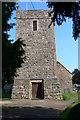
Early Medieval (Dark Age)Site Name: St Dogfan's (Llanrhaeadr ym Mochnant)Country: Wales County: Powys Type: Ancient Cross
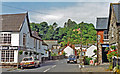
Nearest Town: Oswestry
Map Ref: SJ123260
Latitude: 52.824368N Longitude: 3.302961W
Condition:
| 5 | Perfect |
| 4 | Almost Perfect |
| 3 | Reasonable but with some damage |
| 2 | Ruined but still recognisable as an ancient site |
| 1 | Pretty much destroyed, possibly visible as crop marks |
| 0 | No data. |
| -1 | Completely destroyed |
| 5 | Superb |
| 4 | Good |
| 3 | Ordinary |
| 2 | Not Good |
| 1 | Awful |
| 0 | No data. |
| 5 | Can be driven to, probably with disabled access |
| 4 | Short walk on a footpath |
| 3 | Requiring a bit more of a walk |
| 2 | A long walk |
| 1 | In the middle of nowhere, a nightmare to find |
| 0 | No data. |
| 5 | co-ordinates taken by GPS or official recorded co-ordinates |
| 4 | co-ordinates scaled from a detailed map |
| 3 | co-ordinates scaled from a bad map |
| 2 | co-ordinates of the nearest village |
| 1 | co-ordinates of the nearest town |
| 0 | no data |
Internal Links:
External Links:
 (PID:18476)")
Part of 9th or 10th Century Cross Shaft, with 9th to 11th Century Cross Slab.
Access subject to church opening.
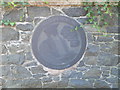
Information in the church reads: "There is also a large fragment of red sandstone, deeply carved, which must have come from Shropshire or Cheshire. It is part of a cylindrical 9th or 10th century shaft with angular fret...".
The larger slab has a whole A4 notice detailing its history
.
"The Cwgan Stone
The inscription on this stone reads
CO(CORG)OM FILIU(S) EDELSTAN
it is believed to commemorate a Cwgan, son of Edelstan"
The stone was discovered in the church fabric in the 1850s, and is now believed to be a 9th Century tomb stone reworked more elaorately in the 11th Century.
You may be viewing yesterday's version of this page. To see the most up to date information please register for a free account.
 (PID:231122)")
 (PID:18477)")
Do not use the above information on other web sites or publications without permission of the contributor.
Nearby Images from Geograph Britain and Ireland:

©2023(licence)

©2009(licence)
©2008(licence)
©2015(licence)
©2008(licence)
The above images may not be of the site on this page, they are loaded from Geograph.
Please Submit an Image of this site or go out and take one for us!
Click here to see more info for this site
Nearby sites
Key: Red: member's photo, Blue: 3rd party photo, Yellow: other image, Green: no photo - please go there and take one, Grey: site destroyed
Download sites to:
KML (Google Earth)
GPX (GPS waypoints)
CSV (Garmin/Navman)
CSV (Excel)
To unlock full downloads you need to sign up as a Contributory Member. Otherwise downloads are limited to 50 sites.
Turn off the page maps and other distractions
Nearby sites listing. In the following links * = Image available
262m ESE 111° Llanrhaeadr ym Mochnant (Standing Stone)* Standing Stone (Menhir) (SJ1254425902)
1.4km SE 125° Meusydd Henge Complex* Henge (SJ134252)
1.8km SE 129° Aber Rhaeadr* Standing Stone (Menhir) (SJ1369624820)
5.1km ESE 104° Llwyn Bryn Dinas* Hillfort (SJ172247)
5.4km WNW 288° Glan Hafon cairn* Cairn (SJ07152776)
6.4km NW 304° Afon Disgynfa* Cairn (SJ07042971)
6.7km W 278° Craig Rhiwarth* Hillfort (SJ057270)
6.7km SSE 165° St Myllin's Well* Holy Well or Sacred Spring (SJ1393819533)
6.8km WNW 286° Bedd Crynddyn* Cairn (SJ058280)
7.1km NNW 329° Cwm Maen Gwynedd Stone Row I Stone Row / Alignment (SJ0881132142)
7.1km NNW 330° Cwm Maen Gwynedd Stone Row II Stone Row / Alignment (SJ0885332238)
7.7km WNW 302° Rhos Y Beddau (Circle)* Stone Circle (SJ058302)
7.7km WNW 302° Rhos y Beddau (Rows)* Multiple Stone Rows / Avenue (SJ0579530205)
7.8km NW 304° Cwm Rhiwiau* Stone Circle (SJ059305)
7.9km WSW 248° St Illog's Well (Hirnant)* Holy Well or Sacred Spring (SJ04902313)
8.2km NW 315° Moel Sych* Cairn (SJ066319)
8.2km NW 321° Cader Berwyn Cairn 2* Cairn (SJ07173245)
8.4km NW 322° Cadair Berwyn* Cairn (SJ072327)
8.6km NNE 19° Cerrig Gwynion (Wrexham)* Hillfort (SJ152341)
8.7km NNW 328° Berwyn mountains Marker stones* Marker Stone (SJ078334)
8.8km NNW 329° Bwlch Maen Gwynedd* Cairn (SJ07953364)
8.9km ENE 75° St Silin's Well* Holy Well or Sacred Spring (SJ209282)
9.2km W 279° Craig ty-glas* Cairn (SJ03262758)
9.8km NNW 331° Bwrdd Arthur* Cairn (SJ077347)
9.9km W 277° Ffynnon Cwm Ewyn* Holy Well or Sacred Spring (SJ025273)
View more nearby sites and additional images

")
 We would like to know more about this location. Please feel free to add a brief description and any relevant information in your own language.
 Wir möchten mehr über diese Stätte erfahren. Bitte zögern Sie nicht, eine kurze Beschreibung und relevante Informationen in Deutsch hinzuzufügen.
 Nous aimerions en savoir encore un peu sur les lieux. S'il vous plaît n'hesitez pas à ajouter une courte description et tous les renseignements pertinents dans votre propre langue.
 Quisieramos informarnos un poco más de las lugares. No dude en añadir una breve descripción y otros datos relevantes en su propio idioma.