


<< Our Photo Pages >> Motilla del Azuer - Hillfort in Spain in Castilla La Mancha y Madrid
Submitted by Andy B on Saturday, 08 January 2011 Page Views: 8715
Iron Age and Later PrehistorySite Name: Motilla del AzuerCountry: Spain
NOTE: This site is 21.095 km away from the location you searched for.
Region: Castilla La Mancha y Madrid Type: Hillfort
Latitude: 39.043518N Longitude: 3.497643W
Condition:
| 5 | Perfect |
| 4 | Almost Perfect |
| 3 | Reasonable but with some damage |
| 2 | Ruined but still recognisable as an ancient site |
| 1 | Pretty much destroyed, possibly visible as crop marks |
| 0 | No data. |
| -1 | Completely destroyed |
| 5 | Superb |
| 4 | Good |
| 3 | Ordinary |
| 2 | Not Good |
| 1 | Awful |
| 0 | No data. |
| 5 | Can be driven to, probably with disabled access |
| 4 | Short walk on a footpath |
| 3 | Requiring a bit more of a walk |
| 2 | A long walk |
| 1 | In the middle of nowhere, a nightmare to find |
| 0 | No data. |
| 5 | co-ordinates taken by GPS or official recorded co-ordinates |
| 4 | co-ordinates scaled from a detailed map |
| 3 | co-ordinates scaled from a bad map |
| 2 | co-ordinates of the nearest village |
| 1 | co-ordinates of the nearest town |
| 0 | no data |
Be the first person to rate this site - see the 'Contribute!' box in the right hand menu.
Internal Links:
External Links:
I have visited· I would like to visit
Andy B has visited here
")
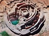
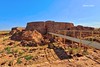
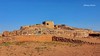
The sites, known as motillas, represent one of the most peculiar types of prehistoric settlements in the Iberian Peninsula. They occupied the region of La Mancha in the Bronze Age between 2200 and 1500 BC, and they are artificial mounds, 4 to 10 m high, a result of the destruction of a stone fortification of central plan with several concentric walled lines. Its distribution in the plain of La Mancha, with equidistanes of 4 to 5 kilometres, affects river meadows and low areas where the existence of pools was quite frequent until recent dates.
Although they were already known since the end of the 19th century, motillas were erroneously considered to be burial mounds until the middle of the seventies, when the start of the research work on the Motilla del Azuer carried out by the University of Granada showed that it was a fortification, surrounded by a small settlement and a necropolis. It is the first site of this kind to be excavated in a scientific and systematic way.
Technical features
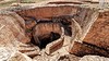
The mound of the fortification which has been recovered has a diameter of about 50 metres, and is composed of a tower, two walled enclosures and a large courtyard. The central core is composed of a tower of masonry of square plan, with 7 metres high east and west fronts and an interior accessible through ramps inlaid in narrow corridors, which confer a particular nature to the place.
The researchers explain that the settlement of the Azuer contains the oldest well found in the Iberian Peninsula. The inside of this type of walled enclosures protected basic resources such as water, collected from the phreatic stratum through the well, and was also used to store and process cereals on a large scale, to occasionally keep the livestock and to product pottery and other home-made products, whose remains have also been found.
Source: University of Granada - via Eureka Alert
Note: Bronze Age man suffered broken bone in neck, and lived
You may be viewing yesterday's version of this page. To see the most up to date information please register for a free account.
")
")
Do not use the above information on other web sites or publications without permission of the contributor.
Nearby Images from Flickr


The above images may not be of the site on this page, but were taken nearby. They are loaded from Flickr so please click on them for image credits.
Click here to see more info for this site
Nearby sites
Click here to view sites on an interactive map of the areaKey: Red: member's photo, Blue: 3rd party photo, Yellow: other image, Green: no photo - please go there and take one, Grey: site destroyed
Download sites to:
KML (Google Earth)
GPX (GPS waypoints)
CSV (Garmin/Navman)
CSV (Excel)
To unlock full downloads you need to sign up as a Contributory Member. Otherwise downloads are limited to 50 sites.
Turn off the page maps and other distractions
Nearby sites listing. In the following links * = Image available
32.1km SW 219° Cerro de La Encatada* Castro or Chafurdão
60.6km E 101° Cueva de Montesinos Cave or Rock Shelter
78.1km S 183° Los Escolares* Cave or Rock Shelter
96.4km SW 226° La Batanera Pinturas Rupestres Rock Art
96.7km SW 225° Cueva de Peña Escrita* Cave or Rock Shelter
98.9km WNW 282° Menhir de La Quinquiruela Standing Stone (Menhir)
101.2km NNW 334° Museo de Santa Cruz* Museum
118.3km S 187° Conjunto Arqueológico de Cástulo* Ancient Village or Settlement
122.1km ENE 58° Honrubia Castro or Chafurdão
131.2km SSE 167° Cámara Sepulcral Ibérica de Toya* Ancient Village or Settlement
133.0km N 6° Cuevas de Perales de Tajuña* Cave or Rock Shelter
133.0km NNW 343° Yacimiento Romano de Carranque Ancient Village or Settlement
134.5km S 179° La Cueva de la Graja* Rock Art
141.5km SSW 205° Cerrillo Blanco Ancient Village or Settlement
143.7km SSW 205° San Benito de Porcuna Ancient Village or Settlement
145.6km S 187° La Guardia de Jaén Catacumbas Ancient Village or Settlement
152.2km S 189° Dólmen del Collado de los Bastianes* Burial Chamber or Dolmen
152.8km SE 125° Yacimiento Prehistórico de Bagil Ancient Village or Settlement
152.8km SE 125° Dolmen de Bagil* Burial Chamber or Dolmen
154.3km N 354° Museo Arqueológico Nacional* Museum
154.7km N 353° Templo de Debod* Ancient Temple
155.7km ESE 108° Minetada Caves* Cave or Rock Shelter
156.1km NNW 329° Piedra Escrita* Standing Stone (Menhir)
156.2km WNW 297° La Estrella* Burial Chamber or Dolmen
159.0km NNW 329° Las Cogotas. Castro or Chafurdão
View more nearby sites and additional images


 We would like to know more about this location. Please feel free to add a brief description and any relevant information in your own language.
 Wir möchten mehr über diese Stätte erfahren. Bitte zögern Sie nicht, eine kurze Beschreibung und relevante Informationen in Deutsch hinzuzufügen.
 Nous aimerions en savoir encore un peu sur les lieux. S'il vous plaît n'hesitez pas à ajouter une courte description et tous les renseignements pertinents dans votre propre langue.
 Quisieramos informarnos un poco más de las lugares. No dude en añadir una breve descripción y otros datos relevantes en su propio idioma.