 with our Megalithic Portal iPhone app")


<< Our Photo Pages >> Salt Well (Grange) - Holy Well or Sacred Spring in England in Cumbria
Submitted by Anne T on Wednesday, 15 January 2020 Page Views: 1448
Springs and Holy WellsSite Name: Salt Well (Grange)Country: England
NOTE: This site is 5.406 km away from the location you searched for.
County: Cumbria Type: Holy Well or Sacred Spring
Nearest Town: Keswick Nearest Village: Grange
Map Ref: NY25161848
Latitude: 54.556003N Longitude: 3.158712W
Condition:
| 5 | Perfect |
| 4 | Almost Perfect |
| 3 | Reasonable but with some damage |
| 2 | Ruined but still recognisable as an ancient site |
| 1 | Pretty much destroyed, possibly visible as crop marks |
| 0 | No data. |
| -1 | Completely destroyed |
| 5 | Superb |
| 4 | Good |
| 3 | Ordinary |
| 2 | Not Good |
| 1 | Awful |
| 0 | No data. |
| 5 | Can be driven to, probably with disabled access |
| 4 | Short walk on a footpath |
| 3 | Requiring a bit more of a walk |
| 2 | A long walk |
| 1 | In the middle of nowhere, a nightmare to find |
| 0 | No data. |
| 5 | co-ordinates taken by GPS or official recorded co-ordinates |
| 4 | co-ordinates scaled from a detailed map |
| 3 | co-ordinates scaled from a bad map |
| 2 | co-ordinates of the nearest village |
| 1 | co-ordinates of the nearest town |
| 0 | no data |
Internal Links:
External Links:
 (PID:206735)")
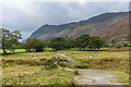
I found reference to this holy well, near Manesty, Grange, on Pastscape, which tells us this was listed as a holy well by W.T. McIntire in the Cumberland and Westmorland Antiquarian Society journal of 1944.
Also shown on the modern OS map, it is also recorded as the Salt Spring, Borrowdale by the Old Cumbria Gazetteer, which also has photographs of the well from 2009.
The Gazetter includes an entry from a Guide Book of 1787 by James Clark (A Survey of the Lakes of Cumberland, Westmorland and Lancashire), which tells us: "Below this house (Manesty) is Borrowdale-well, a medical water of excellent quality, and was formerly much frequented; it is a never failing cure for cutaneous eruptions in man or beast, by washing only … The water tastes very like sea water, is very clear and pellucid; but a kind of moss seems to arise with it, and remain upon the top like a scum."
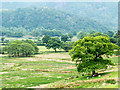
Located just off the Cumbria Way, we set off to find this salt spring, which was documented as having a low surrounding stone wall, just as dusk was rapidly falling. We got to within about 6m of the location of the well, using our GPS, but were unable to find the well structure.
The well is also documented in a paper entitled "A Salt Spring in Borrowdale" by Charlotte Kipling, Freshwater Biological Association (1961), available through the Archaological Data Service. There used to be a number of wells in this area. The monks from Furness Abbey are documented as having made salt from the salty waters of this well in medieval times, "a spring afterwards used by the German miners … for medicinal purposes".
You may be viewing yesterday's version of this page. To see the most up to date information please register for a free account.
 (PID:206734)")
Do not use the above information on other web sites or publications without permission of the contributor.
Nearby Images from Geograph Britain and Ireland:
©2016(licence)
©2018(licence)
©2019(licence)
©2016(licence)
©2018(licence)
The above images may not be of the site on this page, they are loaded from Geograph.
Please Submit an Image of this site or go out and take one for us!
Click here to see more info for this site
Nearby sites
Key: Red: member's photo, Blue: 3rd party photo, Yellow: other image, Green: no photo - please go there and take one, Grey: site destroyed
Download sites to:
KML (Google Earth)
GPX (GPS waypoints)
CSV (Garmin/Navman)
CSV (Excel)
To unlock full downloads you need to sign up as a Contributory Member. Otherwise downloads are limited to 50 sites.
Turn off the page maps and other distractions
Nearby sites listing. In the following links * = Image available
2.1km S 170° Bowder Stone* Natural Stone / Erratic / Other Natural Feature (NY255164)
2.1km S 173° Pocklington's Druid Stone* Modern Stone Circle etc (NY2539116369)
2.5km ESE 112° Reecastle Crag* Hillfort (NY275175)
2.6km S 185° Castle Crag Hillfort* Hillfort (NY249159)
3.4km NNE 28° Millennium Stone, Derwent Water* Modern Stone Circle etc (NY268215)
4.8km E 85° Shoulthwaite Hillfort* Hillfort (NY300188)
6.2km SSW 195° Borrowdale Stone Monument* Standing Stones (NY235125)
6.4km NE 36° Castlerigg W* Stone Circle (NY29062360)
6.5km NE 37° Castlerigg* Stone Circle (NY29132363)
6.7km SSW 192° Cappel-Crag/Seathwaite wall structure Misc. Earthwork (NY237119)
6.7km NE 53° Holy Well of St John the Baptist* Holy Well or Sacred Spring (NY30622245)
7.1km E 101° Brown How Ring Cairn* Ring Cairn (NY3208017008)
9.6km NE 53° Threlkeld Knott* Ancient Village or Settlement (NY330241)
10.1km S 189° Chapel Well, Smardale Holy Well or Sacred Spring (NY2350008550)
10.1km SSE 147° Grasmere - Far Easedale* Natural Stone / Erratic / Other Natural Feature (NY305099)
10.1km SE 131° Dunmail Raise* Round Cairn (NY32721170)
11.5km SSE 168° Langdale Axe Factory* Ancient Mine, Quarry or other Industry (NY274072)
11.6km SSW 212° Viking Timbers at St Olaf's Church Wasdale Head* Museum (NY18830869)
12.2km SE 134° Mêni Arthur Natural Stone / Erratic / Other Natural Feature (NY338099)
13.3km NNW 337° Castle How Fort Hillfort (NY201308)
13.3km SSE 164° Great Langdale* Rock Art (NY28650560)
13.6km SE 142° Allan Bank Cup Marked Stone* Rock Art (NY334076)
13.7km E 97° St Patrick's Well (Patterdale)* Holy Well or Sacred Spring (NY388166)
13.8km SE 140° Grasmere Cup-Marked Rocks* Rock Art (NY33850778)
14.0km NW 307° Stanger Spa* Holy Well or Sacred Spring (NY14122716)
View more nearby sites and additional images


 We would like to know more about this location. Please feel free to add a brief description and any relevant information in your own language.
 Wir möchten mehr über diese Stätte erfahren. Bitte zögern Sie nicht, eine kurze Beschreibung und relevante Informationen in Deutsch hinzuzufügen.
 Nous aimerions en savoir encore un peu sur les lieux. S'il vous plaît n'hesitez pas à ajouter une courte description et tous les renseignements pertinents dans votre propre langue.
 Quisieramos informarnos un poco más de las lugares. No dude en añadir una breve descripción y otros datos relevantes en su propio idioma.