

<< Our Photo Pages >> Rocher de Napoléon - Natural Stone / Erratic / Other Natural Feature in France in Bretagne:Côtes-D'Armor (22)
Submitted by regina on Saturday, 25 July 2020 Page Views: 703
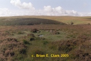
Natural PlacesSite Name: Rocher de Napoléon Alternative Name: Le Chapeau de Napoleon (Pors-Scaff)Country: France
NOTE: This site is 1.245 km away from the location you searched for.
Département: Bretagne:Côtes-D'Armor (22) Type: Natural Stone / Erratic / Other Natural Feature
Nearest Town: Plougrescant Nearest Village: Pors-scarff
Latitude: 48.856400N Longitude: 3.2473W
Condition:
| 5 | Perfect |
| 4 | Almost Perfect |
| 3 | Reasonable but with some damage |
| 2 | Ruined but still recognisable as an ancient site |
| 1 | Pretty much destroyed, possibly visible as crop marks |
| 0 | No data. |
| -1 | Completely destroyed |
| 5 | Superb |
| 4 | Good |
| 3 | Ordinary |
| 2 | Not Good |
| 1 | Awful |
| 0 | No data. |
| 5 | Can be driven to, probably with disabled access |
| 4 | Short walk on a footpath |
| 3 | Requiring a bit more of a walk |
| 2 | A long walk |
| 1 | In the middle of nowhere, a nightmare to find |
| 0 | No data. |
| 5 | co-ordinates taken by GPS or official recorded co-ordinates |
| 4 | co-ordinates scaled from a detailed map |
| 3 | co-ordinates scaled from a bad map |
| 2 | co-ordinates of the nearest village |
| 1 | co-ordinates of the nearest town |
| 0 | no data |
Internal Links:
External Links:
I have visited· I would like to visit
johnstone visited on 28th Jun 2023 - their rating: Cond: 3 Amb: 4 Access: 5
")
It's summit looks like Napoleon Bonaparte's cocked hat earning it an alternate name.
You may be viewing yesterday's version of this page. To see the most up to date information please register for a free account.
")
")
")
")
")
Do not use the above information on other web sites or publications without permission of the contributor.
Click here to see more info for this site
Nearby sites
Click here to view sites on an interactive map of the areaKey: Red: member's photo, Blue: 3rd party photo, Yellow: other image, Green: no photo - please go there and take one, Grey: site destroyed
Download sites to:
KML (Google Earth)
GPX (GPS waypoints)
CSV (Garmin/Navman)
CSV (Excel)
To unlock full downloads you need to sign up as a Contributory Member. Otherwise downloads are limited to 50 sites.
Turn off the page maps and other distractions
Nearby sites listing. In the following links * = Image available
1.1km S 190° Kergonet menhir* Standing Stone (Menhir)
4.6km SW 227° Menhir de Crec'h Bleiz Standing Stone (Menhir)
4.6km SW 214° Coffre de Roch Glaz* Cist
4.6km SW 214° Tossen-Keler Cromlech (post 2018)* Stone Circle
4.7km WSW 252° Dolmen de l'Ile-Saint-Gildas Burial Chamber or Dolmen
4.9km SSE 155° Menhir de Kerloc'h* Standing Stone (Menhir)
5.1km ESE 107° Men-ar-Rompet* Passage Grave
5.3km SW 234° Menhir de Kervéniou* Standing Stone (Menhir)
5.5km SW 224° Menhir de Kermarker* Standing Stone (Menhir)
5.8km SSE 167° Menhir de Kerriou* Standing Stone (Menhir)
5.8km SW 216° Kerpeulven Menhir (Penvénan)* Standing Stone (Menhir)
6.2km SW 223° Menhir de Kerbriand* Standing Stone (Menhir)
6.3km SW 234° Menhir de Kergastel* Standing Stone (Menhir)
7.9km SSE 167° Tossen-Keler Cromlech (1964-2018)* Stone Circle
8.1km SSW 213° Tossen-Keler Tumulus* Chambered Tomb
9.3km SW 230° Coat Mez allée couverte* Passage Grave
9.3km E 87° Tour-ar-Varquez* Stone Row / Alignment
9.8km E 89° Menhir de Poul-ar-Roué* Standing Stone (Menhir)
10.6km SSW 196° Menhir de Kerfos Standing Stone (Menhir)
10.7km SW 217° Menhir du Run* Standing Stone (Menhir)
12.2km E 95° Île-Coalen allée couverte* Passage Grave
12.7km S 187° Camp de Castel-Du Ancient Village or Settlement
13.6km ESE 110° Allée couverte de Mélus* Passage Grave
13.8km WSW 240° Stèle de Louannec* Standing Stone (Menhir)
16.1km SW 234° Dolmen dit le Lit de Saint-Yves* Burial Chamber or Dolmen
View more nearby sites and additional images


 We would like to know more about this location. Please feel free to add a brief description and any relevant information in your own language.
 Wir möchten mehr über diese Stätte erfahren. Bitte zögern Sie nicht, eine kurze Beschreibung und relevante Informationen in Deutsch hinzuzufügen.
 Nous aimerions en savoir encore un peu sur les lieux. S'il vous plaît n'hesitez pas à ajouter une courte description et tous les renseignements pertinents dans votre propre langue.
 Quisieramos informarnos un poco más de las lugares. No dude en añadir una breve descripción y otros datos relevantes en su propio idioma.