


<< Our Photo Pages >> St Silin's Well - Holy Well or Sacred Spring in Wales in Powys
Submitted by kiwiBetsy on Thursday, 02 December 2004 Page Views: 7987
Springs and Holy WellsSite Name: St Silin's WellCountry: Wales
NOTE: This site is 2.7 km away from the location you searched for.
County: Powys Type: Holy Well or Sacred Spring
Nearest Town: Oswestry Nearest Village: Llansilin
Map Ref: SJ209282
Latitude: 52.845473N Longitude: 3.175897W
Condition:
| 5 | Perfect |
| 4 | Almost Perfect |
| 3 | Reasonable but with some damage |
| 2 | Ruined but still recognisable as an ancient site |
| 1 | Pretty much destroyed, possibly visible as crop marks |
| 0 | No data. |
| -1 | Completely destroyed |
| 5 | Superb |
| 4 | Good |
| 3 | Ordinary |
| 2 | Not Good |
| 1 | Awful |
| 0 | No data. |
| 5 | Can be driven to, probably with disabled access |
| 4 | Short walk on a footpath |
| 3 | Requiring a bit more of a walk |
| 2 | A long walk |
| 1 | In the middle of nowhere, a nightmare to find |
| 0 | No data. |
| 5 | co-ordinates taken by GPS or official recorded co-ordinates |
| 4 | co-ordinates scaled from a detailed map |
| 3 | co-ordinates scaled from a bad map |
| 2 | co-ordinates of the nearest village |
| 1 | co-ordinates of the nearest town |
| 0 | no data |
Internal Links:
External Links:
")
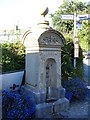
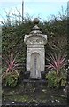
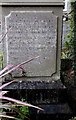
The fountain has it’s very own bank account under the care of “The Friends of the Fountain” so that it can pay it’s annual water bill to the Severn Trent Water Company and thus continue to quench the thirst of passers-by.
St. Silin was a shadowy figure of whom little is known.
You may be viewing yesterday's version of this page. To see the most up to date information please register for a free account.
Do not use the above information on other web sites or publications without permission of the contributor.
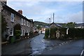
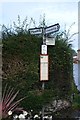
Nearby Images from Geograph Britain and Ireland:
©2007(licence)
©2020(licence)
©2020(licence)
©2020(licence)
©2020(licence)
The above images may not be of the site on this page, they are loaded from Geograph.
Please Submit an Image of this site or go out and take one for us!
Click here to see more info for this site
Nearby sites
Key: Red: member's photo, Blue: 3rd party photo, Yellow: other image, Green: no photo - please go there and take one, Grey: site destroyed
Download sites to:
KML (Google Earth)
GPX (GPS waypoints)
CSV (Garmin/Navman)
CSV (Excel)
To unlock full downloads you need to sign up as a Contributory Member. Otherwise downloads are limited to 50 sites.
Turn off the page maps and other distractions
Nearby sites listing. In the following links * = Image available
4.2km ENE 58° Cynynion Standing Stone* Standing Stone (Menhir) (SJ24503040)
5.0km E 98° Offa's Dyke north of Trefonen* Misc. Earthwork (SJ258274)
5.1km SW 226° Llwyn Bryn Dinas* Hillfort (SJ172247)
6.6km NE 44° Carreg y Big (Shropshire)* Standing Stone (Menhir) (SJ25623288)
7.5km NE 38° Selattyn Hill Ring Cairn* Ring Cairn (SJ256341)
7.6km E 81° St Oswald's Well (Oswestry)* Holy Well or Sacred Spring (SJ284293)
7.9km WSW 244° Aber Rhaeadr* Standing Stone (Menhir) (SJ1369624820)
8.0km NNW 334° Tomen y Gwyddel* Round Cairn (SJ175355)
8.1km WSW 247° Meusydd Henge Complex* Henge (SJ134252)
8.2km NW 315° Cerrig Gwynion (Wrexham)* Hillfort (SJ152341)
8.3km SE 137° Llanymynech Hill Hillfort (SJ265220)
8.6km WSW 254° Llanrhaeadr ym Mochnant (Standing Stone)* Standing Stone (Menhir) (SJ1254425902)
8.9km WSW 255° St Dogfan's (Llanrhaeadr ym Mochnant)* Ancient Cross (SJ123260)
9.0km ENE 71° Old Oswestry Fort* Hillfort (SJ295310)
9.4km NW 326° Carnedd Rhys Goch* Cairn (SJ15763613)
10.4km N 6° Llwynmawr* Standing Stone (Menhir) (SJ2211138530)
10.9km NNW 334° Tomen y Meirw* Round Barrow(s) (SJ162381)
11.1km SW 218° St Myllin's Well* Holy Well or Sacred Spring (SJ1393819533)
11.7km N 6° Careg y Big (Llangollen)* Standing Stone (Menhir) (SJ224398)
11.7km S 174° Collfryn Ring Ditch Misc. Earthwork (SJ21861650)
11.9km ESE 107° St Winifred's Well* Holy Well or Sacred Spring (SJ3222624437)
12.0km ENE 74° Whittington Castle* Artificial Mound (SJ325313)
12.4km NNW 341° Vivod Mountain Cairn (SJ16964000)
12.6km NNW 343° Nant-Y-Bache Round Barrow(s) (SJ17474031)
12.6km NNW 346° Blaen Nant* Round Barrow(s) (SJ18144051)
View more nearby sites and additional images


 We would like to know more about this location. Please feel free to add a brief description and any relevant information in your own language.
 Wir möchten mehr über diese Stätte erfahren. Bitte zögern Sie nicht, eine kurze Beschreibung und relevante Informationen in Deutsch hinzuzufügen.
 Nous aimerions en savoir encore un peu sur les lieux. S'il vous plaît n'hesitez pas à ajouter une courte description et tous les renseignements pertinents dans votre propre langue.
 Quisieramos informarnos un poco más de las lugares. No dude en añadir una breve descripción y otros datos relevantes en su propio idioma.