

, Aubrey Burl")
<< Our Photo Pages >> Salcombe Hill Standing Stone - Standing Stone (Menhir) in England in Devon
Submitted by maengurta on Tuesday, 17 April 2018 Page Views: 1981
Neolithic and Bronze AgeSite Name: Salcombe Hill Standing StoneCountry: England
NOTE: This site is 0.669 km away from the location you searched for.
County: Devon Type: Standing Stone (Menhir)
Nearest Town: Sidmouth Nearest Village: Salcombe Regis
Map Ref: SY142885
Latitude: 50.689800N Longitude: 3.216016W
Condition:
| 5 | Perfect |
| 4 | Almost Perfect |
| 3 | Reasonable but with some damage |
| 2 | Ruined but still recognisable as an ancient site |
| 1 | Pretty much destroyed, possibly visible as crop marks |
| 0 | No data. |
| -1 | Completely destroyed |
| 5 | Superb |
| 4 | Good |
| 3 | Ordinary |
| 2 | Not Good |
| 1 | Awful |
| 0 | No data. |
| 5 | Can be driven to, probably with disabled access |
| 4 | Short walk on a footpath |
| 3 | Requiring a bit more of a walk |
| 2 | A long walk |
| 1 | In the middle of nowhere, a nightmare to find |
| 0 | No data. |
| 5 | co-ordinates taken by GPS or official recorded co-ordinates |
| 4 | co-ordinates scaled from a detailed map |
| 3 | co-ordinates scaled from a bad map |
| 2 | co-ordinates of the nearest village |
| 1 | co-ordinates of the nearest town |
| 0 | no data |
Internal Links:
External Links:
I have visited· I would like to visit
lauraaurora visited on 23rd Oct 2022 - their rating: Cond: 2 Amb: 3 Access: 4
")
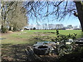
I found out about this stone some years ago as it was marked "Standing Stone" on the 1889 25" to the mile OS map and is still marked on the latest 1:2500 OS Masterplan.
It was apparently still standing and marked on maps until the mid 1950's until it either fell or was purposefully removed and dumped in an adjacent hedge a little to the North East of its original location. This operation damaged the stone breaking a chunk of approximately 70cm from the top. The broken portion lies propped up against the main mass which measures approx 200cm (tape in photos set at 200cm). It could have originally stood about 180-200cm.
Easily accessible from Salcombe Hill where there is ample parking and a layby very close by, the stone is on National Trust land beside a bridleway called Milltown Lane. The 1889 map also showed another standing stone nearby which I have also located but this one was not marked on subsequent editions of OS maps.
Perhaps the National Trust would be interested in repairing and reinstating this stone as part of its heritage and conservation commitments...
More details at....
http://www.heritagegateway.org.uk/Gateway/Results_Single.aspx?uid=MDV14495&resourceID=104
You may be viewing yesterday's version of this page. To see the most up to date information please register for a free account.
")
")
Do not use the above information on other web sites or publications without permission of the contributor.
Nearby Images from Geograph Britain and Ireland:
©2011(licence)
©2014(licence)
©2022(licence)
©2014(licence)
©2018(licence)
The above images may not be of the site on this page, they are loaded from Geograph.
Please Submit an Image of this site or go out and take one for us!
Click here to see more info for this site
Nearby sites
Key: Red: member's photo, Blue: 3rd party photo, Yellow: other image, Green: no photo - please go there and take one, Grey: site destroyed
Download sites to:
KML (Google Earth)
GPX (GPS waypoints)
CSV (Garmin/Navman)
CSV (Excel)
To unlock full downloads you need to sign up as a Contributory Member. Otherwise downloads are limited to 50 sites.
Turn off the page maps and other distractions
Nearby sites listing. In the following links * = Image available
2.0km SW 236° Sidmouth Museum* Museum (SY125874)
3.1km NNW 334° Sidbury Castle* Hillfort (SY129913)
3.5km WSW 259° Seven Stones (Devon)* Stone Circle (SY10758787)
4.7km SW 235° High Peak* Ancient Village or Settlement (SY103859)
5.7km NNE 31° Broad Down Stone Circle (SY172933)
5.9km NE 48° Blackbury Camp* Hillfort (SY187924)
6.3km NNE 28° Broad Down* Barrow Cemetery (SY173940)
7.2km NNE 14° Farway Castle Henge (SY1606395499)
7.5km N 9° Ring-in-the-Mire* Misc. Earthwork (SY1548695932)
7.7km N 2° Farway & Gittisham Hill Cemetery* Barrow Cemetery (SY146962)
9.1km WNW 289° Aylesbeare Common tumulus* Round Barrow(s) (SY056916)
9.2km W 262° Tor Barrow (Colaton Raleigh Common) Round Barrow(s) (SY05088737)
9.8km ENE 69° Seaton Down Camp* Hillfort (SY23449185)
11.0km W 263° Woodbury Castle* Hillfort (SY032874)
11.8km ENE 61° Colyton Church Cross* Ancient Cross (SY24599409)
12.4km ENE 75° Hawksdown Camp Hillfort (SY26299143)
14.9km NNW 348° Hembury Fort* Hillfort (ST113031)
15.0km ENE 67° Musbury Castle* Hillfort (SY282941)
15.9km NNE 11° Dumpdon Great Camp* Hillfort (ST176040)
16.4km NNE 30° Stockland Great Castle* Hillfort (ST22620262)
16.7km ENE 73° Shapwick Hill Bowl Barrows Barrow Cemetery (SY303930)
17.1km N 356° Row Barrow (Devon)* Round Barrow(s) (ST13180561)
17.4km W 266° Topsham Museum* Museum (SX9673987646)
17.5km NNE 29° Stockland Little Castle Hillfort (ST22980362)
18.4km NE 56° Axminster Castle* Hillfort (SY296986)
View more nearby sites and additional images


 We would like to know more about this location. Please feel free to add a brief description and any relevant information in your own language.
 Wir möchten mehr über diese Stätte erfahren. Bitte zögern Sie nicht, eine kurze Beschreibung und relevante Informationen in Deutsch hinzuzufügen.
 Nous aimerions en savoir encore un peu sur les lieux. S'il vous plaît n'hesitez pas à ajouter une courte description et tous les renseignements pertinents dans votre propre langue.
 Quisieramos informarnos un poco más de las lugares. No dude en añadir una breve descripción y otros datos relevantes en su propio idioma.