

<< Our Photo Pages >> Devil's Whispering Well - Holy Well or Sacred Spring in England in Somerset
Submitted by HOLYWELL on Monday, 18 February 2008 Page Views: 6606
Springs and Holy WellsSite Name: Devil's Whispering WellCountry: England
NOTE: This site is 1.254 km away from the location you searched for.
County: Somerset Type: Holy Well or Sacred Spring
Nearest Village: Bishop's Lydeard
Map Ref: ST1671029841
Latitude: 51.061842N Longitude: 3.189921W
Condition:
| 5 | Perfect |
| 4 | Almost Perfect |
| 3 | Reasonable but with some damage |
| 2 | Ruined but still recognisable as an ancient site |
| 1 | Pretty much destroyed, possibly visible as crop marks |
| 0 | No data. |
| -1 | Completely destroyed |
| 5 | Superb |
| 4 | Good |
| 3 | Ordinary |
| 2 | Not Good |
| 1 | Awful |
| 0 | No data. |
| 5 | Can be driven to, probably with disabled access |
| 4 | Short walk on a footpath |
| 3 | Requiring a bit more of a walk |
| 2 | A long walk |
| 1 | In the middle of nowhere, a nightmare to find |
| 0 | No data. |
| 5 | co-ordinates taken by GPS or official recorded co-ordinates |
| 4 | co-ordinates scaled from a detailed map |
| 3 | co-ordinates scaled from a bad map |
| 2 | co-ordinates of the nearest village |
| 1 | co-ordinates of the nearest town |
| 0 | no data |
Be the first person to rate this site - see the 'Contribute!' box in the right hand menu.
Internal Links:
External Links:
")
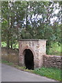
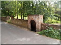
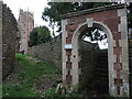
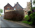
Apparently curses could be whispered here into this roadside well. This is interesting as the chamber is at an angle as if you could whisper without being seen! It is a large structure about five foot high and is found West Street.
You may be viewing yesterday's version of this page. To see the most up to date information please register for a free account.
")
Do not use the above information on other web sites or publications without permission of the contributor.
Nearby Images from Geograph Britain and Ireland:
©2011(licence)
©2013(licence)
©2024(licence)
©2011(licence)
©2013(licence)
The above images may not be of the site on this page, they are loaded from Geograph.
Please Submit an Image of this site or go out and take one for us!
Click here to see more info for this site
Nearby sites
Key: Red: member's photo, Blue: 3rd party photo, Yellow: other image, Green: no photo - please go there and take one, Grey: site destroyed
Download sites to:
KML (Google Earth)
GPX (GPS waypoints)
CSV (Garmin/Navman)
CSV (Excel)
To unlock full downloads you need to sign up as a Contributory Member. Otherwise downloads are limited to 50 sites.
Turn off the page maps and other distractions
Nearby sites listing. In the following links * = Image available
2.6km NE 39° St. Agnes Well* Holy Well or Sacred Spring (ST18423186)
4.6km SE 140° Norton Fitzwarren* Hillfort (ST196263)
5.3km N 357° Wills Neck* Barrow Cemetery (ST16533516)
6.1km N 356° Triscombe Stone* Standing Stone (Menhir) (ST16363592)
6.5km N 350° Great Hill Platform cairn* Barrow Cemetery (ST15653625)
6.6km NNE 14° Plainsfield Camp* Misc. Earthwork (ST18433622)
7.2km WSW 256° Kings Castle Hillfort (ST097282)
7.4km NNW 345° Fire Beacon Cairn* Cairn (ST14913697)
7.4km N 349° West Hill Platform Cairn* Cairn (ST15423717)
7.8km SE 131° Museum of Somerset* Museum (ST225246)
8.3km N 356° Dead Woman's Ditch* Misc. Earthwork (ST162381)
8.4km N 349° Wilmots Pool Cairn* Cairn (ST15303813)
8.6km NNW 345° Black Hill Tumuli* Barrow Cemetery (ST14653819)
8.6km NNW 342° Hurley Beacon Tumulus* Cairn (ST14223808)
9.4km N 355° Dowsborough Castle* Hillfort (ST160392)
9.5km NNW 341° Halsway Tumuli* Barrow Cemetery (ST137389)
9.9km NNW 338° Thorncombe Hill Cairns* Barrow Cemetery (ST13183914)
10.4km NNW 337° Thorncombe Barrow* Cairn (ST12733942)
10.4km ESE 119° Cambria Farm Ancient Village or Settlement (ST257246)
10.5km WNW 291° Elworthy Barrows hillfort* Hillfort (ST070338)
10.7km NNW 332° Trendle Ring* Ancient Village or Settlement (ST118394)
10.8km NW 322° Curdon Camp Hillfort (ST102385)
11.2km NNW 346° Holford Standing Stone* Standing Stone (Menhir) (ST142408)
12.0km NNW 338° Beacon Hill Platform Cairn* Barrow Cemetery (ST12434101)
12.3km WSW 243° Castles Camp Hillfort (ST057244)
View more nearby sites and additional images


 We would like to know more about this location. Please feel free to add a brief description and any relevant information in your own language.
 Wir möchten mehr über diese Stätte erfahren. Bitte zögern Sie nicht, eine kurze Beschreibung und relevante Informationen in Deutsch hinzuzufügen.
 Nous aimerions en savoir encore un peu sur les lieux. S'il vous plaît n'hesitez pas à ajouter une courte description et tous les renseignements pertinents dans votre propre langue.
 Quisieramos informarnos un poco más de las lugares. No dude en añadir una breve descripción y otros datos relevantes en su propio idioma.