


<< Other Photo Pages >> Rhos-Crug Barrows I and II - Round Barrow(s) in Wales in Powys
Submitted by jfarrar on Friday, 06 May 2016 Page Views: 1647
Neolithic and Bronze AgeSite Name: Rhos-Crug Barrows I and IICountry: Wales
NOTE: This site is 1.808 km away from the location you searched for.
County: Powys Type: Round Barrow(s)
Nearest Town: Llanbister
Map Ref: SO167743
Latitude: 52.360402N Longitude: 3.224651W
Condition:
| 5 | Perfect |
| 4 | Almost Perfect |
| 3 | Reasonable but with some damage |
| 2 | Ruined but still recognisable as an ancient site |
| 1 | Pretty much destroyed, possibly visible as crop marks |
| 0 | No data. |
| -1 | Completely destroyed |
| 5 | Superb |
| 4 | Good |
| 3 | Ordinary |
| 2 | Not Good |
| 1 | Awful |
| 0 | No data. |
| 5 | Can be driven to, probably with disabled access |
| 4 | Short walk on a footpath |
| 3 | Requiring a bit more of a walk |
| 2 | A long walk |
| 1 | In the middle of nowhere, a nightmare to find |
| 0 | No data. |
| 5 | co-ordinates taken by GPS or official recorded co-ordinates |
| 4 | co-ordinates scaled from a detailed map |
| 3 | co-ordinates scaled from a bad map |
| 2 | co-ordinates of the nearest village |
| 1 | co-ordinates of the nearest town |
| 0 | no data |
Internal Links:
External Links:
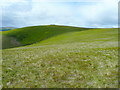
Rhos Crug I
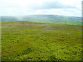
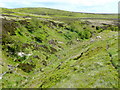
Round barrow on the summit of Rhos Crug. It is slightly oval in plan, with a length of 17m, width of 15.6m and height of 1.8m. There is a long depression, running for 2.8m E-W in the centre of the mound, suggesting that robbing has taken place. A square hole is also present halfway up the eastern side of the mound. There are no visible indications of a ditch (Cadw, 1998).
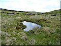
Larger and westernmost of a pair of barrows, together with PRN 1110. Sited on local summit with extensive views all around, 17m diam x 1.8m high. Generally well-preserved with flattish summit on which is a linear depression E-W c 3m long x 1m wide x 0.5m deep. A recent square pit 0.5 x 0.5 x 0.4m has been dug in NE side, possibly as a result of metal detector. Possible peat deposits over 100m to N (CPAT, 2001).
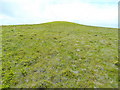
Rhos Crug II
Barrow on the summit of Rhos Crug. It has a diameter of 13m and is 1.5m high. An erosion scar 2.8m long runs across the northern edge of the summit. No remains of an encircling ditch (Cadw, 1998).
Smaller and easternmost of a pair of barrows together with PRN 1109. Generally well-preserved but with slight sheep scour on summit. No obvious robbing. Sited on local summit with extensive views all around, 13m diam x 1.6m high, rounded profile. Possible peat deposits over 100m to N (CPAT, 2001)
You may be viewing yesterday's version of this page. To see the most up to date information please register for a free account.
Do not use the above information on other web sites or publications without permission of the contributor.
Nearby Images from Geograph Britain and Ireland:
©2009(licence)
©2009(licence)
©2009(licence)
©2009(licence)
©2009(licence)
The above images may not be of the site on this page, they are loaded from Geograph.
Please Submit an Image of this site or go out and take one for us!
Click here to see more info for this site
Nearby sites
Key: Red: member's photo, Blue: 3rd party photo, Yellow: other image, Green: no photo - please go there and take one, Grey: site destroyed
Download sites to:
KML (Google Earth)
GPX (GPS waypoints)
CSV (Garmin/Navman)
CSV (Excel)
To unlock full downloads you need to sign up as a Contributory Member. Otherwise downloads are limited to 50 sites.
Turn off the page maps and other distractions
Nearby sites listing. In the following links * = Image available
7.1km W 269° St Anno's Church (Llannano)* Misc. Earthwork (SO0956874345)
9.0km S 187° Shepherd's Tump* Round Barrow(s) (SO155654)
9.3km N 10° Grey Stones* Stone Circle (SO185834)
9.4km S 174° Cwm Bwch Barrows* Round Barrow(s) (SO175649)
9.6km NW 323° Rhiw Porthnant* Barrow Cemetery (SO111821)
9.7km ENE 63° Offa's Dyke west of Llanfair Hill Misc. Earthwork (SO25407862)
10.4km SSE 163° Black Mixen Barrows* Round Barrow(s) (SO196643)
10.4km NE 56° Llanfair Hill North Standing Stone (Menhir) (SO25428006)
10.8km ESE 123° St Mary (Pilleth)* Holy Well or Sacred Spring (SO25636824)
11.3km ESE 102° Jacket's Well, The Jackets, Jackets Well* Holy Well or Sacred Spring (SO2776271836)
11.3km ENE 62° Llanfair Hill East Standing Stone (Menhir) (SO26797950)
11.6km SSE 155° Bach Hill Barrows* Round Barrow(s) (SO21396365)
11.7km NE 44° Fron Camp* Hillfort (SO250826)
11.8km N 354° Kerry Hill* Stone Circle (SO15768607)
11.9km NNW 334° Two Tumps* Round Barrow(s) (SO11688505)
11.9km NNW 329° Kerry Ridgeway* Ancient Trackway (SO108846)
11.9km SSE 159° Whinyard Rocks Barrows* Round Barrow(s) (SO207631)
11.9km E 98° Offa's Dyke Centre* Museum (SO2850172430)
11.9km N 355° Shenton's Tump Barrow* Round Barrow(s) (SO15848622)
12.3km SSE 161° Whimble Barrow* Round Barrow(s) (SO205626)
12.8km WSW 247° Camlo Hill Stone* Standing Stone (Menhir) (SO048696)
12.8km NNW 340° Gwernescob Round Barrow(s) (SO12578647)
12.9km NNW 340° Caebetin Hill Timber Circle (SO126865)
12.9km WSW 248° Llyn Dwr Cairn* Cairn (SO04676962)
13.0km ENE 70° Rockhill Iron Age Enclosure* Misc. Earthwork (SO290785)
View more nearby sites and additional images


 We would like to know more about this location. Please feel free to add a brief description and any relevant information in your own language.
 Wir möchten mehr über diese Stätte erfahren. Bitte zögern Sie nicht, eine kurze Beschreibung und relevante Informationen in Deutsch hinzuzufügen.
 Nous aimerions en savoir encore un peu sur les lieux. S'il vous plaît n'hesitez pas à ajouter une courte description et tous les renseignements pertinents dans votre propre langue.
 Quisieramos informarnos un poco más de las lugares. No dude en añadir una breve descripción y otros datos relevantes en su propio idioma.