


<< Our Photo Pages >> Tossen-Keler Cromlech (1964-2018) - Stone Circle in France in Bretagne:Côtes-D'Armor (22)
Submitted by TheCaptain on Friday, 25 May 2007 Page Views: 6132
Neolithic and Bronze AgeSite Name: Tossen-Keler Cromlech (1964-2018)Country: France
NOTE: This site is 5.24 km away from the location you searched for.
Département: Bretagne:Côtes-D'Armor (22) Type: Stone Circle
Nearest Town: Tréguier Nearest Village: Tréguier
Latitude: 48.787300N Longitude: 3.224W
Condition:
| 5 | Perfect |
| 4 | Almost Perfect |
| 3 | Reasonable but with some damage |
| 2 | Ruined but still recognisable as an ancient site |
| 1 | Pretty much destroyed, possibly visible as crop marks |
| 0 | No data. |
| -1 | Completely destroyed |
| 5 | Superb |
| 4 | Good |
| 3 | Ordinary |
| 2 | Not Good |
| 1 | Awful |
| 0 | No data. |
| 5 | Can be driven to, probably with disabled access |
| 4 | Short walk on a footpath |
| 3 | Requiring a bit more of a walk |
| 2 | A long walk |
| 1 | In the middle of nowhere, a nightmare to find |
| 0 | No data. |
| 5 | co-ordinates taken by GPS or official recorded co-ordinates |
| 4 | co-ordinates scaled from a detailed map |
| 3 | co-ordinates scaled from a bad map |
| 2 | co-ordinates of the nearest village |
| 1 | co-ordinates of the nearest town |
| 0 | no data |
Internal Links:
External Links:
I have visited· I would like to visit
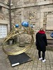
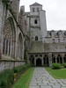
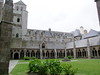
TheCaptain visited on 17th Apr 2014 - their rating: Cond: 3 Amb: 2 Access: 5 Following lunch in the old town at Treguier we were then heading north along the river to go and sort out the Roche Jaune menhir quandary, so first did a little detour by dropping down from the old town to the quayside for a quick look at the Tossen Keler cromlech.
Poor thing is looking very unloved today, with vehicles parked all around it and various funfair or market stalls nearby. In this situation, it looks not much more than a load of big stones used to divide up the quayside into carpark, boatyard, and other areas. What a shame. Dad was asking why it has been moved here, and I have to say, I still have absolutely no idea.
TheCaptain visited on 25th Jun 2005 - their rating: Cond: 3 Amb: 2 Access: 5 For a reason unknown to me, the 40 metre diameter and 7 metres high Tossen Keler tumulus from Penvénan was excavated and totally removed in about 1960. The horseshoe of stones (cromlech) that surrounded it were moved to a position in a little public garden on the quayside here at the pleasant old port town of Tréguier. Much of the horseshoe is here, but there was once a few stones with engravings on them, which are now in some museum or other somewhere, and have been replaced here with more modern stones.
I remember this as a pleasant grassy park from my previous visit, but when I revisited in 2005, apart from the grass within it, it is in a massive dusty car and bus park, looking very unloved. Its a shame.
TheCaptain visited on 25th Jun 1995 - their rating: Access: 5 Cross Channel sailing trip from Plymouth, after a 19 hour crossing in rough conditions we berthed in Treguier for some well deserved rest and relaxation. The remains of this cromlech have been positioned on the quayside.
Average ratings for this site from all visit loggers: Condition: 3 Ambience: 2 Access: 5
 (PID:30073)")
Much of the horseshoe was here, but there was once a few stones with engravings on them, which are now in some museum or other somewhere, and have been replaced here with more modern stones.
I remember this as a pleasant grassy park from my previous visit (having sailed to Trégier), but when I revisited in 2005, apart from the grass within it, it is in a massive dusty car and bus park, looking very unloved. Its a shame.
From http://ville-penvenan.com/loisir-culture/patrimoine/tumulus
"After excavations in 1964, the stones from the Tumulus belt were installed on the quays of Tréguier. In June 2018, they returned to their home town on the site of the chapel of Saint Gonval."
You may be viewing yesterday's version of this page. To see the most up to date information please register for a free account.
 (PID:30064)")
 (PID:30072)")
 (PID:30071)")
Do not use the above information on other web sites or publications without permission of the contributor.
Nearby Images from Flickr
The above images may not be of the site on this page, but were taken nearby. They are loaded from Flickr so please click on them for image credits.
Click here to see more info for this site
Nearby sites
Click here to view sites on an interactive map of the areaKey: Red: member's photo, Blue: 3rd party photo, Yellow: other image, Green: no photo - please go there and take one, Grey: site destroyed
Download sites to:
KML (Google Earth)
GPX (GPS waypoints)
CSV (Garmin/Navman)
CSV (Excel)
To unlock full downloads you need to sign up as a Contributory Member. Otherwise downloads are limited to 50 sites.
Turn off the page maps and other distractions
Nearby sites listing. In the following links * = Image available
2.1km N 349° Menhir de Kerriou* Standing Stone (Menhir)
3.3km N 7° Menhir de Kerloc'h* Standing Stone (Menhir)
5.2km WSW 242° Menhir de Kerfos Standing Stone (Menhir)
5.8km NW 312° Tossen-Keler Cromlech (post 2018)* Stone Circle
5.8km NW 312° Coffre de Roch Glaz* Cist
5.9km SW 214° Camp de Castel-Du Ancient Village or Settlement
5.9km WNW 300° Kerpeulven Menhir (Penvénan)* Standing Stone (Menhir)
6.2km W 278° Tossen-Keler Tumulus* Chambered Tomb
6.6km NW 304° Menhir de Kermarker* Standing Stone (Menhir)
6.7km WNW 298° Menhir de Kerbriand* Standing Stone (Menhir)
6.8km NW 312° Menhir de Crec'h Bleiz Standing Stone (Menhir)
6.9km NNW 344° Kergonet menhir* Standing Stone (Menhir)
7.0km NNE 27° Men-ar-Rompet* Passage Grave
7.5km NW 307° Menhir de Kervéniou* Standing Stone (Menhir)
7.9km NNW 347° Rocher de Napoléon* Natural Stone / Erratic / Other Natural Feature
7.9km WNW 300° Menhir de Kergastel* Standing Stone (Menhir)
8.2km W 264° Menhir du Run* Standing Stone (Menhir)
8.8km NW 315° Dolmen de l'Ile-Saint-Gildas Burial Chamber or Dolmen
9.1km W 281° Coat Mez allée couverte* Passage Grave
11.2km NE 43° Tour-ar-Varquez* Stone Row / Alignment
11.2km NE 46° Menhir de Poul-ar-Roué* Standing Stone (Menhir)
11.4km SSW 206° Manoir de Coadélan menhir* Standing Stone (Menhir)
11.5km ENE 74° Allée couverte de Mélus* Passage Grave
12.4km ENE 57° Île-Coalen allée couverte* Passage Grave
13.7km W 274° Stèle de Louannec* Standing Stone (Menhir)
View more nearby sites and additional images


 We would like to know more about this location. Please feel free to add a brief description and any relevant information in your own language.
 Wir möchten mehr über diese Stätte erfahren. Bitte zögern Sie nicht, eine kurze Beschreibung und relevante Informationen in Deutsch hinzuzufügen.
 Nous aimerions en savoir encore un peu sur les lieux. S'il vous plaît n'hesitez pas à ajouter une courte description et tous les renseignements pertinents dans votre propre langue.
 Quisieramos informarnos un poco más de las lugares. No dude en añadir una breve descripción y otros datos relevantes en su propio idioma.