

<< Our Photo Pages >> Roundstone Wood - Modern Stone Circle etc in Wales in South Glamorgan
Submitted by Andy B on Sunday, 12 November 2006 Page Views: 11912
Modern SitesSite Name: Roundstone Wood Alternative Name: Torchwood Stone CircleCountry: Wales County: South Glamorgan Type: Modern Stone Circle etc
Nearest Town: Cardiff
Map Ref: ST192746
Latitude: 51.464581N Longitude: 3.164525W
Condition:
| 5 | Perfect |
| 4 | Almost Perfect |
| 3 | Reasonable but with some damage |
| 2 | Ruined but still recognisable as an ancient site |
| 1 | Pretty much destroyed, possibly visible as crop marks |
| 0 | No data. |
| -1 | Completely destroyed |
| 5 | Superb |
| 4 | Good |
| 3 | Ordinary |
| 2 | Not Good |
| 1 | Awful |
| 0 | No data. |
| 5 | Can be driven to, probably with disabled access |
| 4 | Short walk on a footpath |
| 3 | Requiring a bit more of a walk |
| 2 | A long walk |
| 1 | In the middle of nowhere, a nightmare to find |
| 0 | No data. |
| 5 | co-ordinates taken by GPS or official recorded co-ordinates |
| 4 | co-ordinates scaled from a detailed map |
| 3 | co-ordinates scaled from a bad map |
| 2 | co-ordinates of the nearest village |
| 1 | co-ordinates of the nearest town |
| 0 | no data |
Internal Links:
External Links:
I have visited· I would like to visit
Andy B has visited here
")
The fictional school featured in the episode is even called Coed y Carreg! (Wood of the Circle).
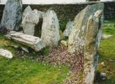
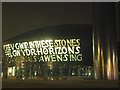
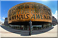
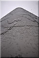
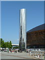
The stone circle looks fake as the edges on the stones look too sharp. I've put as a grid reference the location of the Wales Millenium Centre as it seemed most appropriate, but there is of course no stone circle there, just a time rift!
You may be viewing yesterday's version of this page. To see the most up to date information please register for a free account.
Do not use the above information on other web sites or publications without permission of the contributor.
Nearby Images from Geograph Britain and Ireland:
©2007(licence)
©2010(licence)
©2012(licence)
©2014(licence)
©2016(licence)
The above images may not be of the site on this page, they are loaded from Geograph.
Please Submit an Image of this site or go out and take one for us!
Click here to see more info for this site
Nearby sites
Key: Red: member's photo, Blue: 3rd party photo, Yellow: other image, Green: no photo - please go there and take one, Grey: site destroyed
Download sites to:
KML (Google Earth)
GPX (GPS waypoints)
CSV (Garmin/Navman)
CSV (Excel)
To unlock full downloads you need to sign up as a Contributory Member. Otherwise downloads are limited to 50 sites.
Turn off the page maps and other distractions
Nearby sites listing. In the following links * = Image available
2.3km N 351° Replica of St Lythans Tomb* Modern Stone Circle etc (ST1886176913)
2.4km NW 323° Gorsedd Circle (Bute Park)* Modern Stone Circle etc (ST178765)
2.4km NNW 339° Gorsedd Circle (National Museum)* Modern Stone Circle etc (ST18387689)
2.5km NNW 339° National Museum Cardiff* Museum (ST18357696)
3.8km W 268° Leckwith Round Barrow(s) (ST154745)
5.0km NW 313° St Teilo's Well, Llandaff* Holy Well or Sacred Spring (ST15567805)
5.4km WSW 255° Cwrt-yr-ala Hillfort (ST139733)
5.8km W 273° Caerau (Cardiff)* Hillfort (ST13377498)
5.9km W 263° Coed-y Cymdda Hillfort (ST13297398)
6.9km S 191° St Marys Well Holy Well or Sacred Spring (ST17796785)
7.4km NW 312° Pistyll Golau Holy Well or Sacred Spring (ST13787962)
7.7km WNW 288° St Fagan's Well Holy Well or Sacred Spring (ST11917712)
7.7km W 262° Quarrymen Stone* Modern Stone Circle etc (ST115736)
7.9km NW 312° Radyr Woods Burnt Mound* Artificial Mound (ST13438003)
7.9km WNW 288° Museum of Welsh Life, St Fagans* Museum (ST117772)
8.0km SSW 196° Sully Island Promontory Fort Promontory Fort / Cliff Castle (ST16876697)
8.0km SSW 196° Sully Island Mound Round Barrow(s) (ST16936692)
8.0km W 261° Marsyd Round Barrow(s) (ST11217352)
8.1km SW 235° Pencoetre Wood Barrow Round Barrow(s) (ST125701)
8.5km W 265° Vianshill Round Barrow(s) (ST10717401)
8.5km W 263° St Lythans Down Round Barrow* Round Barrow(s) (ST10717367)
8.7km WSW 251° Goldsland Wood Cave Cave or Rock Shelter (ST109719)
9.1km NNW 333° Wennalt Camp Ancient Village or Settlement (ST15208275)
9.4km WSW 255° St Lythans* Chambered Tomb (ST10097230)
9.5km N 7° Graig Llwyn Iron Age Fort* Hillfort (ST205840)
View more nearby sites and additional images


 We would like to know more about this location. Please feel free to add a brief description and any relevant information in your own language.
 Wir möchten mehr über diese Stätte erfahren. Bitte zögern Sie nicht, eine kurze Beschreibung und relevante Informationen in Deutsch hinzuzufügen.
 Nous aimerions en savoir encore un peu sur les lieux. S'il vous plaît n'hesitez pas à ajouter une courte description et tous les renseignements pertinents dans votre propre langue.
 Quisieramos informarnos un poco más de las lugares. No dude en añadir una breve descripción y otros datos relevantes en su propio idioma.