


<< Our Photo Pages >> Crossfield Lane Barrow (Kinnerton) - Round Barrow(s) in Wales in Powys
Submitted by Anne T on Wednesday, 04 August 2021 Page Views: 421
Neolithic and Bronze AgeSite Name: Crossfield Lane Barrow (Kinnerton)Country: Wales
NOTE: This site is 0.946 km away from the location you searched for.
County: Powys Type: Round Barrow(s)
Nearest Town: Old Radnor Nearest Village: Kinnerton
Map Ref: SO24356243
Latitude: 52.254819N Longitude: 3.109666W
Condition:
| 5 | Perfect |
| 4 | Almost Perfect |
| 3 | Reasonable but with some damage |
| 2 | Ruined but still recognisable as an ancient site |
| 1 | Pretty much destroyed, possibly visible as crop marks |
| 0 | No data. |
| -1 | Completely destroyed |
| 5 | Superb |
| 4 | Good |
| 3 | Ordinary |
| 2 | Not Good |
| 1 | Awful |
| 0 | No data. |
| 5 | Can be driven to, probably with disabled access |
| 4 | Short walk on a footpath |
| 3 | Requiring a bit more of a walk |
| 2 | A long walk |
| 1 | In the middle of nowhere, a nightmare to find |
| 0 | No data. |
| 5 | co-ordinates taken by GPS or official recorded co-ordinates |
| 4 | co-ordinates scaled from a detailed map |
| 3 | co-ordinates scaled from a bad map |
| 2 | co-ordinates of the nearest village |
| 1 | co-ordinates of the nearest town |
| 0 | no data |
Internal Links:
External Links:
I have visited· I would like to visit
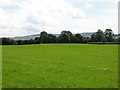
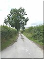
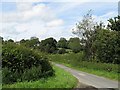
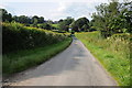
Anne T visited on 14th Jul 2021 - their rating: Cond: 2 Amb: 3 Access: 4 Crossfield Lane Barrow, near Kinnerton: as this was marked on the OS map, and on our way to Kinnerton, we quickly parked in the field entrance (which was put to pasture) and walked a little way along the edge of the field to take a closer look.
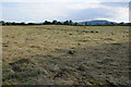
The barrow has been largely lost to ploughing, but a low, circular 'hump' in the field can be made out (easier to see with the naked eye rather than in a photograph).
 (PID:229899)")
This barrow is shown on the modern OS map, and recorded as Archwilio PRN 1078.
Largely now lost by ploughing, the barrow can more easily be seen with the naked eye as a circular 'hump' in the field, with a diameter of just over 30m. It rises about 0.5m maximum from the surrounding field level.
We parked at SO 24404 62532, at the end of a small lane/the entrance to the field containing the barrow, and walked a little way along the edge of the field to try and take a closer look. A logical 'next visit' from the Four Stones site just to the south, on the way to Kinnerton, but not the most exciting site in the world!
You may be viewing yesterday's version of this page. To see the most up to date information please register for a free account.
Do not use the above information on other web sites or publications without permission of the contributor.
Nearby Images from Geograph Britain and Ireland:
©2007(licence)
©2012(licence)
©2021(licence)
©2007(licence)
©2012(licence)
The above images may not be of the site on this page, they are loaded from Geograph.
Please Submit an Image of this site or go out and take one for us!
Click here to see more info for this site
Nearby sites
Key: Red: member's photo, Blue: 3rd party photo, Yellow: other image, Green: no photo - please go there and take one, Grey: site destroyed
Download sites to:
KML (Google Earth)
GPX (GPS waypoints)
CSV (Garmin/Navman)
CSV (Excel)
To unlock full downloads you need to sign up as a Contributory Member. Otherwise downloads are limited to 50 sites.
Turn off the page maps and other distractions
Nearby sites listing. In the following links * = Image available
374m NNE 33° Kinnerton* Standing Stones (SO24566274)
1.4km SE 146° Upper Ninepence barrow and Neolithic enclosure Round Barrow(s) (SO251613)
1.5km S 170° Four Stones Barrow Cemetary* Barrow Cemetery (SO24596091)
1.6km SSE 159° The Hindwell Stone* Standing Stone (Menhir) (SO24916093)
1.6km S 171° Four Stones (Powys)* Stone Circle (SO24576080)
1.7km SSE 149° Hindwell Farm 2* Round Barrow(s) (SO25226091)
1.8km SSE 161° Hindwell Cursus* Cursus (SO24926074)
1.9km SE 134° Hindwell Ash* Round Barrow(s) (SO25706111)
1.9km S 175° Hindwell Cursus* Cursus (SO24496052)
2.0km SSE 147° Hindwell Enclosure* Timber Circle (SO2544560720)
2.1km SSE 150° Hindwell Farm 1* Round Barrow(s) (SO25376064)
2.2km ESE 119° Knobley Stone* Standing Stone (Menhir) (SO26296132)
2.4km SE 128° Hindwell Causewayed Enclosure* Causewayed Enclosure (SO26246092)
2.5km S 182° Harpton Round Barrows* Round Barrow(s) (SO24225998)
2.5km NE 44° Beggar's Bush Barrow* Round Barrow(s) (SO26096417)
2.5km S 174° Knapp Mount Barrow* Barrow Cemetery (SO2458659975)
2.6km ENE 62° Castle Ring (Powys)* Hillfort (SO26646360)
2.6km SSE 160° Walton Palisaded Enclosure* Timber Circle (SO25235996)
3.2km WNW 292° Bach Hill Barrows* Round Barrow(s) (SO21396365)
3.2km SE 144° Walton Cursus Cursus (SO26195978)
3.3km SE 139° Walton Green Cursus (SO26525989)
3.4km SSE 168° Old Radnor Church* Standing Stone (Menhir) (SO24995909)
3.5km SE 134° Walton Cursus Cursus (SO26826001)
3.7km W 280° Whinyard Rocks Barrows* Round Barrow(s) (SO207631)
3.8km W 272° Whimble Barrow* Round Barrow(s) (SO205626)
View more nearby sites and additional images


 We would like to know more about this location. Please feel free to add a brief description and any relevant information in your own language.
 Wir möchten mehr über diese Stätte erfahren. Bitte zögern Sie nicht, eine kurze Beschreibung und relevante Informationen in Deutsch hinzuzufügen.
 Nous aimerions en savoir encore un peu sur les lieux. S'il vous plaît n'hesitez pas à ajouter une courte description et tous les renseignements pertinents dans votre propre langue.
 Quisieramos informarnos un poco más de las lugares. No dude en añadir una breve descripción y otros datos relevantes en su propio idioma.