


<< Other Photo Pages >> Castle Mestag - Hillfort in Scotland in Caithness
Submitted by durhamnature on Sunday, 23 September 2012 Page Views: 4066
Iron Age and Later PrehistorySite Name: Castle Mestag Alternative Name: Mell Head FortCountry: Scotland
NOTE: This site is 5.445 km away from the location you searched for.
County: Caithness Type: Hillfort
Map Ref: ND33977633
Latitude: 58.669732N Longitude: 3.140137W
Condition:
| 5 | Perfect |
| 4 | Almost Perfect |
| 3 | Reasonable but with some damage |
| 2 | Ruined but still recognisable as an ancient site |
| 1 | Pretty much destroyed, possibly visible as crop marks |
| 0 | No data. |
| -1 | Completely destroyed |
| 5 | Superb |
| 4 | Good |
| 3 | Ordinary |
| 2 | Not Good |
| 1 | Awful |
| 0 | No data. |
| 5 | Can be driven to, probably with disabled access |
| 4 | Short walk on a footpath |
| 3 | Requiring a bit more of a walk |
| 2 | A long walk |
| 1 | In the middle of nowhere, a nightmare to find |
| 0 | No data. |
| 5 | co-ordinates taken by GPS or official recorded co-ordinates |
| 4 | co-ordinates scaled from a detailed map |
| 3 | co-ordinates scaled from a bad map |
| 2 | co-ordinates of the nearest village |
| 1 | co-ordinates of the nearest town |
| 0 | no data |
Internal Links:
External Links:
")
Canmore site 9371
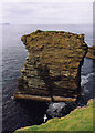
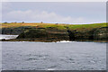
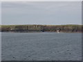
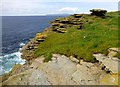
A fortified sea stack off the coast of Stroma, an island off the north coast of Scotland. The stack was once accessible by bridge, but is now inaccessible. There is no date for the fort.
You may be viewing yesterday's version of this page. To see the most up to date information please register for a free account.
")
Do not use the above information on other web sites or publications without permission of the contributor.
Nearby Images from Geograph Britain and Ireland:
©2008(licence)
©2021(licence)
©2008(licence)
©2015(licence)
©2008(licence)
The above images may not be of the site on this page, they are loaded from Geograph.
Please Submit an Image of this site or go out and take one for us!
Click here to see more info for this site
Nearby sites
Key: Red: member's photo, Blue: 3rd party photo, Yellow: other image, Green: no photo - please go there and take one, Grey: site destroyed
Download sites to:
KML (Google Earth)
GPX (GPS waypoints)
CSV (Garmin/Navman)
CSV (Excel)
To unlock full downloads you need to sign up as a Contributory Member. Otherwise downloads are limited to 50 sites.
Turn off the page maps and other distractions
Nearby sites listing. In the following links * = Image available
5.9km WSW 243° Cairn O'Mey Cairn (ND28657374)
6.5km S 189° Brabstermire Broch or Nuraghe (ND32856993)
7.3km SSE 153° Warth Hill* Stone Circle (ND37156979)
8.6km WSW 255° Scarfskerry Broch or Nuraghe (ND25647420)
9.0km WSW 253° Rattarburn Broch or Nuraghe (ND25257389)
9.4km SSE 156° Freswick Links* Broch or Nuraghe (ND37616761)
9.6km SE 145° Skirza Head Broch or Nuraghe (ND39406844)
10.1km SW 228° Earl's Cairn* Chambered Cairn (ND26296973)
12.7km N 358° Green Hill of Hestigeo Broch or Nuraghe (ND33758905)
12.8km NE 51° Ladykirk Stone* Rock Art (ND44008428)
12.8km N 1° Cantick Head Bowl Barrow Round Barrow(s) (ND34318915)
12.9km SSE 167° Caithness Broch Centre* Museum (ND367637)
12.9km SW 223° Ha' of Greenland Broch or Nuraghe (ND24906709)
12.9km SSE 166° Watenan Class I Pictish Symbol Stone (ND36806370)
13.2km N 0° Outer Green Hill Broch Chambered Cairn (ND34258958)
13.5km N 356° Burrowstone Broch or Nuraghe (ND333898)
13.5km SSE 166° Nybster Broch* Broch or Nuraghe (ND37026314)
13.5km WSW 239° Links of Dunnet Broch or Nuraghe (ND222696)
13.7km N 358° Green Hill of Scarton Broch or Nuraghe (ND33789005)
13.7km ENE 58° Banks Chambered Tomb* Chambered Cairn (ND45808339)
14.3km ENE 58° Tomb of the Eagles Museum Museum (ND4619783807)
14.6km SSW 199° Hill of Works* Broch or Nuraghe (ND29036255)
14.7km ENE 57° Isbister: Bronze Age House* Ancient Village or Settlement (ND46468411)
14.7km ENE 57° Liddel 2 Burnt Mound Ancient Village or Settlement (ND46498416)
14.8km S 176° Kirk Tofts* Broch or Nuraghe (ND34886151)
View more nearby sites and additional images


 We would like to know more about this location. Please feel free to add a brief description and any relevant information in your own language.
 Wir möchten mehr über diese Stätte erfahren. Bitte zögern Sie nicht, eine kurze Beschreibung und relevante Informationen in Deutsch hinzuzufügen.
 Nous aimerions en savoir encore un peu sur les lieux. S'il vous plaît n'hesitez pas à ajouter une courte description et tous les renseignements pertinents dans votre propre langue.
 Quisieramos informarnos un poco más de las lugares. No dude en añadir una breve descripción y otros datos relevantes en su propio idioma.