


<< Our Photo Pages >> Hoad Hill - Cairn in England in Cumbria
Submitted by Alphasmam on Thursday, 20 November 2014 Page Views: 2788
Neolithic and Bronze AgeSite Name: Hoad Hill Alternative Name: Sir John Barrow Monument on HoadCountry: England County: Cumbria Type: Cairn
Nearest Town: Ulverston
Map Ref: SD294790
Latitude: 54.201867N Longitude: 3.083777W
Condition:
| 5 | Perfect |
| 4 | Almost Perfect |
| 3 | Reasonable but with some damage |
| 2 | Ruined but still recognisable as an ancient site |
| 1 | Pretty much destroyed, possibly visible as crop marks |
| 0 | No data. |
| -1 | Completely destroyed |
| 5 | Superb |
| 4 | Good |
| 3 | Ordinary |
| 2 | Not Good |
| 1 | Awful |
| 0 | No data. |
| 5 | Can be driven to, probably with disabled access |
| 4 | Short walk on a footpath |
| 3 | Requiring a bit more of a walk |
| 2 | A long walk |
| 1 | In the middle of nowhere, a nightmare to find |
| 0 | No data. |
| 5 | co-ordinates taken by GPS or official recorded co-ordinates |
| 4 | co-ordinates scaled from a detailed map |
| 3 | co-ordinates scaled from a bad map |
| 2 | co-ordinates of the nearest village |
| 1 | co-ordinates of the nearest town |
| 0 | no data |
Internal Links:
External Links:
")
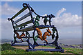
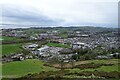
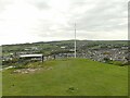
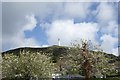
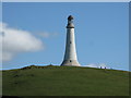
The Hoad Monument to Sir John Barrow is the most famous landmark in Ulverston.It was erected in 1850 and commemorates the life of Sir John Barrow who was an explorer and founder member of the Royal Geographical Society. It is a replica of the Eddystone Lighthouse. The path to it is very steep but easy to find and on the flanks of Hoad Hill we found a few remnants of what looked like cairns with some kerb stones visible in the grass.
I thought it was an obvious place for them as it is in line of sight of Birkrigg where the stone circle and evidence of cairns and enclosures can be seen. I think it is also possible that there was another cairn where the monument sits at the highest point. The construction and later refurbishment of the monument has seriously damaged any clear features.
It is a good walk and the views across Morecambe Bay and beyond are really good but if someone was an ardent cairn hunter they would be disappointed.
I've registered this site as evidence of ancient activity but not worth a special visit unless your aim is a good walk and a splendid view.
You may be viewing yesterday's version of this page. To see the most up to date information please register for a free account.
")
")
")
")
Do not use the above information on other web sites or publications without permission of the contributor.
Nearby Images from Geograph Britain and Ireland:
©2010(licence)
©2024(licence)
©2020(licence)
©2018(licence)
©2018(licence)
The above images may not be of the site on this page, they are loaded from Geograph.
Please Submit an Image of this site or go out and take one for us!
Click here to see more info for this site
Nearby sites
Key: Red: member's photo, Blue: 3rd party photo, Yellow: other image, Green: no photo - please go there and take one, Grey: site destroyed
Download sites to:
KML (Google Earth)
GPX (GPS waypoints)
CSV (Garmin/Navman)
CSV (Excel)
To unlock full downloads you need to sign up as a Contributory Member. Otherwise downloads are limited to 50 sites.
Turn off the page maps and other distractions
Nearby sites listing. In the following links * = Image available
3.8km NNE 33° Sheriff's Well (Greenodd) Holy Well or Sacred Spring (SD3150082130)
4.1km SSW 208° Great Urswick Long Barrow* Long Barrow (SD27427540)
4.3km NNE 27° Greenodd Holy Well (Egton with Newland) Holy Well or Sacred Spring (SD3144082770)
4.4km SSW 206° Great Urswick Fort* Hillfort (SD274751)
4.4km S 187° Birkrigg Common Round Cairn 3 Round Cairn (SD288746)
4.5km S 186° Birkrigg Common Settlement* Ancient Village or Settlement (SD28837453)
4.5km S 187° Birkrigg Common Enclosures and Appleby Hill and Stone Circle Ancient Village or Settlement (SD288745)
4.7km S 190° Birkrigg Common Round Cairn 1 Round Cairn (SD285744)
4.7km S 185° Birkrigg Common Round Cairn 2 Round Cairn (SD289743)
4.8km S 188° Birkrigg Common Cemetery* Barrow Cemetery (SD28627421)
5.0km S 181° Druids Temple (Cumbria)* Stone Circle (SD29237396)
5.1km SSW 193° Birkrigg Common Platform Cairn* Cairn (SD282740)
5.4km SSW 207° Great Urswick Cross* Ancient Cross (SD26867422)
5.4km NNW 344° The Beacon (Cumbria)* Stone Circle (SD28008423)
5.5km NNW 343° Lowick Ring Cairn (SD279843)
5.5km SSW 208° The Priapus Stone* Standing Stone (Menhir) (SD26757415)
5.5km SSW 213° Great Urswick Burial Chamber* Burial Chamber or Dolmen (SD26277442)
5.6km SW 223° Lindal Standing Stone* Standing Stone (Menhir) (SD255749)
5.7km NW 310° The Kirk Ring Cairn* Stone Circle (SD2507082693)
5.7km NW 310° The Kirk Stone Row* Multiple Stone Rows / Avenue (SD2509182770)
5.8km NW 312° Kirkby Moor Ringcairn* Round Cairn (SD25148299)
6.0km SW 214° Urswick Stone Walls* Ancient Village or Settlement (SD260741)
6.7km ESE 103° Holker Labyrinth and Standing Stones Modern Stone Circle etc (SD3590677373)
7.2km NNW 335° Great Burney* Ring Cairn (SD2640185541)
7.3km NNW 335° Great Burney* Cairn (SD26458565)
View more nearby sites and additional images


 We would like to know more about this location. Please feel free to add a brief description and any relevant information in your own language.
 Wir möchten mehr über diese Stätte erfahren. Bitte zögern Sie nicht, eine kurze Beschreibung und relevante Informationen in Deutsch hinzuzufügen.
 Nous aimerions en savoir encore un peu sur les lieux. S'il vous plaît n'hesitez pas à ajouter une courte description et tous les renseignements pertinents dans votre propre langue.
 Quisieramos informarnos un poco más de las lugares. No dude en añadir una breve descripción y otros datos relevantes en su propio idioma.