


<< Our Photo Pages >> Fontaine Saint-Gildas - Holy Well or Sacred Spring in France in Bretagne:Morbihan (56)
Submitted by ogham on Wednesday, 06 November 2013 Page Views: 1923
Springs and Holy WellsSite Name: Fontaine Saint-GildasCountry: France
NOTE: This site is 3.74 km away from the location you searched for.
Département: Bretagne:Morbihan (56) Type: Holy Well or Sacred Spring
Nearest Town: Pontivy Nearest Village: Bieuzy
Latitude: 47.978583N Longitude: 3.048967W
Condition:
| 5 | Perfect |
| 4 | Almost Perfect |
| 3 | Reasonable but with some damage |
| 2 | Ruined but still recognisable as an ancient site |
| 1 | Pretty much destroyed, possibly visible as crop marks |
| 0 | No data. |
| -1 | Completely destroyed |
| 5 | Superb |
| 4 | Good |
| 3 | Ordinary |
| 2 | Not Good |
| 1 | Awful |
| 0 | No data. |
| 5 | Can be driven to, probably with disabled access |
| 4 | Short walk on a footpath |
| 3 | Requiring a bit more of a walk |
| 2 | A long walk |
| 1 | In the middle of nowhere, a nightmare to find |
| 0 | No data. |
| 5 | co-ordinates taken by GPS or official recorded co-ordinates |
| 4 | co-ordinates scaled from a detailed map |
| 3 | co-ordinates scaled from a bad map |
| 2 | co-ordinates of the nearest village |
| 1 | co-ordinates of the nearest town |
| 0 | no data |
Internal Links:
External Links:
I have visited· I would like to visit
Ogham has visited here
")
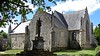
The fountain runs under the chapel. The latter is built on the side of a rock in front of the cave regarded as the hermitage of St. Gildas in the sixth century.
You may be viewing yesterday's version of this page. To see the most up to date information please register for a free account.
")
")
")
Do not use the above information on other web sites or publications without permission of the contributor.
Nearby Images from Flickr
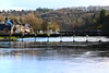


The above images may not be of the site on this page, but were taken nearby. They are loaded from Flickr so please click on them for image credits.
Click here to see more info for this site
Nearby sites
Click here to view sites on an interactive map of the areaKey: Red: member's photo, Blue: 3rd party photo, Yellow: other image, Green: no photo - please go there and take one, Grey: site destroyed
Download sites to:
KML (Google Earth)
GPX (GPS waypoints)
CSV (Garmin/Navman)
CSV (Excel)
To unlock full downloads you need to sign up as a Contributory Member. Otherwise downloads are limited to 50 sites.
Turn off the page maps and other distractions
Nearby sites listing. In the following links * = Image available
2.0km N 8° Kermabon Dolmen* Burial Chamber or Dolmen
6.1km NE 44° Menhir de Kerhoret* Standing Stone (Menhir)
6.3km NE 39° Kerhoret menhirs* Standing Stones
7.5km NW 313° Pierres de Kerlen* Standing Stones
7.6km SSW 192° Kernars menhirs* Standing Stones
7.8km S 183° Roffol menhir Standing Stone (Menhir)
8.4km NW 310° Menhir dit Men Glass Standing Stone (Menhir)
9.1km W 271° Menhir de Plomedec* Standing Stone (Menhir)
9.1km SW 222° Kroez-er-Voten tumulus* Chambered Tomb
9.7km SE 138° Mane Guen Pierre de Sacrifice* Rock Art
9.9km NNW 330° Menhir dit la Pierre du Diable (Guern) Standing Stone (Menhir)
11.0km NNW 338° Les Trois Menhirs de Saint-Etienne* Standing Stones
11.1km NNE 33° Sépulture circulaire de Pontivy* Cairn
11.2km NE 39° Menhir de la Chapelle de la Houssaie* Standing Stone (Menhir)
11.3km NNW 345° Saint Nizon allée couverte* Burial Chamber or Dolmen
11.5km S 169° Dolmen de Kerlatu Burial Chamber or Dolmen
12.3km NNE 18° Fontaine Ste-Meriadoc (Stival) Holy Well or Sacred Spring
12.5km SSW 191° Allée Couverte de Rohlas Passage Grave
12.5km SSW 206° Menhir de Kerdoret* Standing Stone (Menhir)
12.6km SSW 196° Allée Couverte de Kerscoul Passage Grave
13.4km SSW 206° Menhir de Kerdanué* Standing Stone (Menhir)
13.8km S 189° Petit-Resto menhir* Standing Stone (Menhir)
14.1km SSW 201° Menhir de Kerzerho Standing Stone (Menhir)
14.2km SSW 202° Menhir de Kerhel Standing Stone (Menhir)
14.5km S 178° Roh-Prioldi Allée Couverte* Passage Grave
View more nearby sites and additional images


 We would like to know more about this location. Please feel free to add a brief description and any relevant information in your own language.
 Wir möchten mehr über diese Stätte erfahren. Bitte zögern Sie nicht, eine kurze Beschreibung und relevante Informationen in Deutsch hinzuzufügen.
 Nous aimerions en savoir encore un peu sur les lieux. S'il vous plaît n'hesitez pas à ajouter une courte description et tous les renseignements pertinents dans votre propre langue.
 Quisieramos informarnos un poco más de las lugares. No dude en añadir una breve descripción y otros datos relevantes en su propio idioma.