 with our Megalithic Portal iPhone app")


<< Our Photo Pages >> Dunmail Raise - Round Cairn in England in Cumbria
Submitted by Adamibbo789 on Saturday, 01 February 2020 Page Views: 2326
Neolithic and Bronze AgeSite Name: Dunmail RaiseCountry: England County: Cumbria Type: Round Cairn
Nearest Town: Ambleside Nearest Village: Grasmere
Map Ref: NY32721170
Latitude: 54.496145N Longitude: 3.040289W
Condition:
| 5 | Perfect |
| 4 | Almost Perfect |
| 3 | Reasonable but with some damage |
| 2 | Ruined but still recognisable as an ancient site |
| 1 | Pretty much destroyed, possibly visible as crop marks |
| 0 | No data. |
| -1 | Completely destroyed |
| 5 | Superb |
| 4 | Good |
| 3 | Ordinary |
| 2 | Not Good |
| 1 | Awful |
| 0 | No data. |
| 5 | Can be driven to, probably with disabled access |
| 4 | Short walk on a footpath |
| 3 | Requiring a bit more of a walk |
| 2 | A long walk |
| 1 | In the middle of nowhere, a nightmare to find |
| 0 | No data. |
| 5 | co-ordinates taken by GPS or official recorded co-ordinates |
| 4 | co-ordinates scaled from a detailed map |
| 3 | co-ordinates scaled from a bad map |
| 2 | co-ordinates of the nearest village |
| 1 | co-ordinates of the nearest town |
| 0 | no data |
Internal Links:
External Links:
")
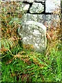
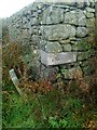
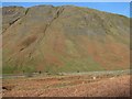
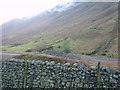
A Bronze Age Round Cairn found in the central reservation between Steel Fell and Helvellyn.
Pastscape description: "A Bronze Age round cairn built of stones on a stone-built platform measuring up to 18.5 metres in diameter. Local legend describes the cairn as representing the grave of Dunmail, the last king of Cumbria in the Early Medieval period. 19th century road workings heavily disturbed the cairn, however it has since been restored to what is thought to be its original form and position."
You may be viewing yesterday's version of this page. To see the most up to date information please register for a free account.
")
")
")
Do not use the above information on other web sites or publications without permission of the contributor.
Nearby Images from Geograph Britain and Ireland:
©2019(licence)
©2019(licence)
©2008(licence)
©2009(licence)
©2008(licence)
The above images may not be of the site on this page, they are loaded from Geograph.
Please Submit an Image of this site or go out and take one for us!
Click here to see more info for this site
Nearby sites
Key: Red: member's photo, Blue: 3rd party photo, Yellow: other image, Green: no photo - please go there and take one, Grey: site destroyed
Download sites to:
KML (Google Earth)
GPX (GPS waypoints)
CSV (Garmin/Navman)
CSV (Excel)
To unlock full downloads you need to sign up as a Contributory Member. Otherwise downloads are limited to 50 sites.
Turn off the page maps and other distractions
Nearby sites listing. In the following links * = Image available
2.1km SSE 148° Mêni Arthur Natural Stone / Erratic / Other Natural Feature (NY338099)
2.9km SW 230° Grasmere - Far Easedale* Natural Stone / Erratic / Other Natural Feature (NY305099)
4.1km SSE 163° Grasmere Cup-Marked Rocks* Rock Art (NY33850778)
4.2km S 170° Allan Bank Cup Marked Stone* Rock Art (NY334076)
5.3km N 352° Brown How Ring Cairn* Ring Cairn (NY3208017008)
6.0km SSW 192° Copt Howe* Rock Art (NY31400583)
7.0km SW 229° Langdale Axe Factory* Ancient Mine, Quarry or other Industry (NY274072)
7.0km SE 142° Rydal Hall Cup Marks Rock Art (NY369061)
7.1km E 90° Dovedale enclosure* Ancient Village or Settlement (NY398116)
7.3km SSW 213° Great Langdale* Rock Art (NY28650560)
7.6km NNW 338° Shoulthwaite Hillfort* Hillfort (NY300188)
7.8km NW 317° Reecastle Crag* Hillfort (NY275175)
7.8km NE 50° St Patrick's Well (Patterdale)* Holy Well or Sacred Spring (NY388166)
8.0km S 186° Little Langdale Cup-Marked Stone* Rock Art (NY317038)
8.1km ESE 112° The Kirkstone* Natural Stone / Erratic / Other Natural Feature (NY402086)
8.2km ENE 66° Beckstones* Rock Art (NY403150)
8.3km ENE 66° Beckstones Rock Art Ring Cairn (NY404150)
8.4km SE 144° The Armitt* Museum (NY376048)
8.6km WNW 302° Bowder Stone* Natural Stone / Erratic / Other Natural Feature (NY255164)
8.7km WNW 302° Pocklington's Druid Stone* Modern Stone Circle etc (NY2539116369)
8.9km WNW 297° Castle Crag Hillfort* Hillfort (NY249159)
8.9km SSW 199° Castle Howe (Little Langdale)* Hillfort (NY29730328)
9.0km W 270° Cappel-Crag/Seathwaite wall structure Misc. Earthwork (NY237119)
9.2km W 274° Borrowdale Stone Monument* Standing Stones (NY235125)
9.5km SSE 151° Ambleside Roman Fort* Ancient Village or Settlement (NY37260339)
View more nearby sites and additional images


 We would like to know more about this location. Please feel free to add a brief description and any relevant information in your own language.
 Wir möchten mehr über diese Stätte erfahren. Bitte zögern Sie nicht, eine kurze Beschreibung und relevante Informationen in Deutsch hinzuzufügen.
 Nous aimerions en savoir encore un peu sur les lieux. S'il vous plaît n'hesitez pas à ajouter une courte description et tous les renseignements pertinents dans votre propre langue.
 Quisieramos informarnos un poco más de las lugares. No dude en añadir una breve descripción y otros datos relevantes en su propio idioma.