


<< Other Photo Pages >> Bidston Hill Rock Carvings - Carving in England in Merseyside
Submitted by Sunny100 on Thursday, 13 March 2014 Page Views: 24308
Multi-periodSite Name: Bidston Hill Rock Carvings Alternative Name: The Bidston Sun GoddessCountry: England County: Merseyside Type: Carving
Nearest Town: Birkenhead Nearest Village: Bidston
Map Ref: SJ288900
Latitude: 53.402000N Longitude: 3.072364W
Condition:
| 5 | Perfect |
| 4 | Almost Perfect |
| 3 | Reasonable but with some damage |
| 2 | Ruined but still recognisable as an ancient site |
| 1 | Pretty much destroyed, possibly visible as crop marks |
| 0 | No data. |
| -1 | Completely destroyed |
| 5 | Superb |
| 4 | Good |
| 3 | Ordinary |
| 2 | Not Good |
| 1 | Awful |
| 0 | No data. |
| 5 | Can be driven to, probably with disabled access |
| 4 | Short walk on a footpath |
| 3 | Requiring a bit more of a walk |
| 2 | A long walk |
| 1 | In the middle of nowhere, a nightmare to find |
| 0 | No data. |
| 5 | co-ordinates taken by GPS or official recorded co-ordinates |
| 4 | co-ordinates scaled from a detailed map |
| 3 | co-ordinates scaled from a bad map |
| 2 | co-ordinates of the nearest village |
| 1 | co-ordinates of the nearest town |
| 0 | no data |
Internal Links:
External Links:
I have visited· I would like to visit
MmeSinn Cymraes would like to visit
Hogeybare visited on 21st Oct 2016 - their rating: Cond: 4 Amb: 5 Access: 4 Two sets of carvings, one of Goddess and Horse near the mill circles to the southeren end of the raised heathland, and pointing goddess on the stone surface below the observatory steps.
")
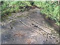
On a long flat sandstone outcrop just north east of the observatory is a four and half foot long carving of a sun goddess with outstretched arms. The head of the goddess faces the direction to where the sun sets on Midsummer's day. Also, there is a carving of a cat-headed Moon goddess with a moon at her feet. These carvings are thought to have been done by Viking settlers in the area - probably the 9th-10th century AD. However, one source put the age of the carvings as being Gallo-Roman from the 2nd century AD.
A short distance away another stone outcrop north of the observatory has the figure of a horses head carved onto it. On its neck there is a carved sun symbol. However, the age of this rock carving is uncertain -some historians think it could be more recent - perhaps the 18th century ? the sun symbol may be older. There is a stone with a hollow cut into it that collects rain water just beyond Bidston Hill; this however is again fairly recent - being used for the horrid sport of cock fighting.
Bidston Hill is associated with Arthurian legend. It is thought that Sir Gawain brought the Holy Grail with him when he travelled this way, and there are connections here with St Joseph of Arimathea, Jesus' uncle.
Note: Moon Goddess carving rediscovered by a local history group
You may be viewing yesterday's version of this page. To see the most up to date information please register for a free account.
")
Do not use the above information on other web sites or publications without permission of the contributor.
Nearby Images from Geograph Britain and Ireland:
©2007(licence)
©2007(licence)
©2013(licence)
©2014(licence)
©2007(licence)
The above images may not be of the site on this page, they are loaded from Geograph.
Please Submit an Image of this site or go out and take one for us!
Click here to see more info for this site
Nearby sites
Key: Red: member's photo, Blue: 3rd party photo, Yellow: other image, Green: no photo - please go there and take one, Grey: site destroyed
Download sites to:
KML (Google Earth)
GPX (GPS waypoints)
CSV (Garmin/Navman)
CSV (Excel)
To unlock full downloads you need to sign up as a Contributory Member. Otherwise downloads are limited to 50 sites.
Turn off the page maps and other distractions
Nearby sites listing. In the following links * = Image available
1.7km ESE 120° The Bonks Barrow Cemetery (SJ303891)
2.7km WSW 243° Overchurch* Stone Circle (SJ264888)
4.4km SSW 203° Arrowe Park standing stones Standing Stones (SJ27058596)
4.5km SW 221° Greasby Copse Ancient Village or Settlement (SJ25788664)
5.7km W 275° Great Meols* Ancient Village or Settlement (SJ231906)
6.0km E 82° World Museum Liverpool* Museum (SJ348908)
6.7km SW 220° Thor's Stone* Natural Stone / Erratic / Other Natural Feature (SJ2447484933)
7.4km SW 230° Face Stone (Stapledon Wood)* Rock Outcrop (SJ23088536)
7.4km WSW 243° West Kirby Cremation Burial Cist (SJ22158678)
7.4km WSW 242° The Column* Chambered Tomb (SJ222866)
7.8km WSW 242° St Bridget (West Kirby)* Early Christian Sculptured Stone (SJ21828641)
8.5km NE 55° St Mary (Walton on the Hill) Ancient Cross (SJ35889482)
8.6km WSW 259° Red Rocks Ancient Mine, Quarry or other Industry (SJ20328843)
9.1km SE 140° St Patrick's Well (Bromborough)* Holy Well or Sacred Spring (SJ34538295)
9.1km ENE 61° Modern stone circle on Cherry Avenue* Modern Stone Circle etc (SJ3687894265)
9.9km SE 141° St Barnabas (Bromborough)* Ancient Cross (SJ3491082212)
10.5km E 91° Monk's Well (Wavertree)* Holy Well or Sacred Spring (SJ39288959)
10.5km WSW 258° Hilbre Island (Wirral Peninsula) Ancient Cross (SJ185879)
10.8km ESE 108° Solomon's Tomb Modern Stone Circle etc (SJ391865)
11.6km SSE 161° Raby Mound Round Barrow(s) (SJ32377891)
11.7km ESE 107° Robin Hood's Stone* Standing Stone (Menhir) (SJ3997886383)
11.8km E 101° The Calderstones* Chambered Tomb (SJ4040287622)
12.5km S 178° St Mary and St Helen (Neston)* Ancient Cross (SJ29157749)
13.1km NNE 30° St Helen's Well (Sefton) Holy Well or Sacred Spring (SD35450129)
14.1km NNE 25° Lunt Meadows* Ancient Village or Settlement (SD349027)
View more nearby sites and additional images


 We would like to know more about this location. Please feel free to add a brief description and any relevant information in your own language.
 Wir möchten mehr über diese Stätte erfahren. Bitte zögern Sie nicht, eine kurze Beschreibung und relevante Informationen in Deutsch hinzuzufügen.
 Nous aimerions en savoir encore un peu sur les lieux. S'il vous plaît n'hesitez pas à ajouter une courte description et tous les renseignements pertinents dans votre propre langue.
 Quisieramos informarnos un poco más de las lugares. No dude en añadir una breve descripción y otros datos relevantes en su propio idioma.