


<< Our Photo Pages >> Threlkeld Knott - Ancient Village or Settlement in England in Cumbria
Submitted by threlkeld on Wednesday, 10 September 2003 Page Views: 13237
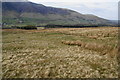
Multi-periodSite Name: Threlkeld KnottCountry: England County: Cumbria Type: Ancient Village or Settlement
Nearest Town: Keswick Nearest Village: Threlkeld
Map Ref: NY330241 Landranger Map Number: 90
Latitude: 54.607601N Longitude: 3.038795W
Condition:
| 5 | Perfect |
| 4 | Almost Perfect |
| 3 | Reasonable but with some damage |
| 2 | Ruined but still recognisable as an ancient site |
| 1 | Pretty much destroyed, possibly visible as crop marks |
| 0 | No data. |
| -1 | Completely destroyed |
| 5 | Superb |
| 4 | Good |
| 3 | Ordinary |
| 2 | Not Good |
| 1 | Awful |
| 0 | No data. |
| 5 | Can be driven to, probably with disabled access |
| 4 | Short walk on a footpath |
| 3 | Requiring a bit more of a walk |
| 2 | A long walk |
| 1 | In the middle of nowhere, a nightmare to find |
| 0 | No data. |
| 5 | co-ordinates taken by GPS or official recorded co-ordinates |
| 4 | co-ordinates scaled from a detailed map |
| 3 | co-ordinates scaled from a bad map |
| 2 | co-ordinates of the nearest village |
| 1 | co-ordinates of the nearest town |
| 0 | no data |
Internal Links:
External Links:
I have visited· I would like to visit
heidavey has visited here
")
Have you visited this site? Please add a comment below.
You may be viewing yesterday's version of this page. To see the most up to date information please register for a free account.
")
")
")
Do not use the above information on other web sites or publications without permission of the contributor.
Nearby Images from Geograph Britain and Ireland:
©2010(licence)
©2011(licence)
©2015(licence)
©2022(licence)
©2015(licence)
The above images may not be of the site on this page, they are loaded from Geograph.
Please Submit an Image of this site or go out and take one for us!
Click here to see more info for this site
Nearby sites
Key: Red: member's photo, Blue: 3rd party photo, Yellow: other image, Green: no photo - please go there and take one, Grey: site destroyed
Download sites to:
KML (Google Earth)
GPX (GPS waypoints)
CSV (Garmin/Navman)
CSV (Excel)
To unlock full downloads you need to sign up as a Contributory Member. Otherwise downloads are limited to 50 sites.
Turn off the page maps and other distractions
Nearby sites listing. In the following links * = Image available
2.9km SW 234° Holy Well of St John the Baptist* Holy Well or Sacred Spring (NY30622245)
3.9km W 262° Castlerigg* Stone Circle (NY29132363)
4.0km W 262° Castlerigg W* Stone Circle (NY29062360)
6.1km SSW 209° Shoulthwaite Hillfort* Hillfort (NY300188)
6.7km WSW 246° Millennium Stone, Derwent Water* Modern Stone Circle etc (NY268215)
6.8km ENE 78° Great Mell Fell Tumulus* Round Cairn (NY3967825366)
7.1km S 187° Brown How Ring Cairn* Ring Cairn (NY3208017008)
8.6km SW 219° Reecastle Crag* Hillfort (NY275175)
9.5km SE 142° St Patrick's Well (Patterdale)* Holy Well or Sacred Spring (NY388166)
9.6km N 6° Carrock Fell* Hillfort (NY342336)
9.6km N 2° Round Knott Cairn (NY334337)
9.6km SW 233° Salt Well (Grange)* Holy Well or Sacred Spring (NY25161848)
9.8km ENE 64° Motherby Stone Circle (NY419282)
9.8km ENE 64° Penruddock Stone Circle (NY419282)
9.9km NNE 13° Mungrisedale* Cairn (NY353337)
10.7km ENE 67° Motherby (Cumbria)* Holy Well or Sacred Spring (NY4293428212)
10.7km SW 223° Bowder Stone* Natural Stone / Erratic / Other Natural Feature (NY255164)
10.8km SW 224° Pocklington's Druid Stone* Modern Stone Circle etc (NY2539116369)
11.2km NE 49° Berrier Hill Earthworks Misc. Earthwork (NY416313)
11.4km ESE 113° Hallin Fell* Cairn (NY435195)
11.5km SW 224° Castle Crag Hillfort* Hillfort (NY249159)
11.6km SE 140° Beckstones* Rock Art (NY403150)
11.7km SE 140° Beckstones Rock Art Ring Cairn (NY404150)
11.9km ESE 118° St Martin’s Church (Martindale)* Sculptured Stone (NY43431840)
12.1km E 88° Maiden Castle (Cumbria) Hillfort (NY451243)
View more nearby sites and additional images


 We would like to know more about this location. Please feel free to add a brief description and any relevant information in your own language.
 Wir möchten mehr über diese Stätte erfahren. Bitte zögern Sie nicht, eine kurze Beschreibung und relevante Informationen in Deutsch hinzuzufügen.
 Nous aimerions en savoir encore un peu sur les lieux. S'il vous plaît n'hesitez pas à ajouter une courte description et tous les renseignements pertinents dans votre propre langue.
 Quisieramos informarnos un poco más de las lugares. No dude en añadir una breve descripción y otros datos relevantes en su propio idioma.