


<< Our Photo Pages >> Balkello Standing Stone - Standing Stone (Menhir) in Scotland in Angus
Submitted by stuant63 on Saturday, 23 January 2021 Page Views: 732
Neolithic and Bronze AgeSite Name: Balkello Standing Stone Alternative Name: Standing Stone Of BalkelloCountry: Scotland
NOTE: This site is 0.422 km away from the location you searched for.
County: Angus Type: Standing Stone (Menhir)
Nearest Town: Kirkton of Auchterhouse Nearest Village: North Balkello
Map Ref: NO36333830
Latitude: 56.532386N Longitude: 3.03675W
Condition:
| 5 | Perfect |
| 4 | Almost Perfect |
| 3 | Reasonable but with some damage |
| 2 | Ruined but still recognisable as an ancient site |
| 1 | Pretty much destroyed, possibly visible as crop marks |
| 0 | No data. |
| -1 | Completely destroyed |
| 5 | Superb |
| 4 | Good |
| 3 | Ordinary |
| 2 | Not Good |
| 1 | Awful |
| 0 | No data. |
| 5 | Can be driven to, probably with disabled access |
| 4 | Short walk on a footpath |
| 3 | Requiring a bit more of a walk |
| 2 | A long walk |
| 1 | In the middle of nowhere, a nightmare to find |
| 0 | No data. |
| 5 | co-ordinates taken by GPS or official recorded co-ordinates |
| 4 | co-ordinates scaled from a detailed map |
| 3 | co-ordinates scaled from a bad map |
| 2 | co-ordinates of the nearest village |
| 1 | co-ordinates of the nearest town |
| 0 | no data |
Internal Links:
External Links:
")
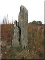
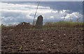
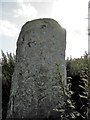
A 2.7 metre high standing stone. Unmarked. Weathered and splitting.
Situated 150m west of The Old Schoolhouse of North Balkello.
A jumble of stones lies at the foot of the stone on the South side but this may be simply from field clearance work.
This stone is mentioned in the Name Book 1860.
You may be viewing yesterday's version of this page. To see the most up to date information please register for a free account.
")
")
")
Do not use the above information on other web sites or publications without permission of the contributor.
Nearby Images from Geograph Britain and Ireland:
©2008(licence)
©2014(licence)
©2016(licence)
©2016(licence)
©2011(licence)
The above images may not be of the site on this page, they are loaded from Geograph.
Please Submit an Image of this site or go out and take one for us!
Click here to see more info for this site
Nearby sites
Key: Red: member's photo, Blue: 3rd party photo, Yellow: other image, Green: no photo - please go there and take one, Grey: site destroyed
Download sites to:
KML (Google Earth)
GPX (GPS waypoints)
CSV (Garmin/Navman)
CSV (Excel)
To unlock full downloads you need to sign up as a Contributory Member. Otherwise downloads are limited to 50 sites.
Turn off the page maps and other distractions
Nearby sites listing. In the following links * = Image available
1.4km ESE 121° Balluderon* Class II Pictish Symbol Stone (NO37483758)
1.9km E 86° Balkemback* Stone Circle (NO382384)
2.0km WNW 299° Witches Stone (Auchterhouse) Stone Circle (NO34603928)
2.0km WNW 295° Auchterhouse Standing Stones (NO345392)
2.4km SSW 199° Templelands (Auchterhouse) Stone Circle (NO355360)
3.0km ENE 63° Prieston* Rock Art (NO39023960)
3.4km NE 52° Gallow Hill A* Rock Art (NO39054033)
3.4km SSE 154° Strathmartine 3 Class II Pictish Symbol Stone (NO378352)
4.0km NE 53° Gallow Hill B* Rock Art (NO39584066)
4.9km E 91° Tealing* Souterrain (Fogou, Earth House) (NO412381)
5.2km ENE 73° Huntingfaulds* Rock Art (NO41303974)
5.3km SSW 213° Liff and Benvie Cursus Cursus (NO33403391)
5.3km SW 214° Liff and Benvie Cursus Cursus (NO33263396)
5.5km S 188° Camperdown Standing Stone* Standing Stone (Menhir) (NO3549632905)
5.5km ENE 74° Tealing Stones* Standing Stones (NO4165139785)
6.3km SSW 209° Hurly Hawkins* Broch or Nuraghe (NO332328)
6.8km S 188° Balgarthno* Stone Circle (NO35333161)
7.3km S 180° Dark Stane Roundie* Round Barrow(s) (NO362310)
7.5km SSW 193° Devil's Stone (Perth & Kinross)* Standing Stone (Menhir) (NO3458131019)
7.7km SSW 196° Longforgan Cursus Cursus (NO34163094)
7.7km SSW 196° Longforgan Cursus Cursus (NO34123090)
8.4km S 190° St Peter's Church (Invergowrie)* Early Christian Sculptured Stone (NO348300)
8.6km WNW 285° Kinpurnie Castle (Newtyle) Cairn (NO2807740693)
8.7km SSW 199° Mylnefield Stone Circle (NO334301)
8.7km SSE 153° McManus Galleries* Museum (NO40253047)
View more nearby sites and additional images


 We would like to know more about this location. Please feel free to add a brief description and any relevant information in your own language.
 Wir möchten mehr über diese Stätte erfahren. Bitte zögern Sie nicht, eine kurze Beschreibung und relevante Informationen in Deutsch hinzuzufügen.
 Nous aimerions en savoir encore un peu sur les lieux. S'il vous plaît n'hesitez pas à ajouter une courte description et tous les renseignements pertinents dans votre propre langue.
 Quisieramos informarnos un poco más de las lugares. No dude en añadir una breve descripción y otros datos relevantes en su propio idioma.