


<< Our Photo Pages >> Brown How Ring Cairn - Ring Cairn in England in Cumbria
Submitted by Meaty_Mungus on Thursday, 10 January 2019 Page Views: 2228
Neolithic and Bronze AgeSite Name: Brown How Ring CairnCountry: England County: Cumbria Type: Ring Cairn
Nearest Village: Thirlmere
Map Ref: NY3208017008
Latitude: 54.543754N Longitude: 3.051393W
Condition:
| 5 | Perfect |
| 4 | Almost Perfect |
| 3 | Reasonable but with some damage |
| 2 | Ruined but still recognisable as an ancient site |
| 1 | Pretty much destroyed, possibly visible as crop marks |
| 0 | No data. |
| -1 | Completely destroyed |
| 5 | Superb |
| 4 | Good |
| 3 | Ordinary |
| 2 | Not Good |
| 1 | Awful |
| 0 | No data. |
| 5 | Can be driven to, probably with disabled access |
| 4 | Short walk on a footpath |
| 3 | Requiring a bit more of a walk |
| 2 | A long walk |
| 1 | In the middle of nowhere, a nightmare to find |
| 0 | No data. |
| 5 | co-ordinates taken by GPS or official recorded co-ordinates |
| 4 | co-ordinates scaled from a detailed map |
| 3 | co-ordinates scaled from a bad map |
| 2 | co-ordinates of the nearest village |
| 1 | co-ordinates of the nearest town |
| 0 | no data |
Internal Links:
External Links:
")
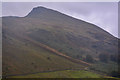
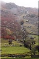
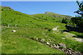
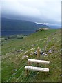
Ring Cairn with low stone wall perched on the hillside above craggy outcrops overlooking Thirlmere. The hill slopes down from Whiteside and Brown Crag with a slight depression and then there is a slightly raised grass topped outcrop before the hillside falls away steeply towards Thirlmere. This is off the normal beaten path and I just happened to notice it while out wandering.
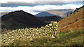
There is a pile of smaller rock with a large rock weighing at least a couple of tonnes perched on top of the small pile and this is surrounded by grass and on a raised area so couldn't possibly be a natural formation. See photos.
This site is perched between the summits of Helvellyn off to the South and Skiddaw off to the North. There is a commanding view up and down the Thirlmere valley and even Castlerigg off in the distance before Skiddaw. There is a small stone cairn, 30 metres(approx) to the North, made with half a dozen large rocks perched on a raised area which aligns between this site and Skiddaw.
This is a well hidden site and can't be seen until you are right next to it. It doesn't show on the satellite view.
You may be viewing yesterday's version of this page. To see the most up to date information please register for a free account.
")
")
")
Do not use the above information on other web sites or publications without permission of the contributor.
Nearby Images from Geograph Britain and Ireland:
©2020(licence)
©2009(licence)
©2010(licence)
©2017(licence)
©2013(licence)
The above images may not be of the site on this page, they are loaded from Geograph.
Please Submit an Image of this site or go out and take one for us!
Click here to see more info for this site
Nearby sites
Key: Red: member's photo, Blue: 3rd party photo, Yellow: other image, Green: no photo - please go there and take one, Grey: site destroyed
Download sites to:
KML (Google Earth)
GPX (GPS waypoints)
CSV (Garmin/Navman)
CSV (Excel)
To unlock full downloads you need to sign up as a Contributory Member. Otherwise downloads are limited to 50 sites.
Turn off the page maps and other distractions
Nearby sites listing. In the following links * = Image available
2.7km NW 310° Shoulthwaite Hillfort* Hillfort (NY300188)
4.6km W 275° Reecastle Crag* Hillfort (NY275175)
5.3km S 172° Dunmail Raise* Round Cairn (NY32721170)
5.6km NNW 344° Holy Well of St John the Baptist* Holy Well or Sacred Spring (NY30622245)
6.6km W 264° Bowder Stone* Natural Stone / Erratic / Other Natural Feature (NY255164)
6.7km W 264° Pocklington's Druid Stone* Modern Stone Circle etc (NY2539116369)
6.7km E 93° St Patrick's Well (Patterdale)* Holy Well or Sacred Spring (NY388166)
6.9km NW 310° Millennium Stone, Derwent Water* Modern Stone Circle etc (NY268215)
7.1km W 281° Salt Well (Grange)* Holy Well or Sacred Spring (NY25161848)
7.1km N 7° Threlkeld Knott* Ancient Village or Settlement (NY330241)
7.2km NNW 335° Castlerigg* Stone Circle (NY29132363)
7.2km NNW 335° Castlerigg W* Stone Circle (NY29062360)
7.2km W 260° Castle Crag Hillfort* Hillfort (NY249159)
7.3km SSW 192° Grasmere - Far Easedale* Natural Stone / Erratic / Other Natural Feature (NY305099)
7.3km SSE 166° Mêni Arthur Natural Stone / Erratic / Other Natural Feature (NY338099)
8.4km ESE 103° Beckstones* Rock Art (NY403150)
8.5km ESE 103° Beckstones Rock Art Ring Cairn (NY404150)
9.4km SSE 168° Grasmere Cup-Marked Rocks* Rock Art (NY33850778)
9.4km SE 124° Dovedale enclosure* Ancient Village or Settlement (NY398116)
9.5km S 171° Allan Bank Cup Marked Stone* Rock Art (NY334076)
9.7km WSW 241° Borrowdale Stone Monument* Standing Stones (NY235125)
9.8km WSW 238° Cappel-Crag/Seathwaite wall structure Misc. Earthwork (NY237119)
10.9km SSW 205° Langdale Axe Factory* Ancient Mine, Quarry or other Industry (NY274072)
11.2km S 183° Copt Howe* Rock Art (NY31400583)
11.3km NE 41° Great Mell Fell Tumulus* Round Cairn (NY3967825366)
View more nearby sites and additional images


 We would like to know more about this location. Please feel free to add a brief description and any relevant information in your own language.
 Wir möchten mehr über diese Stätte erfahren. Bitte zögern Sie nicht, eine kurze Beschreibung und relevante Informationen in Deutsch hinzuzufügen.
 Nous aimerions en savoir encore un peu sur les lieux. S'il vous plaît n'hesitez pas à ajouter une courte description et tous les renseignements pertinents dans votre propre langue.
 Quisieramos informarnos un poco más de las lugares. No dude en añadir una breve descripción y otros datos relevantes en su propio idioma.