


<< Our Photo Pages >> St Michael's Holy Well - Holy Well or Sacred Spring in England in Cumbria
Submitted by hoya105 on Saturday, 30 November 2019 Page Views: 2584
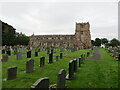
Springs and Holy WellsSite Name: St Michael's Holy Well Alternative Name: Arthuret wellCountry: England County: Cumbria Type: Holy Well or Sacred Spring
Nearest Town: Carlisle Nearest Village: Longtown
Map Ref: NY3789967755
Latitude: 55.000475N Longitude: 2.972337W
Condition:
| 5 | Perfect |
| 4 | Almost Perfect |
| 3 | Reasonable but with some damage |
| 2 | Ruined but still recognisable as an ancient site |
| 1 | Pretty much destroyed, possibly visible as crop marks |
| 0 | No data. |
| -1 | Completely destroyed |
| 5 | Superb |
| 4 | Good |
| 3 | Ordinary |
| 2 | Not Good |
| 1 | Awful |
| 0 | No data. |
| 5 | Can be driven to, probably with disabled access |
| 4 | Short walk on a footpath |
| 3 | Requiring a bit more of a walk |
| 2 | A long walk |
| 1 | In the middle of nowhere, a nightmare to find |
| 0 | No data. |
| 5 | co-ordinates taken by GPS or official recorded co-ordinates |
| 4 | co-ordinates scaled from a detailed map |
| 3 | co-ordinates scaled from a bad map |
| 2 | co-ordinates of the nearest village |
| 1 | co-ordinates of the nearest town |
| 0 | no data |
Internal Links:
External Links:
")
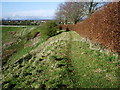
Lovely well set in the side of the bank behind the church of St Michael and All Angels. Recently cleared of foliage, with steps down to the water.
Park in spacious lay-by opposite church, walk past church, through a gate and along the bank. The well is below you.
Grade 2 listed.
For more information see both Pastscape Monument No. 10820 and Historic England List Entry No. 13356119ST MICHAEL'S WELL, NORTH WEST OF CHURCH OF ST MICHAEL).
You may be viewing yesterday's version of this page. To see the most up to date information please register for a free account.
")
")
")
Do not use the above information on other web sites or publications without permission of the contributor.
Nearby Images from Geograph Britain and Ireland:
©2010(licence)
©2016(licence)
©2020(licence)
©2010(licence)
©2021(licence)
The above images may not be of the site on this page, they are loaded from Geograph.
Please Submit an Image of this site or go out and take one for us!
Click here to see more info for this site
Nearby sites
Key: Red: member's photo, Blue: 3rd party photo, Yellow: other image, Green: no photo - please go there and take one, Grey: site destroyed
Download sites to:
KML (Google Earth)
GPX (GPS waypoints)
CSV (Garmin/Navman)
CSV (Excel)
To unlock full downloads you need to sign up as a Contributory Member. Otherwise downloads are limited to 50 sites.
Turn off the page maps and other distractions
Nearby sites listing. In the following links * = Image available
100m SSE 161° Arthuret Church cross* Ancient Cross (NY37936766)
4.2km NNE 23° Castra Exploratorum Ancient Village or Settlement (NY39607160)
4.4km NNE 15° St Andrew's Well (Kirkandrews-on-Esk) Holy Well or Sacred Spring (NY3913071970)
5.5km N 5° Scots' Dike* Misc. Earthwork (NY38507325)
6.0km W 272° Gretna Sculptured Stone (NY319680)
6.4km SSW 197° Rockcliffe (Cumbria)* Ancient Cross (NY35896162)
6.9km WSW 254° Lochmaben Stane* Standing Stone (Menhir) (NY3123665983)
8.7km SW 217° King Edward's Monument* Cairn (NY3257460920)
9.0km SSW 199° St Mary's Motte (Beaumont)* Misc. Earthwork (NY3480459296)
9.0km NW 317° Half Morton Cursus Cursus (NY31807440)
9.2km NW 317° Half Morton Cursus Cursus (NY31707459)
9.6km SSW 194° St Andrew's Well (Kirkandrews-on-Eden)* Holy Well or Sacred Spring (NY35395851)
9.9km W 278° Mossknowe 2* Cairn (NY2806469266)
10.0km W 277° Mossknowe 3* Cairn (NY2793169102)
10.2km W 279° Mossknowe Tumulus* Cairn (NY27836948)
10.6km S 181° Stainton West Ancient Mine, Quarry or other Industry (NY3759457137)
10.8km N 1° Gilnochie Tower rock art* Rock Art (NY3823178559)
10.9km SSE 166° Homeacres Holy Well (Stanwix)* Holy Well or Sacred Spring (NY40415709)
11.1km S 170° Hyssop Holme Well (Carlisle)* Holy Well or Sacred Spring (NY3974856801)
11.2km S 170° Roman Bridge Remains (Bitts Park)* Ancient Trackway (NY3961056670)
11.4km ESE 118° Chapel Well (Irthington) Holy Well or Sacred Spring (NY4791062345)
11.4km NE 47° Solport Holy Well (Catlowdy) Holy Well or Sacred Spring (NY4637075490)
11.6km NE 47° Holywell (Catlowdy)* Holy Well or Sacred Spring (NY4649175570)
11.8km S 170° Tullie House Museum* Museum (NY3978556106)
12.0km S 170° Carlisle Anglo Saxon Crosses* Ancient Cross (NY39885595)
View more nearby sites and additional images


 We would like to know more about this location. Please feel free to add a brief description and any relevant information in your own language.
 Wir möchten mehr über diese Stätte erfahren. Bitte zögern Sie nicht, eine kurze Beschreibung und relevante Informationen in Deutsch hinzuzufügen.
 Nous aimerions en savoir encore un peu sur les lieux. S'il vous plaît n'hesitez pas à ajouter une courte description et tous les renseignements pertinents dans votre propre langue.
 Quisieramos informarnos un poco más de las lugares. No dude en añadir una breve descripción y otros datos relevantes en su propio idioma.