


<< Text Pages >> St Mary (Walton on the Hill) - Ancient Cross in England in Merseyside
Submitted by TimPrevett on Saturday, 26 May 2007 Page Views: 7678
Early Medieval (Dark Age)Site Name: St Mary (Walton on the Hill)Country: England
NOTE: This site is 1.98 km away from the location you searched for.
County: Merseyside Type: Ancient Cross
Nearest Town: Liverpool
Map Ref: SJ35889482
Latitude: 53.446227N Longitude: 2.966876W
Condition:
| 5 | Perfect |
| 4 | Almost Perfect |
| 3 | Reasonable but with some damage |
| 2 | Ruined but still recognisable as an ancient site |
| 1 | Pretty much destroyed, possibly visible as crop marks |
| 0 | No data. |
| -1 | Completely destroyed |
| 5 | Superb |
| 4 | Good |
| 3 | Ordinary |
| 2 | Not Good |
| 1 | Awful |
| 0 | No data. |
| 5 | Can be driven to, probably with disabled access |
| 4 | Short walk on a footpath |
| 3 | Requiring a bit more of a walk |
| 2 | A long walk |
| 1 | In the middle of nowhere, a nightmare to find |
| 0 | No data. |
| 5 | co-ordinates taken by GPS or official recorded co-ordinates |
| 4 | co-ordinates scaled from a detailed map |
| 3 | co-ordinates scaled from a bad map |
| 2 | co-ordinates of the nearest village |
| 1 | co-ordinates of the nearest town |
| 0 | no data |
Be the first person to rate this site - see the 'Contribute!' box in the right hand menu.
Internal Links:
External Links:
Ancient Cross in Merseyside
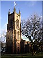
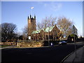
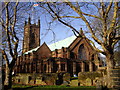
Late Anglo Saxon Cross base to the south of St Mary's, Walton on the Hill.
You may be viewing yesterday's version of this page. To see the most up to date information please register for a free account.
Do not use the above information on other web sites or publications without permission of the contributor.
Nearby Images from Geograph Britain and Ireland:
©2011(licence)
©2011(licence)
©2011(licence)

©2006(licence)

©2011(licence)
The above images may not be of the site on this page, they are loaded from Geograph.
Please Submit an Image of this site or go out and take one for us!
Click here to see more info for this site
Nearby sites
Key: Red: member's photo, Blue: 3rd party photo, Yellow: other image, Green: no photo - please go there and take one, Grey: site destroyed
Download sites to:
KML (Google Earth)
GPX (GPS waypoints)
CSV (Garmin/Navman)
CSV (Excel)
To unlock full downloads you need to sign up as a Contributory Member. Otherwise downloads are limited to 50 sites.
Turn off the page maps and other distractions
Nearby sites listing. In the following links * = Image available
1.1km ESE 118° Modern stone circle on Cherry Avenue* Modern Stone Circle etc (SJ3687894265)
4.2km SSW 194° World Museum Liverpool* Museum (SJ348908)
6.2km SSE 146° Monk's Well (Wavertree)* Holy Well or Sacred Spring (SJ39288959)
6.5km N 355° St Helen's Well (Sefton) Holy Well or Sacred Spring (SD35450129)
7.9km N 352° Lunt Meadows* Ancient Village or Settlement (SD349027)
8.0km SW 223° The Bonks Barrow Cemetery (SJ303891)
8.5km SSE 147° The Calderstones* Chambered Tomb (SJ4040287622)
8.5km SW 235° Bidston Hill Rock Carvings* Carving (SJ288900)
8.9km SSE 158° Solomon's Tomb Modern Stone Circle etc (SJ391865)
9.4km SSE 153° Robin Hood's Stone* Standing Stone (Menhir) (SJ3997886383)
11.1km SE 143° Camp Hill (Woolton) Hillfort (SJ424858)
11.2km WSW 237° Overchurch* Stone Circle (SJ264888)
11.9km S 186° St Patrick's Well (Bromborough)* Holy Well or Sacred Spring (SJ34538295)
12.5km SW 224° Arrowe Park standing stones Standing Stones (SJ27058596)
12.6km S 184° St Barnabas (Bromborough)* Ancient Cross (SJ3491082212)
13.0km SW 230° Greasby Copse Ancient Village or Settlement (SJ25788664)
13.4km WSW 251° Great Meols* Ancient Village or Settlement (SJ231906)
14.2km NW 326° The Godstone* Marker Stone (SD28070668)
14.4km ESE 103° St Anne's Well (St Helens)* Holy Well or Sacred Spring (SJ49969143)
14.6km NNE 21° Church of Saint Peter and Saint Paul* Carving (SD4130608436)
15.1km SW 228° Thor's Stone* Natural Stone / Erratic / Other Natural Feature (SJ2447484933)
15.6km NNW 327° Formby Point* Ancient Trackway (SD27500800)
15.9km WSW 239° West Kirby Cremation Burial Cist (SJ22158678)
15.9km SW 233° Face Stone (Stapledon Wood)* Rock Outcrop (SJ23088536)
15.9km WSW 238° The Column* Chambered Tomb (SJ222866)
View more nearby sites and additional images


 We would like to know more about this location. Please feel free to add a brief description and any relevant information in your own language.
 Wir möchten mehr über diese Stätte erfahren. Bitte zögern Sie nicht, eine kurze Beschreibung und relevante Informationen in Deutsch hinzuzufügen.
 Nous aimerions en savoir encore un peu sur les lieux. S'il vous plaît n'hesitez pas à ajouter une courte description et tous les renseignements pertinents dans votre propre langue.
 Quisieramos informarnos un poco más de las lugares. No dude en añadir una breve descripción y otros datos relevantes en su propio idioma.