


<< Our Photo Pages >> The Atropos Altar Stone - Sculptured Stone in Wales in Wrexham
Submitted by Sunny100 on Wednesday, 16 June 2010 Page Views: 8632
Multi-periodSite Name: The Atropos Altar Stone Alternative Name: The Nemesis Stone, The Gresford Altar Stone, All Saints Church (Gresford)Country: Wales
NOTE: This site is 1.319 km away from the location you searched for.
County: Wrexham Type: Sculptured Stone
Nearest Town: Gresford
Map Ref: SJ34645497
Latitude: 53.087925N Longitude: 2.977338W
Condition:
| 5 | Perfect |
| 4 | Almost Perfect |
| 3 | Reasonable but with some damage |
| 2 | Ruined but still recognisable as an ancient site |
| 1 | Pretty much destroyed, possibly visible as crop marks |
| 0 | No data. |
| -1 | Completely destroyed |
| 5 | Superb |
| 4 | Good |
| 3 | Ordinary |
| 2 | Not Good |
| 1 | Awful |
| 0 | No data. |
| 5 | Can be driven to, probably with disabled access |
| 4 | Short walk on a footpath |
| 3 | Requiring a bit more of a walk |
| 2 | A long walk |
| 1 | In the middle of nowhere, a nightmare to find |
| 0 | No data. |
| 5 | co-ordinates taken by GPS or official recorded co-ordinates |
| 4 | co-ordinates scaled from a detailed map |
| 3 | co-ordinates scaled from a bad map |
| 2 | co-ordinates of the nearest village |
| 1 | co-ordinates of the nearest town |
| 0 | no data |
Internal Links:
External Links:
I have visited· I would like to visit
elad13 would like to visit
")
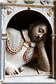
The figure on the stone has a pair of shears, something Atropos would have used. The church, however, might see that as a sign that this is a Christianised stone - shears representing Christ's crucifixion. It could also be part of a Romano-Celtic shrine from a slightly later date, the 4th or 5th century. The stone has four sides and at the top there is a depression for something to be placed.
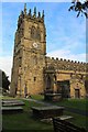
All Saints church is thought to stand on a roman/Saxon site. But the present church dates from between the 13th and 15th centuries. On the outer walls of the church there are some interesting carvings: a green man, a tiny demon and some cat-like creatures (or some other similar animals). They look quite frightening but they are there to ward off evil spirits.
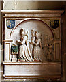
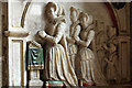
For more information see Coflein NPRN 165221, which has 143 digital images of the church and various stones in and around the church and says the church has "exceptional medieval furnishings".
You may be viewing yesterday's version of this page. To see the most up to date information please register for a free account.
")
")
")
")
Do not use the above information on other web sites or publications without permission of the contributor.
Nearby Images from Geograph Britain and Ireland:
©2014(licence)

©2014(licence)
©2018(licence)
©2014(licence)
©2014(licence)
The above images may not be of the site on this page, they are loaded from Geograph.
Please Submit an Image of this site or go out and take one for us!
Click here to see more info for this site
Nearby sites
Key: Red: member's photo, Blue: 3rd party photo, Yellow: other image, Green: no photo - please go there and take one, Grey: site destroyed
Download sites to:
KML (Google Earth)
GPX (GPS waypoints)
CSV (Garmin/Navman)
CSV (Excel)
To unlock full downloads you need to sign up as a Contributory Member. Otherwise downloads are limited to 50 sites.
Turn off the page maps and other distractions
Nearby sites listing. In the following links * = Image available
2.0km SW 229° Bryn Alyn* Hillfort (SJ33125370)
2.8km SSE 154° Borras Quarry Neolithic Village Ancient Village or Settlement (SJ35855243)
2.9km S 185° Wrexham Gorsedd Circle Modern Stone Circle etc (SJ3436752064)
3.5km NE 35° St Peter's Well (Denbighshire) Holy Well or Sacred Spring (SJ36735784)
4.0km NW 306° Caer Estyn* Hillfort (SJ314574)
4.2km WNW 290° Siambr Gladdu Abermorddu* Cairn (SJ30695648)
4.4km WSW 247° Bryn Y Gaer Hillfort and St Paul's Church Hillfort (SJ30585334)
4.5km W 279° Plas Maen Stone* Rock Art (SJ3015555755)
4.7km SSW 197° Wrexham County Borough Museum* Museum (SJ3318950455)
5.0km NW 313° Hope Church Early Medieval Stones* Ancient Cross (SJ310584)
5.6km SSW 195° Fairy Oak* Round Barrow(s) (SJ33144962)
5.7km SSW 192° Hillbury* Round Barrow(s) (SJ33424939)
5.9km NW 309° Park in the Past* Museum (SJ301588)
6.4km E 79° Knowl Plantation Barrow Cemetery (SJ410561)
6.5km E 82° Churton* Long Barrow (SJ411558)
6.7km ENE 58° Poulton Timber Circle* Ancient Village or Settlement (SJ4033558472)
7.9km SSW 209° Croes-Foel* Round Barrow(s) (SJ307481)
8.2km SSW 206° Hafod-y-bwch* Round Barrow(s) (SJ309477)
8.2km WSW 250° Minera Cup Stone* Rock Art (SJ26875225)
9.4km SSE 165° Gerwyn Fechan Cursus (SJ36884584)
10.3km WNW 288° Carreg-y-Llech* Standing Stone (Menhir) (SJ24875835)
10.6km WNW 287° Bryntirion Round Barrows* Round Barrow(s) (SJ2445058160)
10.8km WNW 285° Pen Y Stryt Barrow* Round Barrow(s) (SJ2423057830)
10.9km WNW 282° Pentre Round Barrow* Round Barrow(s) (SJ2401057440)
10.9km NE 35° Heronbridge Roman Strip Settlement Ancient Village or Settlement (SJ410639)
View more nearby sites and additional images


 We would like to know more about this location. Please feel free to add a brief description and any relevant information in your own language.
 Wir möchten mehr über diese Stätte erfahren. Bitte zögern Sie nicht, eine kurze Beschreibung und relevante Informationen in Deutsch hinzuzufügen.
 Nous aimerions en savoir encore un peu sur les lieux. S'il vous plaît n'hesitez pas à ajouter une courte description et tous les renseignements pertinents dans votre propre langue.
 Quisieramos informarnos un poco más de las lugares. No dude en añadir una breve descripción y otros datos relevantes en su propio idioma.